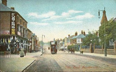
Soho Road, Handsworth (1908)
Handsworth was an area of scattered farmsteads until the 19th century. There were small concentrations of cottages, barely big enough to be called hamlets, at Birchfield, Hamstead, Old Oscott, Perry, Queslett, and Newton End. Towards the end of the 18th century some large villas were built on Handsworth Heath and further building was stimulated with the enclosure of the heath in 1793. By 1840 the southern part of Handsworth parish roughly north of Soho Road and Lozells Road had developed into an upper middle-class a suburb much on a par with Edgbaston, though without the leasehold arrangements that were to preserve the latter's social standing.
Building development northwards was encouraged with the opening in 1837 of Perry Barr station on the Grand Junction Railway (Birmingham-Liverpool) and again after 1854 with the opening of Handsworth & Smethwick station on the Birmingham, Wolverhampton & Dudley Railway. By the end of the century the suburban area had reached northwards into Handsworth Wood, houses there being large and few to the acre.
South of the Holyhead/ Soho Road a much greater density of working-class housing was beginning to be developed. With an increasing population Handsworth Urban Sanitary Authority was set up in 1874. The district became an Urban District under the Local Government Act in 1888 which was amalgamated with the City of Birmingham in 1911.
The Wednesbury Turnpike was set up in 1727 along the present Soho Road/ Holyhead Road. Largely a new road via existing village tracks, it left Birmingham from Bull Street and Snow Hill via Constitution Hill, Great Hampton Street and Hockley Hill, before ascending Soho Hill to what is now the Holyhead Road. At the bottom of Constitution Hill and at Villa Road were tollgates and keeper's cottages which operated until the road was disturnpiked in 1870. This was a vital busy route bringing coal from the Black Country to the iron furnaces of Birmingham. However, it traffic must have decreased dramatically with the opening of the Birmingham Canal to Wednesbury in 1769. In 1781 William Hutton noted of the road: "To Wolverhampton, thirteen miles, much improved since the coal-teams left it."
The road takes its present name from the London-Holyhead Mail Road set up after the 1801 Act of Union when further improvements were made to enable Irish MPs easier access to the port of Holyhead. Thomas Telford raised the road level across the valley of Hockley Brook and reduced the height of Soho Hill.
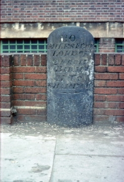
A milestone has survived inscribed: "111 miles from London. 3 miles from Birmingham. 10 miles from Wolverhampton" and is now in the grounds of St James's School nearby. The road was disturnpiked in 1870.
Although it was then only a hamlet, the old village centre of Handsworth lay on the road to Walsall which was turnpiked in 1727 from Soho Hill along Hamstead Road, Handsworth Wood Road, Hamstead Hill, Old Walsall Road and Birmingham Road. Stagecoaches used this route from 1752. William Hutton was less impressed with this route: "The road to Walsall, ten miles, is rather below indifferent."
There was a tollgate and tollhouse at the junction of Hamstead Road and Villa Road. Tollgate Drive now commemorates the fact. This road was bypassed in 1831 by a more direct route, the New Walsall turnpike along Birchfield Road and Walsall Road. The gates here were removed in 1872 and the toll house was subsequently used as a girls' private school. The road was officially disturnpiked in 1879.
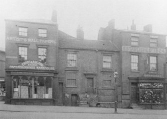
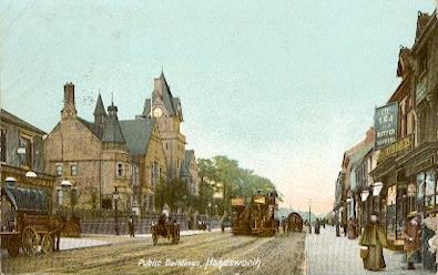
With the building of Handsworth Council House in 1877 the Soho Road became the focus of the area. The population continued to grow, that of 1841 increasing five times by 1891. The chronology of the area's late 19th-century development is reflected in the dates of new Anglican churches and the creation of parishes out of the ancient parish. Most of these buildings now have Listed status.
St James' was built off the Soho Road in 1840 and was greatly enlarged in 1895, St Michael's on Soho Hill was consecrated in 1855, St Chrysostom's on Handsworth Park Road 1888 and St Peter's in Grove Lane 1907. On Oxhill Road St Andrew's, which was originally set up as a mission chapel in 1894, moved into Bidlake's new church building in 1908.
The dissenting population was served by host of non-conformist churches and chapels ranging from grand churches to corrugated iron chapels, including Union Row Wesleyan Chapel built in 1789 which later became a Congregational church and was Handsworth's first Sikh temple in 1972, Westminster Road Congregational Church 1882, Soho Hill Congregational Chapel 1892 and Somerset Road Wesleyan Chapel 1894. Not until 1939 was a Roman Catholic parish created here with the building of St Augustine's on Avenue Road. By 1906 Handsworth was largely built up; much of the remaining farmland was built over during the first quarter of the 20th century, and as the district became increasingly crowded, Handsworth became increasingly a working-class area. Showell's Dictionary of Birmingham described the district in 1888:
"Till within the last thirty or forty years, Handsworth was little more than a pleasant country village, though now a well-populated suburb of Birmingham. After the erection of the once world-known, but now vanished Soho Works, by Matthew Boulton, a gradual change came o'er the scene; cultivated enclosures taking the place of the commons, enclosed in 1793; Boulton's park laid out, good roads made, water-courses cleared, and houses and mansions springing up on all sides, and so continuing on until now, when the parish (which includes Birchfield and Perry Barr) is nearly half covered with streets and houses, churches and chapels, alms-houses and stations, shops, offices, schools, and all the other necessary adjuncts to a populous and thriving community. The Local Board Offices and Free Library, situate in Soho Road, were built in 1878, at a cost of £20,662, and it is a handsome pile of buildings. The library contains about 7,000 volumes. There is talk of erecting public swimming and other baths, and a faint whisper that recreation grounds are not far from view."
Hockley Hill (1898)The district of Hockley straddles Icknield Street; the part east of that road is generally now referred to as the Jewellery Quarter.
The Colmore family gave a hectare of land and £1000 towards the building costs for St Paul's Church. Built from 1777 this is one of Birmingham's few surviving neo-classical designs and is said to be a scaled-down version of St Martin-in-the-Fields in London's Trafalgar Square. The aim was to stimulate demand for this high-class housing development on the rural edge of the crowded town.
At this time most of the pews at St Martin's and St Philip's were let. It was extremely difficult for newcomers, however wealthy, to rent a pew. The alternative was to sit in the few free pews at the back reserved for the poor. A new housing estate with a church whose pews could be purchased was a great incentive to prospective purchasers and gave impetus to sale of plots. St Paul's is now known for its proximity to the Jewellery Quarter as 'The Jewellers' Church'.
For fifty years St Paul's was a highly fashionable church in the midst of an expensive property development. However, as Birmingham's population boomed and industry thrived, the surrounding area became industrialised with poor overcrowded housing. The status of the area continued to decline and the fabric of the church building with it. In 1834 most of Hockley was still a rural area on the western fringe of Birmingham, urban only as far west as Summer Hill Road and as far north as Warstone Lane. However, by 1850 it had been built up from the town centre as far as Hockley Brook, which was the boundary with Aston. And by 1881 the Aston side of the brook was also completely urban with Hockley itself completely built up with working-class housing and industry and encircled by similar urban districts.
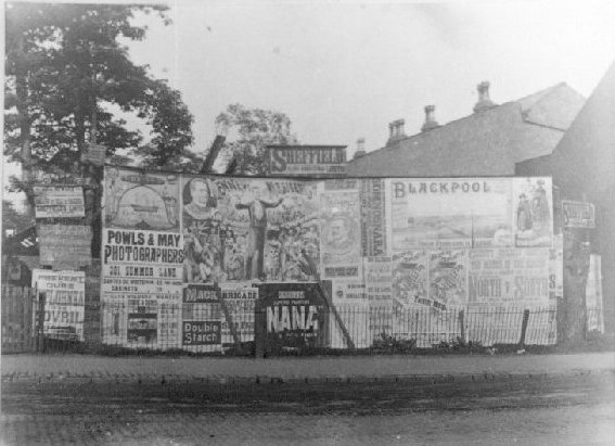
Posters at Soho Hill (1889)
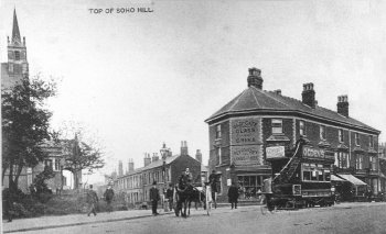
Soho Hill (1910)
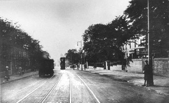
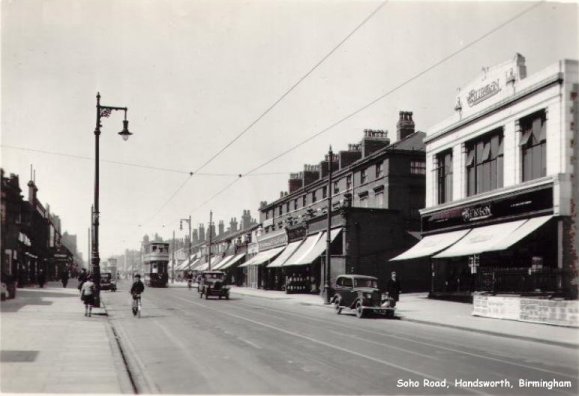
Soho Road, Handsworth
Soho Road, HandsworthOn 20 May 1872 the first horse-tram line in the Midlands was opened by Birmingham & District Tramways. The line ran from the Birmingham boundary at Hockley Brook (Hockley Flyover) along the Soho Road and Holyhead Road through Handsworth to West Bromwich. Twelve crimson and cream open-topped double-decked horse-drawn cars ran on single-track lines. In 1888 the route was converted to an underground cable traction system because of the steep climb up Hockley Hill; the depot was at Whitmore Street, off Hockley Hill. By 1906 all Birmingham lines were electrified with overhead cables. Most of the system was closed down soon after World War 2; the tram station is now a bus depot.
St George's Church (now demolished) from Beilby, Knott & Beilby 1830 An Historical and Descriptive Sketch of Birmingham, a work now in the public domain. Consecrated in 1822, the architect of St George's Hockley was Birmingham-based Thomas Rickman. This was a most important building, the first in Birmingham of a wave of government-funded churches known as Commissioners' churches; the growth of the urban population in the nineteenth century led to steady decline in church attendance and many believed to a decline in morals and increasing lawlessness. Most importantly this was one of the first real attempts anywhere in England at reviving gothic church architecture. To later purists it suffered from having galleries and its columns were thin, but it was built in stone in accurate decorated gothic style. It had innovative cast iron tracery in the windows. When it was built, there were so few houses near Great Hampton Row and Tower Street, that the church was nicknamed 'St' George's in the Fields.' The building was enlarged in 1884. It was demolished in 1960 as part of the wholesale redevelopment of the area.
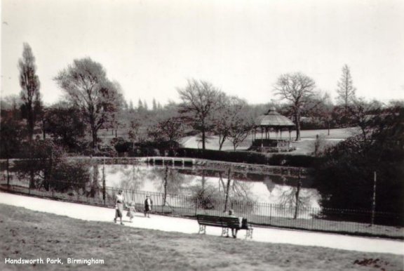
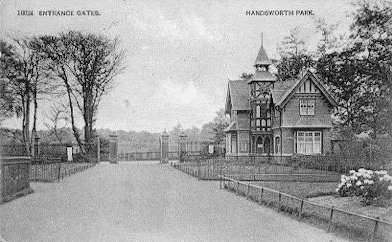
Handsworth Park