Index
- "The Secret Garden" (11th October 1998) Peter Martin, The Sunday Times Magazine at pages 44 to 50
- Large scale satellite image of the Garden of Eden
- References to the Garden of Eden in the Book of Genesis
- David Rohl's "Four Conclusions"
- "Legend: The Genesis of Civilisation" (1998) David M. Rohl at pages 71 to 74
- "The Road to Paradise" (1999) David M. Rohl, Daily Express, Monday, 8th February 1999
- "From Eden to Exile" (2002) David M. Rohl at pages 21 to 29
- References
- "From Eden to Exile" (2007) Eric H. Cline, Chapter 1 at pages 1 to 4, 7, 8, 10, 13, 14 & 15
- "If the Egyptians Drowned in the Red Sea, Where are Pharaoh's Chariots ?" (2005) Benjamin Edidin Scolnic at pages 19 to 27
- "The Historie of the World in Five Bookes" (1614) Sir Walter Raleigh, Chapter 3 Sections 1 to 15
- "Mapping Paradise: A History of Heaven on Earth" (2006) Alessandro Scafi at pages 12 to 15, 369 and 370
- "The Garden of Paradise" (1839) Hans Christian Andersen
Recent Research
- Recent Research
- "Humans 100,000 years older than thought" (2017) Sarah Knapton, The Daily Telegraph
- "The age of the hominin fossils from Jebel Irhoud, Morocco, and the origins of the Middle Stone Age" (2017) Nature
- "New fossil discovery rewrites history of first human beings" (2017) Joel Hruska, Extremetech
- "Homo sapiens 100,000 years older than thought" (2017) Clive Cookson, Financial Times
- "Real location of 'Garden of Eden' cast into doubt by oldest Homo sapiens fossils ever found" (2017) Ian Johnston, The Independent
- "An 85,000-year-old finger fossil may challenge theories about how early humans migrated from Africa" (2018) Meagan Flynn, The Washington Post
- "Red Sea stone tool find hints at hominins' possible route out of Africa" (8th May 2019) Amanuel Beyin, HeritageDaily
- "Oldest human skull outside Africa identified as 210,000 years old" (12th July 2019) HeritageDaily
- "Mysterious 'ghost' populations had multiple trysts with human ancestors" (20th February 2020) Ann Gibbons
- "Garden of Eden FOUND?" (30th April 2019) Daily Express
"The Secret Garden" (11 October 1998) Peter Martin, The Sunday Times Magazine at pages 44 to 50
In the beginning, the Bible describes a fruitful paradise and an ideal man and woman. Now archæologist David Rohl says he has found the real Garden of Eden, in Iran. Peter Martin joined him on a journey through Old Testament country to trace the steps of Adam's descendants back to their original home.
After a 700 mile drive from Ahwaz in the south-west of Iran, we had come out of the northern end of the Zagros Mountains into Azerbaijan province and down onto the Miyandoab Plain, where barren foothills black-dotted with an occasional Bedouin tent had suddenly given way to … there's no other way to say it … an earthly paradise of large, walled gardens right and left, and a profusion of orchards heavy with every kind of fruit. The odd cement factory and petrochemical plant aside, that is. No longer with the road to ourselves, open trucks barrelled along, laden with apples, pears, grapes, melons, maize cobs and bouncing tomatoes. In true-Brit celebration of our arrival, archæologist David Rohl and I exchanged half-daft smiles. With a fine sense of occasion, Siamak Soofi, our interpreter, quoted a line from an ancient Persian song: "Last night I dreamt that the sun and the moon kissed each other."
In its wonderful unlikeliness, the notion suited the moment exactly. For according to very specific geographical references given in the book of Genesis, we had just entered biblical Eden, with the Garden of Eden - Genesis ref: "eastward in Eden" - now all around us and swinging away between two small mountain ranges to our right. Directly ahead, under the far range, lay the sprawling, smog-fuzzed city of Tabriz.
"Paradise lost ?" asked Rohl. But hold on ! The Garden of Eden ? It was important not to get carried away, of course. For one thing, there are walled gardens - Persian gardens, with shade trees and fountains - everywhere in Iran, and nowhere in Genesis does it suggest Adam and Eve took their ease so municipally. Secondly, Tabriz requires to be fed. Hence the intensively worked fruitfulness of the immediate area. It's the city's kitchen garden. But here's a strange thing: in every small town hereabouts, you see at least one big public wall painted with a folk-art depiction of paradise, a mountain of God with water gushing down to dense orchards and lush pastures below. Six thousand years ago, the same icon symbolised the home of Enki, a Sumerian god and the cross-cultural equivalent of Yahweh, God of the Old Testament. At that time, this area was known by two names: Aratta, and the Edin.
But could this really be biblical Eden ? Take chapter two of Genesis, verses 10 to 14. It says there that Eden encompasses the sources of four rivers: the Euphrates and the Hiddekel (Hebrew for the Tigris) - no problem with either of those - plus the Gihon and the Pishon. Scholars since Josephus, the 1st century Jewish historian, have argued as to which two rivers these might be, and you won't find either, as named, on any modern map. According to David Rohl, however, the true identities of the Gihon and Pishon were cracked by one Reginald Walker, a little-known scholar who died 10 years ago. Walker had published his findings in the quaintly titled Still Trowelling , newsletter of the Ancient and Medieval History Book Club, in 1986. "But because the prevailing wisdom even among most biblical scholars is that the Old Testament is little more than myth," said Rohl, "nobody took him seriously."
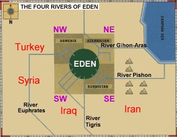
So let's reconsider Walker's findings. Just north-east of where Rohl and I, with our half daft smiles, had entered the supposed Eden, there's a river called the Aras. But before the Islamic invasion of the 8th century AD, as Walker discovered, the Aras was known as the Gaihun, equivalent of the Hebrew Gihon. Amazingly, as Rohl subsequently found, Victorian dictionaries had referred to the river as the Gihon-Aras.
So what of the fourth river rising in the Eden of Genesis, the Pishon ? Walker's only other local candidate was the Uizun. But again, it seems to have given up its secret fairly easily: Pishon, according to Walker, is simply the Hebrew corruption of Uizon, wherein labial "U" becomes labial "P", "z" becomes "sh", while "o" and "u" are well-accepted linguistic variations. [3]
Then Walker made another discovery on one of his maps: a village called Noqdi. Could this be a trace of the land of Nod, the place of Cain's exile after the murder of Abel ? Noqdi's location certainly fitted the Genesis reference: "in the land of Nod, which is east of Eden."
"Reginald Walker never came to Iran," Rohl explained, "and I do have one or two reservations about his phonetic juggling. But, taken altogether, the possibilities were so astonishing, I had to come and see for myself." After two research trips here, during which he discovered additional Eden locators that fitted Genesis, Rohl is convinced.
The likeliest location of the Garden of Eden is by no means the only jaw-dropper in Rohl's new book, Legend: the Genesis of Civilisation, published on 12th October 1998 (Century, £20). But then that's true to form. Just three years ago, in his first book A Test of Time, then in the TV series Pharaohs and Kings, Rohl stood Egyptology on its ear by claiming that the accepted chronology of ancient Egypt was wrong. Not only did he present good evidence that the pharaonic chronology should be shortened by 300 years, when you apply the shorter chronology it makes for an unprecedented series of fits between Egyptian history and Bible narratives.
In the main, academics weren't kind to Rohl's thesis. Leading Bible scholar Professor Thomas L Thompson insisted that any attempt to write history based on "a direct integration of biblical and extra-biblical sources is not only dubious but wholly ludicrous." Then again, in the wake of Rohl's work, Professor Israel Finkelstein, head of archæology at Tel Aviv University, has already lowered the dates of Israelite archæology by a century.
A Test of Time began in the middle of Genesis and gave a new context to Adam's line from Jacob and Joseph onwards. In Legend, the bold Rohl begins with Adam and Eve and affords their immediate line a historical and archæological place. Not all his evidence is original. Indeed, he draws it from a stunning variety of sources and disciplines. But Rohl's real achievement is the way in which he's pieced the evidence together into a coherent, properly magnificent story, the first of all stories, for the first time. He "finds" Noah in all manner of sources, puts a date on the Flood and identifies where the Ark landed; no, it wasn't Mount Ararat - but more of that later. Thereafter, he traces the migration of Noah's spreading line down through the Zagros Mountains into the plain of Sumer. The Sumerians, whose high period was the 4th and 5th millennia BC, were astonishing: inventors of writing, the wheel, metalwork, and seagoing navigation. Then Rohl demonstrates how these people first made sea-trade contact with north Africa, and later swept into Egypt to become the first pharaohs. Erich von Daniken's dingbat theory of a visit from outer space notwithstanding, Legend's exposition, accompanied by splendid photographs and illustrations, would certainly explain how pharaonic Egypt advanced in culture so quickly.
Ahwaz, start point of our journey to Eden, is a ramshackle Klondike of an oil town south of the Zagros Mountains. On the night before setting off, Rohl was explaining the logic of the route. Bizarrely, or perhaps not, the hotel's only Muzak tape was a medley of Christmas carols: "Silent Night", "The Holly and the Ivy", "While Shepherds Watched …"
Of course, we could have "done Eden", plus garden, by flying to Tabriz and jumping into a taxi, as tourists surely will from now on. Instead, we elected to start our journey hard by the plain of Sumer, south of the Zagros. This, so says the Bible, is the place where the descendants of Adam settled in the period immediately following the great Flood. The so-called "pottery trail" is good evidence of that southerly cultural migration. The oldest pottery, 7th millennium BC, comes from north of the Zagros. The next generation of pottery, from the 6th millennium, turns up halfway down through the Zagros. Roughly 2,000 years later, the first "modern" pottery appeared at Uruk, the second city on earth. By then, it was being mass-produced on fast pottery wheels and was of poorer quality than the 7th-millennium coil-made originals. Plus ça change.
Starting south of the Zagros, our self-given task was to make the journey of Adam's line in reverse, to travel backwards in time from Sumer through the Zagros Mountains to the first of all places: Eden. Along the way we would encounter some of the godlike characters and ancient beliefs that inform the Old Testament, including the creation myth of Adam and Eve.
With a 7 am start from Ahwaz, we drove through flat, boring oilfield country in the early light, oil flares against the skyline like tall black candles with tremendous flames, as for Old Nick's birthday. As it happened, we were following a route to Eden that was also taken long ago by a royal emissary. "The world's first postman carrying the world's first royal correspondence" is how Rohl had described him. Told on 3,500-year-old clay tablets indented with cuneiform script, the postman's ancient story forms part of the epic of Enmerkar, who was a priest-king of Uruk. Our postman was the poor instrument of a long-distance argument between Enmerkar in Uruk and the (unnamed) lord of Aratta, Aratta being the Sumerian name for Eden. Enmerkar wanted to build a fabulous temple in Uruk for the great Inanna, goddess of love and fertility, and he repeatedly demanded that the lord of Aratta send him large quantities of precious metals and gems for the job.
"The problem wasn't stinginess on the lord of Aratta's part" Rohl explained, "He was terrified of losing Inanna forever to the cities of the plain. The god Enki had already been removed from the mountains to Eridu, the first city on earth. Now he's going to lose Inanna to Uruk." The royal row went on for years, with the emissary trekking back and forth through the Zagros Mountains, three months each way. It would take us three days.
But how does this Sumerian story tie in with that of Adam's line, post-Flood ? The first genealogical "fix" is that Noah's son Shem appears to have been the eponymous dynastic founder of Sumer - as the linguistic journey went: Shem, Shumer, Sumer. By extensive analysis of ancient legends, Rohl has also demonstrated that Enki is the equivalent of Yahweh, God of the Old Testament. On the same reckoning, Inanna is a niece, if a culturally removed one, of the biblical Eve. Yet another "fix" is the double identity of Enmerkar - who, again, turns out to be a well-known Old Testament figure. But let Rohl do the unmasking:
"The 'kar' part of Enmerkar is an add-on epithet meaning 'hunter', and he is also celebrated as the 'builder-king of Uruk'. But Genesis, too, tells of a 'mighty hunter in the eyes of the Lord' - Nimrod, Noah's great-grandson - and credits him as the builder-king of Erech. Same man, same city ?"
For Rohl, the clincher is in the rest of Enmerkar's name.
"Drop the 'mighty hunter' epithet, and you're left with Enmer. Now knock out the vowels - because early Hebrew didn't record vowels - and you've got Nmr. Now knock out Nimrod's vowels, and who have we here ?" Rohl smiled. "We can argue about that stray 'd', if you like."
Our first stop was to see a man-made mountain of God, the ziggurat at Choga Zambil in what was ancient Elam, just north of Sumer. A youngster as ziggurats go, it was built by the Elamite king Untash Gal in the 2nd millennium BC. A grey desert fox trotted across an upper terrace and disappeared. Over black tea and biscuits sweet enough to make your dental fillings sing falsetto, produced by our Jeevesian driver, Hosien Mokhtari, we discussed sacred mountains and why it was that Old Testament figures would ascend one to talk to God. "You can understand their awe of mountains", said Rohl. "Imagine it - life-giving water in the form of a spring actually coming out of the top of a mountain. Now why would it do that unless God willed it ? A high mountain was where God lived. So once these people had migrated from Eden down through the Zagros here to the plain, they had to build their own mountains by way of ensuring continuous contact with God."
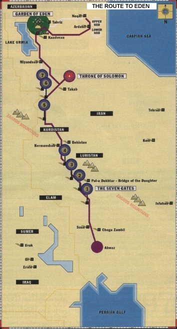
The Choga Zambil ziggurat is a beauty. With a base about the size of three football pitches, the whole thing is girded with information: entire courses of brick going all the way round it, each brick indented with still-crisp cuneiform script. Soofi, pointing out the perfect brick arches, gave a chauvinistic snort: "Roman arches !" Centrally, there's a recessed stone staircase, and at the top there was once a "dark chamber" to which the priest-king would ascend to commune with a god and, according to iconography of the same period, to couple with a prostitute elect. But what had this ziggurat to do with Adam's line ? The name game again: "Chief god of the Elamites was Enshushinak," Rohl explained. "'En' is Sumerian for 'lord'. 'Sush' is the city of Susa, our next stop. 'Inak' we don't know, but it might just be Enoch, Adam's direct descendant - Enoch, lord of Susa ?"
Back on the route of the ancient postman, the sun was getting hot - as in 47o hot - enough to make the eyeballs begin to dry up on a very short walk. "The English know how to make these long trips, especially old English ladies," said Soofi fondly. "But the Spanish, the Italians ! Cut half an hour off their shopping, and they don't speak to you any more."
Next stop: the ancient city of Susa, 3rd millennium BC, and the tomb of Daniel, he of the lions' den. Susa, now a mound like a small South Down, was excavated by the French Egyptologist Jacques de Morgan, in the 1890s. Justly terrified of local brigands, he built Chateau de Morgan, the castle here - "The most impressive dig house in the world," said Rohl, enviously. Beside Susa's mound is what Muslim's believe to be the tomb of Daniel. "Following the Islamic invasion of 8thcentury Persia," Rohl explained, "many exotic sites were named after Old Testament heroes, who also appear in the Koran." Daniel's tomb or not, it's a place of affecting dignity. A mosque, the ceiling inside is a perfect dome - a single point breaking into eight mirrored facets to form the round, then breaking outwards again in prayer-decorated tiles to form the square base building: Persian geometry. "In finer mosques," Soofi told us, "the dome point breaks into 16 facets, sometimes 32. The point is the infinity of God." Beneath the dome, the tomb is now encased in glass and pillared silver. In the immense quiet, local people kissed the tomb and prayed.
Now, following our emissary's route into the foothills of the Zagros, we entered Old Testament country - mud-brick villages, stony hills ploughed to the near-vertical, little lone stacks of flat rocks denoting ownership of crop fields. Here and there, under a rag sunshade, you'd see a lookout keeping a beady eye, especially for sheep going where they shouldn't. Farmer and shepherd: the ancient enmity - Cain and Abel. In the Zagros the only winter fuel is donkey, sheep and goat droppings, which are whacked into briquettes and piled with conspicuous neatness, like village treasure. The country is also dramatically lumpy with another kind of treasure. You see unexcavated occupation mounds everywhere, the sides occasionally crumbled to reveal strata of past millennia. Some villages are built on mounds, their history stacked beneath.
We often encountered the postman's ancient way, the wide, stony track plain to see. Rohl said, "You have to picture him carrying Inanna's sacred standard, and her awe-inspiring effect: 'For her, they humbly saluted with greetings like mice.' En route to the Edin, he had to pass through seven 'gates', as in 'seven steps to heaven'. And the order of the gates, one to seven, starting at Susa, indicates that Aratta (Eden) had the spiritual status of heaven." Traditionally, "gates" are associated with mountain passes, but here they're something special - spectacular river-cut mountain gorges that have their own geological name, tangs. We got out to look at one, standing on the cliff edge, our eyeballs drying, the serpentine Kerkeh River 200 feet below. "What tangs tell us", said Rohl, "is that the rivers were here before the mountains rose up."
When our postman came through, he crossed his third gate, a wide tang, by walking over Pol-e Dokhtar, the Bridge of the Daughter. Whose daughter, nobody knows. One reconstructed arch and a few stone stanchions remain. But high above the spring waterline, his path runs along the cliff terrace past some Neolithic caves, turns left onto the bridge … down a stone ramp on the far side, and off around another mountain. Once, after being dictated a long message by Enmerkar, the emissary was asked to repeat it back but couldn't remember it all: "My Lord, I am heavy of mouth." At which point Enmerkar is credited with writing the world's first letter, on a clay tablet.
Who was Adam ? Aware that he has no hard evidence, Rohl sees him this way: "Adam is a metaphor for the oldest ancestor in memory, the first historical man, the head of a genealogy, a spiritual and political leader in one. He is, too, I think, the representative of the first settled people, former hunter-gatherers, who, through the Neolithic revolution, learnt to domesticate animals and to plant crops. Religion is a function of settlement, of social organisation, of hierarchy, and of needing a political leader/shaman-priest who is in touch with the gods of nature. Adam, with Eve, probably represents an important marriage between two such settled tribes. They're the founding family of civilisation."
"But you can 'find' these foundling characters in different ancient legends. Eve in Genesis is described as 'the mother of all the living', the same epithet used for Ninhursag, the Sumerian 'Mistress of the Mountain'. It looks, too, from the legends, that Inanna is a daughter of the great mother goddess Ninhursag. But you not only find the same characters in different legends. In the Sumerian creation myth, Enki is cursed by Ninhursag for eating forbidden plants growing in paradise. Enki begins to fade away - his ribs pain him - but Ninhursag relents and creates a goddess called Ninti to cure him. Ninti means 'Lady of the Rib' but it also means 'Lady of Life'. It's a Sumerian pun. But the Genesis author simply took the first meaning. And so the story of Eve's creation from Adam's rib was born."
By 8 am next morning, after a night stop in Kermanshah, we'd come to Behistun, source of the Kerkeh River, which we'd been following with our postman since Susa. There's a mountain here, with a lively spring coming out of its base, and a pool with trees curtseying into it, lilies and bulrushes. The ancients believed not only that the earth was flat but that it floated on a freshwater, underworld ocean. Any place where water came out of the rock was known as an abzu - the sacred entrance to and exit from the abyss. This was once a place of Enki, lord of the underworld ocean. "Of course, there's the motif of miraculous spring water all through the Old Testament too", said Rohl. "When Moses and the Israelites are in the desert dying of thirst, the miracle isn't a rainstorm or an oasis appearing. Moses strikes a rock and out comes water."
Today, the most magnificent feature at Behistun is the rock-face bas-relief of the Persian king Darius I meting out royal justice to a whole line of uppity pretenders to his throne. They certainly knew how to do monuments in 521 BC. The entire history of Darius, whose empire stretched from Turkey to Egypt, is written on the rock face in three different cuneiform scripts. But his story was lost to modern understanding until the 1830s, when an intrepid Englishman, Henry Rawlinson, spent the best part of three years dangling from a rope at the rock face deciphering the scripts. Luckily, I'd seen a photograph of the relief in Iranair's in-flight magazine; but it's invisible now, covered with scaffolding and a crude planked roof, under a preservation order.
Long before Darius, there was some Palæolithic occupation here, and the Parthian Greeks left behind an oddly camp statue of Hercules. But now there's a roaring trunk road too, and the pool is circled by hideous concrete. Offended, Rohl was railing about official vandalism when the otherwise affable Soofi lost his temper, arguing that it was the West's fault for inventing concrete, the motorcar and tourism in the first place. After a long sulk, he brightened. "Sure, the Iran government wants tourism but has no idea how to attract it." Then he laughed: "Our officials, they think they smell kebabs, but it's just a donkey being branded."
Three hours on, we were way up into Kurdistan, at the summit of the highest mountain in what Rohl believes is the biblical land of Havilah, "rich in gold and silver". There are a couple of worked-out gold mines in the area and, a few miles on, the Gold and Silver Rivers. We'd stopped at a caravanserai, a travellers haven-cum-fortress, now in ruins. How crafty of Satan to have taken Jesus to a mountain top to tempt him. You feel omnipotent here, all the world beneath you.
By late afternoon we'd come to the Throne of Solomon - another natural mountain of god and home of Enki, but with a lake in the top and a feisty brook spilling out, source of the Gold River. Five metres down, the lake is freezing, appropriate for an entrance to the abyss. Now it's a place of informal pilgrimage and family recreation, kids splashing about in inner tubes. There's also the ruin of a Zoroastrian "fire temple", possibly 1st millennium BC, fire altar still intact. "Remember the magi ?" said Rohl. "According to some Bible scholars, they were most likely Zoroastrian priests. By way of explaining Jesus' famous 'missing years', one theory has him coming to this region for Zoroastrian tutelage."
As we stood at the lakeside, sun touching the horizon, the air was cut by a singing voice, clear and astonishing. The song, The Head of the Caravan, reckoned to have been written in the 14th century, is played over a Tannoy here every sunset. The voice belongs to Iran's celebrated Mohammad Resa Shajarian. "When he was 14", said Soofi, "he sang like a divine eunuch. He's 60 now, and the lady who looks after him is, well, 17." But the music: not four beats to a bar, as in the Spice Girls or Mozart, but 16 beats, sometimes 32, voice and instruments flying between major and minor with no effort or inhibition, a complexity of music of ancient memory, in which you can hear flamenco, Indian, Chinese, Greek, Gaelic. The lake went bronze, then suddenly black. On the drive to Takab, our night stop, Soofi sang for us until he was hoarse. Tomorrow, Eden.
Next morning, we wound down out of the mountains, through the ancient seventh gate, and onto the Miyandoab Plain, where our emissary, "… like a huge serpent prowling about in the plain, was unopposed". His destination was the one-time city of Aratta, which has never been found. And so we entered the supposed heart of Eden and then, passing between Lake Urmia on our left and Mount Sahand on our right, the garden, orchards aplenty, brash Technicolor-painted mountains of god on this wall then that, Rohl and I smiling and gawping, Soofi relating how the sun kissed the moon, and Tabriz up ahead.
What came next was a shock for Rohl especially. The great city walls of Aratta are described in ancient records as being painted with red ochre. This was Rohl's third visit to Tabriz, but he had never entered it in this quality of high-summer light before. "Look at that," he said. The mountain directly behind the city, like no other we'd come across in the Zagros range, is of the reddest ochre clay. It glowed red. "And Adam ?" Having read the book of Rohl - my other, now battered travelling companion - I needed no prompting: Adam made of clay, Adam meaning "red-earth" man in Hebrew. Every myth must have its raw material.
In Iranian cities, since there are no pubs, clubs or trendy restaurants everyone's idea of a glitzy night out is to go to a hotel lobby. In Tabriz, there's only one half-decent hotel, and it was a madness of people: great assemblies of black-clad women, men shouting and smoking like Turks, kids having pushchair races, playing football. Just 10 generations after Adam, humanity had become similarly unruly and noisy. Which is precisely the reason given in Genesis for Yahweh deciding to wipe out his creation. As Genesis also tells it, none of us would be here at all were it not for one wise and devout man, the chosen survivor, Noah, hero of the Flood.
Thus it was, in the teeming hotel lobby, that Rohl told of Noah: "A multicultural sort of character, Noah has three other ancient identities - the Sumerian 'Ziusudra', Old Babylonian 'Atrahasis', and the Akkadian 'Utnapishtim'. As in the story of Noah, Utnapishtim also sends out a dove and a raven to find dry land."
And the date of the Flood ? In his book, after a truly heroic deployment of evidence - including sliding chronologies and a review of water-laid silt strata, most notably at Ur of the Chaldees - Rohl plots it at about 3,100 BC. But he'd reviewed a good number of ancient flood epics - there are over 150 world-wide - before coming across the flood record of the Meso-American Mayan culture. "The Mayan calendar - they were exceptional record-keepers - fixes the date for their great deluge at 3,113 BC. Strange, that."
| Biblical Peoples | |
|---|---|
| The different cultures and dynasties that occupied Old Testament country, according to David Rohl's new chronology | |
| Sumerian | 3100 - 2100 BC |
| Elamite | 3000 - 647 BC |
| Akkadian | 2100 - 1920 BC |
| Old Babylonian | 1667 - 1362 BC |
| Assyrian | 1000 - 612 BC |
| Neo-Babylonian | 625 - 539 BC |
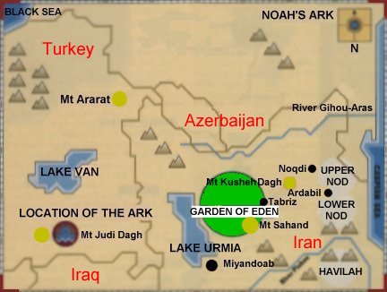
There is a problem with the popular idea that Noah's ark came to rest on Mount Ararat. "The one which recent Christian explorers have been heading off to," said Rohl, "is Mount Aregats, which was first identified as the Mountain of the Descent around the time of Marco Polo, if only for its impressive size. Marco Polo was a notorious fibber, anyway. But Aregats is way across in eastern Turkey, north of Lake Van." So where might the true site be ? "In Genesis it says the ark came to rest on the mountains of Ararat, and all the Jewish and early Christian commentaries place it in the Zagros range in the Land of Kardu, the ancient name of Kurdistan. That's south of Lake Van and south-west of Lake Urmia. The Babylonian priest-historian Berossus, 3rd century BC, even tells of people removing pieces of bitumen from a ship and taking them home as talismans. Then there's the Assyrian king Sennacherib. After campaigning in Kurdistan around 700 BC, he worshipped a plank he'd recovered from the ark."
But which mountain is it, David ? "Well, a lot of people seem to have known - Berossus, and the Koran mentions it, so does the 10th century Muslim writer Ibn Haukal. The pilgrim saint Jacob of Nisibis apparently knew too … It's a mountain called Judi Dagh in the Zagros range about 100 kilometres due north of the town of Mosul. When Sennacherib collected his sacred plank, he celebrated his visit by carving several reliefs of himself at the foot of Judi Dagh. We also know that the 5th century Nestorian Christians built several monasteries there, including one on the summit known as the Cloister of the Ark." Which, taken all together, would seem to settle the matter once and for all.
Next day, we set off to tour the supposed garden, heading "east of Eden", as directed by Genesis. Ten miles out of Tabriz, you're in Old Testament country once more, but not the stony-ground sort. There's a spacious, rural luxuriance, good sheep pasture, dark-soiled fields, the mud-brick villages presiding on their history-packed mounds, with orchards and vineyards drawn close about them, and stands of poplar behind. At the roadside, we bought grapes approaching the size of ping-pong balls.
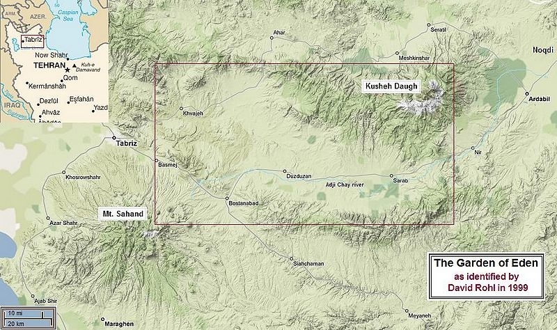
In physical geography, this is a natural garden - a fertile plain some 60 miles wide and 200 long, enclosed between two mountain ranges, which come nearly together at the eastern end. In Genesis, it says the garden is watered by its own unnamed river. But as Rohl confirmed on his first visit, this plain too has its own river winding through it, the Adji Chay. "And just a century ago," he said, "it had been known as the Meidan, which is Persian for 'walled court' or 'enclosed garden'".
Another key reference in Genesis describes the river Gihon as winding "all through the land of Cush". As with the four rivers of Eden, the whereabouts of Cush has been debated for centuries, as Rohl explained. "Josephus associated Cush with the ancient African kingdom of Kush, south of Egypt, making the Gihon the Nile, which prompted others to hazard that the Pishon was the Indus or the Ganges. Spanning three continents, this would have made the original Eden absurdly big."
Rohl's candidate as the locator for the land of Cush is Kusheh Dagh, the Mountain of Kush. Sited about 100 miles east along the garden valley, it forms part of the northern wall. As per Genesis, the Gihon River winds clear through the vicinity. The foothills are lumped all around with unexcavated mounds.
Between them, Walker and Rohl appear to have scored another direct hit with the land of Nod, place of Cain's exile "east of Eden". First, in order to get to the village of Noqdi, you do indeed have to leave the garden valley via its eastern exit. Noqdi itself - standard mud-brick, poplars, orchards - sits at the back of a valley next to an occupation mound so big, you want to fall on it with trowels. Two old men we spoke to knew no history of the village beyond their great-great-grandfathers' time. They had heard tell of another town somewhere in the area, Old Noqdi, but they'd not been there.
The teasing bit is that the "i" of Noqdi means "of". A village "of" Noqd therefore implies a larger region for Noqd. At this frustrating point on his last trip, Rohl went to the nearby town of Ardabil, located some officials and, via them, some local maps. What he found convinced him. "The whole area beyond the eastern exit comprises two districts: Upper Noqd and Lower Noqd. Not to labour the point, but if Cain had gone any further east, he'd have ended up in the Caspian Sea."
We headed back into Eden through Cain's exit. About the possibility of regaining paradise, Soofi said, "Oh, heaven's not there any more. The only way to regain it is inside ourselves." But he had a smile coming on. "Once we had wisdom, then we settled for knowledge, now it's mostly information. As the Koran says, 'like donkeys loaded with books'".
On our last day, we drove a little way south of Tabriz to inspect David Rohl's nomination for the original settlement of the Garden of Eden and Adam's own Mountain of God. Mount Sahand has a small lake in the top, the water rising up through a one-time volcanic chimney. A stream trickles from the summit, then flows through the Garden into Lake Urmia.
As you approach Mount Sahand, there's a narrowish, fertile valley dominated by the small mud-brick town of Osku, which sits on its own bulky occupation mound. "What do you think ?" said Rohl. Yes: if you were a tribe of hunter-gatherers who'd come by a few husbandry and farming skills, and you had scouted the whole area for he ideal spot to settle, this would be it. It's as if the plain has lapped up into the valley and left its lush best just here: dark earth and an extraordinary density of olive groves, fruit orchards, walnut and almond trees. It's so comfortable besides: well-watered by the river, in the lee of the mountain, with benign puffy-breasted hills leading down to the valley floor. This would be a place to make home.
A few miles on, near the summit of the mountain, there's a sight to sober any western mind … cave dwellers … a troglodyte village called Kandovan, which means "honeycomb-like", after the rock-hole dwellings. The inhabitants think of this as their mountain. Of Turkish origin, they call it Jam Daghi, Mountain of the Chalice, and hold its cascading river to be sacred, using it for everything they need with due respect. Sole concessions to the present millennium are a village phone line, front doors on the caves, windows wedged in, and a corner shop selling cigarettes and sweets.
Like the Throne of Solomon, the Mountain of the Chalice is a place of pilgrimage and recreation - and of healing. The water is said to be especially good for the kidneys. Coachloads of schoolchildren, girls black-clad and faces covered, come for the educational experience. There are tourists too, but the villagers appear to give no quarter. Mercedes vs. donkey driver in a stony narrow street ? Mercedes backs up. Literally holed up above the snow line for three months of every year, Kandovans stow their animals in cave cellars next to or under their living rooms. But they work their fertile mountain hard and it gives back a saleable surplus: corn, fruit, nuts, seeds, herbs and flower medicines.
The mountain has a sort of double summit: twin peaks. Certainly one, the Mountain of the Chalice, was once a home designate of Enki. And the other ? "The 'Bright Mountain of Inanna', I shouldn't wonder," said Rohl. Of course, he's bound to be wrong on a few points, but that hardly matters up against the accumulated evidence of his thesis overall: the decoding and plotting of the four named rivers of Eden; the discovery of the unnamed river that was said to water the garden; the identification of the lands of Havilah and Cush; and the fair certainty that the place of Cain's exile, the land of Nod, is there still. Rohl didn't ask me the big question, but the answer is yea and verily: I do believe I have been to the Garden of Eden.
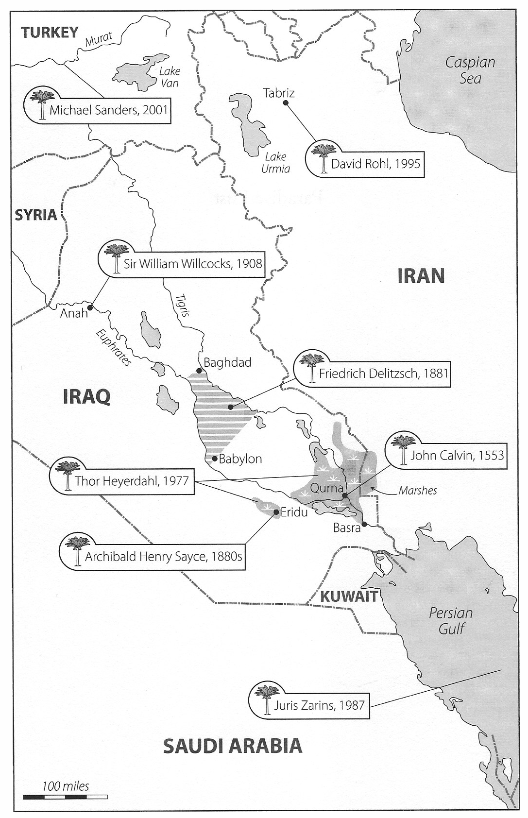
To view a large scale satellite image of the Garden of Eden and Joseph Moxon's 1715 map "Paradise, or the garden of Eden", click here
References to the Garden of Eden in the Book of Genesis
The Book of Genesis (Greek: Γένεσις, "birth", "origin") or Bereishit (Hebrew: בְּרֵאשִׁית, "in the beginning") is the first book of the Hebrew Bible, and the first of five books of the Torah, called the Pentateuch in the Christian Old Testament. Named for the Greek word for "origins", Genesis is the "Book of Beginnings" - the beginning of the Bible, and accounts of the beginning of the universe, earth, and its inhabitants starting with humans.
Genesis 2
8: And the Lord God planted a garden eastward in Eden; and there he put the man whom he had formed.
9: And out of the ground made the Lord God to grow every tree that is pleasant to the sight, and good for food; the tree of life also in the midst of the garden, and the tree of knowledge of good and evil.
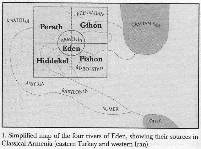
10: And a river went out of Eden to water the garden; and from thence it was parted, and became into four heads.
11: The name of the first is Pison: that is it which compasseth the whole land of Havilah, where there is gold;
12: And the gold of that land is good: there is bdellium and the onyx stone.
13: And the name of the second river is Gihon: the same is it that compasseth the whole land of Ethiopia.
14: And the name of the third river is Hiddekel: that is it which goeth toward the east of Assyria. And the fourth river is Euphrates.
15: And the Lord God took the man, and put him into the garden of Eden to dress it and to keep it.
Genesis 3
23: Therefore the Lord God sent him forth from the garden of Eden, to till the ground from whence he was taken.
24: So he drove out the man; and he placed at the east of the garden of Eden Cherubims, and a flaming sword which turned every way, to keep the way of the tree of life.
Genesis 4
16: And Cain went out from the presence of the Lord, and dwelt in the land of Nod, on the east of Eden.
David Rohl's "Four Conclusions"
In Legend: The Genesis of Civilisation the author draws the four following conclusions:
| Conclusion One: | the four rivers of Genesis 10:14 are the Kezel Uizhun (Hebrew, Pishon), the Gaihun/Aras (Hebrew, Gihon), the Tigris (Hebrew, Hiddekel) and the Euphrates (Hebrew, Perath). |
| Conclusion Two: | the biblical land of Cush was located in Azerbaijan whilst the land of Havilah was located in the Iranian mountain region now known as Anguran. |
| Conclusion Three: | the biblical Garden of Eden is to be identified with the Adji Chay valley (formerly known as the Meidan valley) in north-west Iran at the heart of which is the regional capital of Tabriz. |
| Conclusion Four: | the land of Nod was located in the plain west of the Elburz mountains around the city of Ardabil. |
[3] Editor's note: Reginald Arthur Walker (1917 - 1989) in his paper "The Real Land of Eden" published by the Ancient and Medieval History Book Club (No 11, 1986). Walker's conclusion regarding the four great rivers of Genesis, taking them in reverse order, is as follows:
- the Perath (Sumerian Buranum) is the river known to the Greeks as the Euphrates
- the Hiddekel (Sumerian Idiglat) is the Hebrew name of the River Tigris
- the identity of the Gihon is a little more difficult to establish but, as Walker discovered, it is to be identified with the River Araxes
- the Pishon is, according to Walker's arguments, the River Uizhun which rises from several springs located near Mount Sahand (an extinct volcano east of Lake Urmis) and the Zagros mountain massif around the Kurdish capital of Sanandaj. It outflows into the Caspian Sea not far from the modern port of Rast. The Uizhun is also known as the Kezel Uzun ('long gold'). There is no obvious connection between the names Pishon and Uizhun but the geographical overview confirms the identification.
David Rohl suggests that the Land of Eden was a vast area referred to in ancient Sumerian texts as the Edin (literally "Plain" or "Steppe"), north of Mesopotamia beyond the Zagros mountains. The Garden of Eden was then located in a long valley 'in the east of Eden', to the north of Sahand volcano, near Tabriz. He cites several geographical similarities and toponyms which he believes match the Biblical description, including the four river headwaters of the Tigris (Hiddekel), Euphrates (Perath), Gaihun-Aras (Gihon) and Uizun (Pishon); the mountain range of Kusheh Dagh (the land of Cush); and Upper and Lower Noqdi (the Land of Nod).
"Legend: The Genesis of Civilisation" (1998) David M. Rohl at pages 71 to 74
Chapter 1
Paradise Found
Let us bring together what we have discovered so far about the mythical land of Eden and its paradisiacal garden.
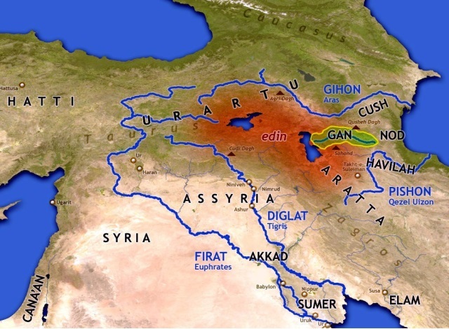
First of all we can say with some confidence that Eden does exist - it is not a purely mythical place deprived of a real geographical setting. Eden is located in ancient Armenia with its heartland in the Lake Van and Lake Urmia basins. This is also the region the Bible calls Ararat - the Assyrian Urartu. The four rivers which flow from Eden are the Euphrates, the Tigris, the Gaihun-Aras (Gihon) and the Uizhon (Pishon).
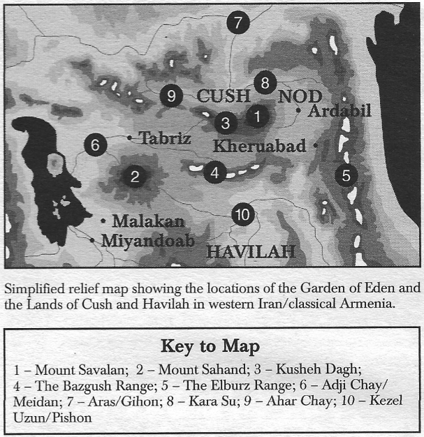
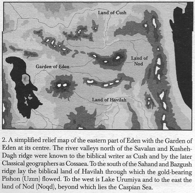
The Garden of Eden has also been located. It lies at the western end of the Adji Chay valley, near the city of Tabriz. The Garden is 'in the east of Eden' and is protected on its north, east and south sides by the mountain peaks of the Savalan and Sahand ranges. To the west are the treacherous marshlands of the Adji Chay delta stretching out into Lake Urmia. The Adji Chay has an older name - the Meidan - which means 'walled-garden' - this is the river, described in Genesis 2:10, which waters the Garden of Eden.
To the east of the Garden the valley gradually ascends to a mountain pass which is the eastern gateway into Eden. Beyond, in the Ardabil basin, lies the land of Nod - the destination of Cain's exile. Several villages in this area still hold a dim memory of the ancient biblical toponym in their modern names. At the outflow of the pass leading from the south and east into Nod, and therefore beyond to Eden, stands the town of Kheruabad - the 'settlement of the Kheru' - a name which may provide a link to the ferocious winged guardians of the eastern gateway into Eden. The Bible calls them the Kerubim - the Cherubs.
To the north of the valley of the Garden lies the 'Mountain of Kush' (Kisheh Dagh) and, beyond, the biblical land of Cush. Through Cush flows the Gihon river, identified with the mighty Araxes river which was called the Gaihun at the time of the Islamic invasions of Persia.
To the south of the Garden, beyond the Sahand and Bazgush mountain ranges, lies the land of Havilah 'rich in gold'. This is the Iranian province of Anguran stretching from the Talesh mountains in the east to the Miyandoab plain in the west. This mountainous region is watered by numerous fast-flowing streams which cascade down from the volcanic peaks and gather together into the meandering Kezel Uzun river - the biblical Pishon which 'winds all through the land of Havilah'. The district of Anguran is renowned for its mineral wealth just as Havilah was renowned for its gold and semi-precious stones. And one other incredibly rare stone is found here which is going to play a part in our story - lapis lazuli (the 'blue stone' of gods and kings).
We seem to be doing pretty well in our search for the origins of the Genesis story - especially considering that any attempts to locate Eden are doomed to failure in the view of most academics. Walker's topographical discoveries have uncovered the physical geography of the Edenic legends, but is there more to unearth from sources outside the Judaeo-Christian tradition ?
So far we have been concentrating predominantly on Chapter Two of Genesis and the geography of modern western Iran. I think we have probably learnt as much as we can from the biblical record. Now it is time to turn to the extra-biblical sources - in particular the epic literature of the Sumerians, the foremost of ancient world civilisations.
What we find is rather interesting. The Sumerians do refer to a mystical land beyond the mountains - but it is not called Eden. The Sumerian paradise is the kingdom of Aratta, rich in gold, silver, lapis lazuli and building stone. We will learn that it is the place where gods originated, the 'Land of the Living' and the far-off world to which the archetypal Sumerian hero journeys to seek his destiny.
"The Road to Paradise" (1999) David M. Rohl, Daily Express, Monday, 8th February 1999
The snow-covered dome of the Mountain of God, shrouded in billowing clouds, towered above the old Mongol village known locally as 'the honeycomb'. Earlier that morning I had set out on a pilgrimage to the Exalted Throne of Yahweh where Adam's god dwelt. Within an hour the noise and chaos of Tabriz had been left far behind, as our four-wheel drive ascended out of the alpine valley of the Adji Chay onto the plateau of the Sahand massif, with imposing volcano at its heart. Now I found myself at the entrance to one of our world's most extraordinary places - the troglodyte village of Kandovan.
Ambling down the cobbled street - only just wide enough to take a donkey and cart - I turned up a steep side alley, all the time stalked by a clutch of free-roaming chickens. The alley soon morphed into a roughly sculpted flight of steps which twisted and turned between huge canine teeth of lava. Each was a home - a dwelling from a bygone age with rickety wooden door and tiny mullioned windows. In this Dysneyesque landscape of cave-dwellers, I almost expected Pinocchio to appear around the next bend.
Kandovan - 'The Honeycombe'
My long journey, starting in the research libraries of London University, had led me to the Mesopotamian flood plain and on up into the mountains of Kurdistan, finally to reach the place the Book of Genesis calls the Garden of Eden.
There is no straightforward way to explain how an Egyptologist, used to working in the dry heat of the north African deserts, should end up traversing the Zagros mountains of western Iran in search of the earthly paradise. I had begun my studies in the Departments of Egyptology and Ancient History at University College, London, with a major interest in the complex chronology of Egyptian civilisation. My PhD work to radically revise that chronology had inevitably drawn me into the world of biblical history - so closely bound up with the land of the pharaohs. Years of research had led me to the conclusion that many of the stories in the Old Testament were based on real historical events: the Isrælite sojourn in Egypt, the Exodus, the conquest of the Promised Land - all were attestable within the archæological record once the correct chronology had been applied.
But why was I now delving into the Book of Genesis - that most mythological and hoary of the biblical texts ? Surely it would have been better to leave well alone ? But that is not my way. The simple fact is that ancient stories and legends have always fascinated me and the chance to uncover the historical reality behind the greatest legend of them all was just too tempting an opportunity to pass by.
The 'Temptation Seal' on display in the British Museum
Back in 1987 I had been sent a short, privately published paper by amateur historian, Reginald Walker (1917-1989), which proposed a location for the Garden of Eden in north-western Iran. The main thrust of Walker's argument was that the four rivers of Eden, described in Chapter Two of Genesis, were to be found in that region. All four had their sources (the Bible refers to them as 'heads') around the two great salt lakes of Van and Urmia.
Ever since the time of the Jewish historian Josephus, a near contemporary of Christ, scholars have tried to use Genesis 2 to locate Eden. But the problem has always been the identification of the rivers themselves. The Bible calls them Perath, Hiddekel, Gihon and Pishon. The first two are no problem: the Perath is simply the Hebrew version of Arabic Firat and Greek Euphrates; similarly the Hiddekel is Hebrew for Sumerian Idiglat from which the Greek Tigris derives. The remaining two rivers, however, have always been a mystery. Clearly, in order to locate Eden precisely, we need to find the sources of all four - and that's where Walker's research comes in.
He showed that the River Aras, flowing into the Caspian Sea from the mountains north of Lake Urmia, was once called the Gaihun. By checking the writings of the Islamic geographers who accompanied the Arabic invasion of Persia in the 8th century, I was able to confirm that this was indeed the case. Moreover, even as late as the last century, Victorian atlases and encyclopædias were still naming the river as the Gaihun-Aras. The Gaihun is therefore the missing biblical Gihon.
The fourth river - the Pishon - was more difficult to find. Walker suggested that this Hebrew (West Semitic) name derived from the old Iranian Uizhun, where the Iranian vowel 'U' had been converted into the Semitic labial consonant 'P'. Thus we have Uizhun to Pizhun to Pishon. Strange as it may seem, such switches do occur between the two language groups. For instance, one archæological site in Iran is known by its Arabic (West Semitic) name of Pisdeli whereas its ancient (Iranian) name was Uishteri. The river Uizhun (the modern Qezel Uzun) - thus identified as the biblical Pishon - flows down from the mountains of Kurdistan and empties into the southern basin of the Caspian Sea.
The four rivers of Eden
Bringing all this together we find that the sources of all four rivers originate in the highland area which Alexander the Great knew as Armenia and we know today as eastern Turkey and western Iran.
An extra-biblical Sumerian epic known as 'Enmerkar and the Lord of Aratta' relates the tale of a journey made by the envoy of Enmerkar, King of Uruk, from his home city in southern Mesopotamia, through the seven high passes of the Zagros range and down into the magical kingdom of Aratta - the 'Eldorado' of the ancient world. Enmerkar was the second ruler of Uruk after the Flood, according to the Sumerian King List. A crucial line in the epic describes the envoy descending from the last of the seven mountain passes (the Sumerians called them 'gates') and crossing a broad plain before arriving at the city of Aratta with its red-painted city wall.
The envoy, journeying to Aratta, covered his feet with the dust of the road and stirred up the pebbles of the mountains. Five gates, six gates, seven gates he traversed. Like a huge serpent prowling about in the plain, he was unopposed. He lifted up his eyes as he approached Aratta. [extracts from 'Enmerkar and the Lord of Aratta']
Here, the Sumerian word for 'plain' is edin which some scholars believe is the source of the word Eden in Genesis.
So, combining Walker's discovery of the four rivers together with the Sumerian location of Eden, it seemed as though the whereabouts of the lost Eden and its fabled garden was near to being resolved. I decided to set out for the ancient city of Susa (burial place of Daniel of the lions' den) in the south-western flood plain of Iran (Iraq was off bounds for obvious reasons) from where I determined to retrace the Sumerian envoy's route to paradise.
The location of Eden (red shading) in Western Iran and Eastern Turkey
Following the ancient track through the seven 'gates', I eventually reached the Miyandoab plain to the south of Lake Urmia. The journey had taken four days by car but would have taken the envoy the best part of four months by donkey. The edin remains today one of the lushest regions of the Middle East: thick soil, fruit orchards and vineyards, lazy meandering rivers. This, I am sure, was the original heart of Eden which, over time, became a much wider area, including both the salt lakes and the Garden of Eden itself. The Bible describes the latter as being 'east in Eden' - in other words to the east of but still within the wider territory of Eden.
My driver and I continued eastwards, between the south-eastern shore of Lake Urmia and the towering volcanic peak of Mount Sahand. An hour's drive along the highway brought us into a long west to east valley, the slopes of which were terraced with 'every kind of tree' smothered in spring blossom.
God planted a garden in Eden, which is in the east, and there he put the man he had fashioned. From the soil, God caused to grow every kind of tree, enticing to look at and good to eat. [Genesis 2:8-9]
All around a high snow-laden ring enclosed the valley, nurturing its warm micro-climate. The nearest mountain to the north glowed bright red in the low evening light - a pile of pure red ochre. At its foot sprawled the regional capital of Tabriz, squatting at the centre of the valley where Adam and Eve (whoever they were) once lived according to biblical tradition. The first thing which came to mind was paradise lost. Nothing of the earthly garden and its settlement could have survived beneath these bustling streets. But then, away from the city, I soon discovered that there was much that remains of Adam's Neolithic culture.
Paradise Lost - the sprawling city of Tabriz
This was the region where Man first began to settle down to sedentary life; where he learnt to domesticate animals and plant his crops; and where he began to bury his dead in graves, the bones painted in red-ochre. Adam's name means the 'red-earth' man. According to Sumerian mythology, Man was crafted by the gods from the clay of the earth, just as a potter throws his red clay pots on the wheel.
The creation of Man in Genesis is much the same. Yahweh God shaped Man (Hebrew Adam) from the dust (Hebrew aphar) of the earth (Hebrew adamah) and blew the breath of life into his nostrils, and Man became a living being. [Genesis 2:7] … return to the earth (Hebrew adamah), as you were taken from it. For dust (Hebrew aphar) you are and to dust (Hebrew aphar) you shall return. [Genesis 3:19].
Here the word 'dust' is a poetical translation. The understanding of Hebrew aphar is the earth from which clay is made, or simply clay itself, and I believe the clay which gave Adam his name was sourced in the red mountain looking down on Tabriz. Throughout many prehistoric cultures (and including the later Mesoamerican civilisations such as the Maya) the daubing of human bones in red paint or powder was a substitute for the life-blood which had been lost with the decaying flesh.
The Hebrew word for 'garden' used in Garden of Eden is gan which has the meaning 'walled' or 'enclosed garden'. The enclosed valley of the Adji Chay is just that - a rich-soiled paradisiacal haven protected by high mountain walls. The Greek version of the Old Testament calls the Garden of Eden 'Paradise' (paradeisos) after the ancient Persian pairidæza meaning 'enclosed parkland'. The great Meidans (royal squares) of Islamic Persia, particularly the beautiful Meidan-é Imam of Isfahan, are symbolic representations of the original Garden of Eden with their high enclosures and formal gardens containing fountains and pools.
When the descendants of the Mongol chieftains who had invaded Persia in the 13th century moved on into India to become the Mogul emperors of the 16th to 19th centuries, they took the Persian ideas relating to the Garden of Eden with them. So it was that Shah Jehan built the Taj Mahal for his beloved queen, Muntaz Mahal, not simply as a mausoleum but as a representation of heaven itself - with the mausoleum functioning as the Throne of God. Jehan was effectively recreating the paradise on earth which had been lost to humanity following the expulsion of Adam and Eve from the Garden of Eden. A study of the Koranic inscriptions around the arches of the Taj, undertaken by Professor Wayne E. Begley of Iowa University, has shown that this was the hidden secret of the building - the sacred knowledge of Eden brought out of Sufic Iran.
The Taj Mahal - an architects reconstruction of Eden
However, now that the landscape of Eden and its garden have finally been identified, I believe we are in a position to read much more into this extraordinary 17th-century monument to one man's vanity.
I shall scale the heavens. Higher than the stars of God I shall set my throne. I shall sit on the Mountain of the Assembly far away to the north. I shall climb high above the clouds; I shall rival the Most High. [Isaiah 14:13-14]
The Taj Mahal's glistening white dome, can be seen as a representation of the snow-capped Mount Sahand - the original exalted throne of God. The formal gardens in front of the Taj mirror the garden of paradise with the central pool (representing Lake Urmia) and the four water channels (representing the four rivers of Eden) flowing out from the centre of the complex. The ornamental arch leading into the enclosed garden of the Taj Mahal represents the mountain pass or 'gate' leading into Eden which was ferociously guarded by the cherubim and the Fiery Flashing Sword. The symbolism is striking.
But, back in the real Garden of Eden, we still have much more to discover. Even further to the east of the Adji Chay valley and Tabriz, beyond a high pass leading out of the Garden of Eden, is the land of Nod into which Cain was exiled after he had murdered his brother Abel. The area is still today called Upper and Lower Noqdi and many villages bear the epithet Noqdi ('belonging to Nod').
In the same region we find the town of Kheruabad. The name means 'settlement of the Kheru-people' and the Kheru were the Kerubim (Cherubs) of Genesis who protected the eastern entrance into Eden. The volcanic peak which guards the eastern gateway back into the Garden of Eden is a good candidate for the 'Fiery Flashing Sword' associated with the Kerubim. When I travelled over the pass beneath Savalan volcano for the first time, the vehicle was pounded by a violent electrical storm. To the ancients, used to the metaphor of jagged peaks as divine swords or spears, it would have been easy to envisage the angry mountain, casting down its bolts of lightening, as the Fiery Flashing Sword of Genesis.
The Garden of Eden in Western Iran
I returned to Eden from Nod by a different route, travelling along the valley of the Ahar Chay - the next river basin north of the Adji Chay. The Ahar Chay is a major tributary of the Gaihun-Aras/Gihon which, according to Genesis 2 'winds all through the land of Cush'. My map confirmed once more that we really were in the primordial landscape of Adam and Eve. Separating the Ahar and Adji valleys, and acting as the northern wall of the Garden of Eden, stretched a high snow-capped ridge named Kusheh Dagh - the 'Mountain of Cush'.
Long after nightfall I was back in my Tabriz Intercontinental Hotel bed, dreaming of an early morning climb up to the Mountain of God.
The troglodyte village of Kandovan seems as old as the mountain to which it clings. We can certainly record its history back to the Mongol invasion of Persia in the 13th century when a group of settlers occupied the village. But none of today's locals have memories beyond the arrival of their Asiatic ancestors. Did the village exist before that time? It seems highly likely, given the complex agricultural terracing which covers the steep-sided valleys around the holy mountain. Assyrian war annals of the 8th century BC mention towns in the vicinity of Mount Uash (the Assyrian name for Sahand volcano) and these population centres would have required considerable agricultural produce which must have been eked out of the volcanic soil clinging to the slopes of Sahand. Beyond the 8th century BC we cannot go with any certainty, but Neolithic occupation around Lake Urmia and Mount Sahand has been confirmed by limited archæological investigations. Of the thousands of ancient occupation mounds surveyed in this region only a tiny percentage have been excavated. We have just begun to scratch the surface in the land where human civilisation began.
Whatever the ancient history of Kandovan, the soul of the place is timeless. Hardly anything has changed over the centuries - until very recently, that is, when electricity was piped up from Tabriz. The only other concession to the modern world is a fag shop and a picnic area for Tabrizi weekend tourists. They come up the mountain armed with plastic containers to collect the water which flows down from the nearby summit of the mountain. This water is regarded as having magical properties: it cures the sick and prolongs life. Many a grandma or grandpa in Tabriz are fed the holy water of Mount Sahand to keep them fit and strong. The reason for this veneration is all to do with the sacred source of the river which runs through the Garden of Eden.
At the summit of one of the two peaks of Sahand the extinct volcanic chimney overflows with ice-cool water as if from a bottomless well. The locals call it Jam Daghi - 'Mountain of the Chalice'. The water which gurgles from the tiny lake joins other streams, flows past Kandovan and on down into the Adji Chay valley, eventually forming a marshy delta on the eastern shore of Lake Urmia.
A river flowed from Eden to water the garden, and from there it divided to make four streams (Hebrew roshim meaning 'heads'). [Genesis 2:10]
In Sumerian theology spring-water lakes on top of mountains were regarded as holy places where humans might communicate with the great god of the underworld ocean of sweet water upon which the earth floated. Such an interface between the worlds of the living and dead was called an abzu, from which we get our word abyss. The god of the abzu was known to the Sumerians as Enki ('Lord of the Earth') - the creator of humankind and the 'friend of Man'. The Akkadians and Babylonians knew him as Ea (pronounced Éya) and it was this Ea who warned the Mesopotamian hero of the flood of the impending destruction of mankind by the storm-god, Elil (Sumerian Enlil). Could Ea, god of the Sahand abyss, have been the deity worshipped by Adam and Noah? You will have to wait for another day for the story of the flood when I will reveal the hidden name borne by the god of the Isrælite ancestors.
Meanwhile, the troglodyte village of Kandovan with its volcanic spires was as close as I could get to Adam's world. I had travelled over one thousand kilometres from the Mesopotamian plain to the Garden of God. I had crossed seven mountain ridges, through the ancient lands of Kuzestan, Luristan and Kurdistan. I had followed in the footsteps of Enmerkar's weary envoy as he crossed over into the mysterious land of Aratta and, beyond, I had found myself in the primeval world of Adam and Eve. I was literally in Seventh Heaven. My journey had come to an end just below the summit of God's holy mountain. The Exalted Throne of God was within reach, a thousand metres above me, but sadly not this time. Dark clouds had enveloped the mountain and falling snow began to shroud the way forward. My meeting with God would have to wait for another time. I headed down the mountain, leaving Pinocchio and his friends to their own devices.
Son of Man, raise a lament … You were in Eden, in the Garden of God … I made you a living creature with outstretched wings, as guardian, you were upon the holy Mountain of God, you walked in the midst of red-hot coals … I have cast you down from the Mountain of God and destroyed you, guardian winged creature, amid the coals. [Ezekiel 28:11-19]
"From Eden to Exile" (2002) David M. Rohl at pages 21 to 29
Chapter One
Adam and the Garden of Eden
Genesis 2:8 to Genesis 4:16
In the beginning - the beginning of memory - there was once a luxuriant land called Eden with a paradisal garden set towards its eastern limits. Eden lay beyond the broad mountain range which separates the Mesopotamian plain from the steppes of central Asia, its heartland located in the area of the two great salt lakes of Van and Urumiya. The lush primeval valleys and plains of eden were hemmed in by tall snowcapped peaks, their slopes covered in a dense canopy of pine (erini) and cedar (survan) forest. Later, the Persians would simply know the place as pairidaeza - Paradise.
Four of the ancient world's great rivers flowed from Eden. The headwaters of the Hiddekel (Tigris) and Perath (Euphrates) were located in the west, whilst those of the Gihon (Gaihun-Aras), flowing through the land of Havilah, rose in its eastern part.
Eden was the place which gave birth to civilisation - the womb of the great earth-goddess and the mother of the Neolithic Revolution. This was the time when Stone Age Man finally gave up the wandering hunter-gatherer way of life, settled in villages and began to raise crops and domestic animals.
Located in the eastern part of the sparsely populated region of Eden was a long east-west valley, protected by high mountains on three sides. The sun rose at one end and set at the other. To the north stretched the Mountains of Cush beyond which lay the land of the same name, through which flowed the River Gihon. At its eastern end, the range culminated in the rocky volcaniv pinnacle of Mount Savalan, guarding the eastern entrance into Eden. To the south the snow-topped Bazgush ridge separated the valley from the Land of Havilah with its fast flowing streams, rich in gold, which joined to form the meandering River Pishon. At the western end of this southern range rose the mountain massif of Sahand - an icy world of glistening volcanic peaks. The valley was bounded on its west side by salty Lake Urumiya beyond a broad area of inhospitable marshland and salt flats.
It was here in this lush valley 'in the east of Eden' [Genesis 2:8] that Adam and his people settled. The epic story of the Children of Yahweh begins here in this first of all gardens - the Bible's Earthly paradise.
The 'garden' (Hebrew gan) into which the Adamites had arrived was sheltered on three sides - a haven from the worst of the highland climate and a refuge from nomadic bands moving through the surrounding mountains along the major communication routes. Westerly winds brought warm rain from the Mediterranean, creating a micro-climate in the long narrow valley. This extra moisture encouraged dense vegetation growth and an amazing variety of fruit-bearing tress 'enticing to look at and good to eat' [Genesis 2:9]. In deep red soil covering the foothills, orchards of apple, apricot, pistachio and almond grew in abundance. Intermingled with the fruit- and nut-bearing trees, wild vines entwined the natural sloping terraces, heavily laden with bunches of sweet green grapes. The vine was the Tree of Life at the heart of Eden.
Scattered across the valley floor Adam's people found bubbling hot springs which watered meadows carpeted in wild flowers. And through the centre of this idyll flowed a river, the numerous sources of which originated atop the summits of the surrounding peaks. The river of the Garden flowed westwards before disgorging into the swapms of Urumiya. Today this river is called the Adji Chay - the 'bitter waters' - because of the high mineral content washed down from the metal-rich mountains. Its more ancient name was Maidan, meaning 'Royal Garden'.
Here was a place that had everything. Adam and his followers established their roots in this virginal landscape - the legendary Garden of Eden.
The Red Earth Man
Adam was both the ruler and high priest of his community. He was in tune with the voices of nature which spoke to him in vision and trance. Adam knew the power of the plants and the animals.
He was also well aware of the harsh realities of life and its inevitable end. The great MOTHER EARTH regularly took back the bodies of the creatures she had created, leaving only bleached bones as witness to their brief existence. Earth to earth, dust to dust - or, more correctly, clay to clay [Genesis 3:19]. Just as the potter produced vessels on his potter's wheel, so the gods (Hebrew elohim, Sumerian igigi) made Man in their likeness from the clay of Mother Earth on a potter's wheel.
The gods (elohim) said, 'Let us make Man in our own image, in the likeness of ourselves, and let them be masters of the fish and the sea, the birds of heaven, the cattle, all the wild animals, and all the creatures that creep along the ground.' [Genesis 1:26]
They (the gods) summoned the goddess, the midwife of the gods, wise Mami ('mummy' = Ninhursag), and asked: 'You are the womb-goddess, creator of Mankind! Create a mortal, that he may bear the yoke!' … Enki ('Lord of the Earth') made his voice heard and spoke to the great gods: '… Then one god should be slaughtered … NINTU ('Lady of Birth') shall mix clay with his flesh and blood. Then God and Man shall be mixed together in clay'. [Atrahasis Epic 1:4]
Yahweh shaped Man from the clay of the ground and blew the breath of life into his nostrils, and Man became a living being. Yahweh planted a garden in the east of Eden and there he put the man he had fashioned. [Genesis 2:7-8]
Yahweh took the man and settled him in the Garden of Eden to cultivate and take care of it. [Genesis 2:15]
In the creation mythology of ancient Mesopotamia Man was made in the likeness of the gods by combining the clay of the earth with the blood of a sacrificed god. So it was that Adam received his own traditional name meaning 'red earth' - the red earth or clay taken from the Red Mountain overlooking the Garden. Excavations in Eden have revealed that red ochre was used to paint the walls of the houses, decorate clay figurines and cover the bones of the dead as 'replacement blood' or as a substitute for the flesh stripped from the bones by carrion [1]. Adam knew the earth because he was of the earth.
Mountain of God
To the south of the settlement a narrow, steep-sided valley rose up in the direction of the most prominent mountain at the western end of the Garden.The great snow-covered dome of the mountain towered above the orchards, its summit often shrouded in clouds. One day Adam decided to follow the stream up the valley. The fast-flowing brook, charged with ice-cold waters from the spring thaw, led him higher and higher until he found himself within sight of the montain top. There, immersed in the clouds, the landscape began to take on a supernatural form.
The fruit-bearing trees, heavy with blossom, had dwindled away soon after Adam had begun his climb. He had then crossed a barren moorland which spread out before the mountain. Following a bend in the gorge, made by the fast flowing stream, he was now confronted by an amazing sight. The source of the stream was a shimmering pool, bubbling with hot gases. Enclosing the spring were conical towers of volcanic tephra [2]. The reflection of these huge molars appeared as a gaping jaw in the water, at the centre of which lurked utter darkness. Above this entrance into the underworld the icy dome of the mountain stood sentinel.
Just as with Abraham and Moses, thousands of years later, Adam first came face to face with his god here in this 'high place' above the Garden of Eden. This was a crucial turning point in Man's journey through time; the moment which transformed Adam - the red earth man - into the genealogical fount of Judaeo, Christian and Islamic lineage. It was what distinguished the great ancestor of Yahweh's children from all who had gone before him. Here, and at this moment, the age of the Mother Goddess gave way to the era of the Lord of the Earth - the god recognised throughout the ensuing primeval age as the 'Friend of Man'.
Later tradition (in the form of the books of Ezekiel and Isaiah) would refer to a mysterious 'mountain of God', the 'exalted throne' and the 'mountain of the assembly (or heavenly host)'. By the time of the prophets Ezekiel and Isaiah, this holy mountain lay 'far away to the north' of Israel [Isaiah 14:13]. It became synonymous with the place of Man's fall. From these heights humanity (in its manifestation as the Phoenician King of Tyre) fell from grace to suffer mortal existence, forever beyond the protection of the Eartly paradise.
Son of Man, raise a lament for the King of Tyre. Say to him 'The Lord Yahweh says this: "You were in Eden, in the Garden of God … you were upon the holy Mountain of God, where you walked amongst the red hot coals … I have cast you down from the Mountain of God and destroyed you … Of the nations, all who know you are stunned at your fate. You are an object of terror gone forever." [Ezekiel 28:11-19]
The primitive, innocent world came to an end with Adam. The symbolic metaphor of the Tree of Knowledge of Good and Evil and the incident of the Temptation mark the second crucial turning point in Adam's lifetime when Man began to seek the unknown. That all too human quest for knowledge became the 'mortal sin' which ignited Mortal Man's struggle and suffering in the descendants of primeval Adam. Our story of the Children of Yahweh really begins with that first step beyond the domain of the sacred mountain and its fabulous garden, the descent or 'fall' from heaven and the ceasless wanderings which culminated in bondage on the banks of the River Nile over three and a half thousand years later.
The Mountain of God is still there to this day. You will find it marked on maps of western Iran as the 3,700 metre (10,500 ft) mountain massif of Sahand. The sacred pool - the primeval and original 'abyss' (Sumerian abzu) - has gone, as have the 'red-hot coals'. But, if you climb Sahand today, following in Adam's footsteps, you will come across the ancient troglodyte village of Kandovan, hewn out of the old volcanic towers beside the bubbling spring. Time stands still in this place where humanity first communicated with the god of the Bible.
A Marriage Made in Heaven
Not long after the establishment of their village at the foot of Mount Sahand, the Adamites came into contact with other people settled in the region. To the south, beyond the Mountain of God in Eden, lay the Land of Havilah, 'rich in gold', where the Huwawa tribe lived. The chieftain of that tribe had a daughter - a priestess of the goddess Ninhursag - the 'mistress of the mountain peaks' and the 'mother of all the living' - whom he now offered in marriage to Adam. The union of Adam and Eve (Hebrew Hawwah) produced three sons and several daughters. In the biblical tradition Eve was given the epithet 'mother of all the living' because of her role as the great female ancetsor of the Hebrew line. But there was also a ritual significance to this epithet. Adam, chieftain of the Eden clan, and Eve, priestess of the birth-goddess of Havilah, performed the annual union of the Sacred Marriage in which Eve took on the persona of the great Mother Goddess. Three thousand years later, Adam's successor rulers would still be practising this most ancient sexual rite in the 'dark chambers' atop the great ziggurats of Mesopotamia so as to create an heir to the sacred throne and ensure the fertility of the land at the birth of each year.
The first-born of Eve's sons was CAIN, followed by ABEL his younger brother by three years. The two boys grew up together, learning not only to domesticate wild sheep, goats and cattle, but also to cultivate the land. In adulthood, Cain became a farmer whilst Abel took to shepherding in the hills. Their contrasting and conflicting ways of life - the tilling of soil versus pastoralism - would eventually be responsible for a great tragedy, shattering the unity of the village and leading to the exile of one group from Eden. This conflict between sedentary farming and nomadic pastoralism still simmers in the Iranian highlands today - the eternal curse of Cain and Abel.
Notes
[1] Primitive man most likely daubed his skin with ochre to ward off insects. In the valley of the Garden the swarms of mosquitoes which bred in the marshes of the great lake were a constant irritant, but the tribe soon learnt that red ochre was an effective insect repellant.
[2] Editor's note: 'Tephra' (derived from the Greek word for "ash") is fragmental material produced by a volcanic eruption regardless of composition, fragment size or emplacement mechanism.
"Paradise Lust" (2011) Brook Wilensky-Lanford
- "The Real Land of Eden", Reginald A. Walker, (27 pages) published in "Still Trowelling", Ancient and Medieval History Book Club (No. 11, 1986)
- "The evidence for a recent dating for Adam about 14,000 to 15,000 years before present", Biblical Research & Archæology
- "Legend: The Genesis of Civilisation", David M. Rohl (1998) Chapter 1 at pages 43 to 74
- "From Eden to Exile", David M. Rohl (2002) Chapter 1 at pages 21 to 29
- "From Eden to Exile", Eric H. Cline (2007) Chapter 1 at pages 1 to 17
"From Eden to Exile" (2007) Eric H. Cline, Chapter 1 at pages 1 to 4, 7, 8, 10, 13, 14 & 15
Chapter One at pages 1 to 4
In trying to determine where the Garden of Eden might have been located, we have an immediate problem because, while the biblical description is quite detailed, it is also fairly succinct. We are told only that:
The Lord God planted a garden in Eden, in the east; and there he put the man who he had formed … A river flows out of Eden to water the garden, and from there it divides and becomes four branches. The name of the first is Pishon; it is the one that flows around the whole land of Havilah, where there is gold; and the gold of that land is good; bdellium and onyx stone are there. The name of the second river is Gihon; it is the one that flows around the whole land of Cush. The name of the third river is Tigris, which flows east of Assyria. And the fourth river is the Euphrates. Genesis 2:8-14
We have little to corroborate the biblical account just presented because there are no further independent sources of textual evidence for the Garden of Eden. Unfortunately … most ancient historians and archaeologists generally want several separate sources of evidence before they will believe something to be factually substantiated and that is simply not possible in the case of the Garden of Eden.
… Thus we must deal with the biblical description of the Garden of Eden on its own, and make of it what we will. Fortunately, two of the four rivers mentioned in the biblical account are well known: the Tigris and Euphrates rivers in Mesopotamia (modern Iraq). We should note that the original biblical text says "Hiddekel". However, we know from elsewhere in the Bible (for example, Daniel 10:4) that this is a reference to the Tigris river, so most modern translations of the Bible simply call it the "Tigris" to reduce potential confusion. Similarly, the Euphrates is referred to in the original biblical text as "Prat", the Hebrew rendition of the Babylonian and Assyrian words for the river that was located next to the city of Babylon (the Euphrates). Again, most modern translations of the Bible simply say "Euphrates" without further explanation.
The other two rivers are less well known, and herein lies the problem of determining where the Garden of Eden was located. The Bible says that the Gihon river surrounded the land of Cush, while the Pishon river flowed around the land of Havilah. Some researchers identify the land of Havilah as southern Arabia, but this is merely a hypothesis. As for the land of Cush, although we know that it was really in Africa, the Bible seems to connect it with Mesopotamia (Genesis 10:8). However, as Alessandro Scafi notes in Mapping Paradise: A History of Heaven on Earth (2006):
"From the time of Augustine [fifth century A.D.] to the Renaissance, the most learned scholars in all Europe, Africa and India, agreed that the Gihon and the Pishon were the Nile and the Ganges, an idea put forward by the first century [A.D.] Jewish historian Flavius Josephus."
Editor's note: Alessandro Scafi's reference to "an idea put forward by the first century [A.D.] Jewish historian Flavius Josephus", makes no mention of the commentary of William Whiston in his "Works of Flavius Josephus" (which includes a translation of Josephus' "The Antiquities of the Jews") in which Whiston queries both the source and the content of Josephus' "strange notion" that "the garden was watered by one river" etc:
- "as if four of the greatest rivers in the world, running two of them at vast distances from the other two, by some means or other watered paradise, is hard to say"
- "Josephus has already appeared to allegorize this history, and take notice that these four names had a particular signification"
- "we perhaps mistake him when we suppose he literally means those four rivers"
- "though what further allegorical sense he had in view, is now, I fear, impossible to be determined"
"The Works of Flavius Josephus" translated by William Whiston and published by Auburn, Alden & Beardsley (1857) at Book 1, Chapter 1, Section 3
[3] Moses says further, that God planted a paradise in the east, flourishing with all sorts of trees; and that among them was the tree of life, and another of knowledge, whereby was to be known what was good and evil; and that when he brought Adam and his wife into this garden, he commanded them to take care of the plants. [5] Now the garden was watered by one river, [6] which ran round about the whole earth, and was parted into four parts. And Phison, which denotes a multitude, running into India, makes its exit into the sea, and is by the Greeks called Ganges. Euphrates also, as well as Tigris, goes down into the Red Sea. [7] Now the name Euphrates, or Phrath, denotes either a dispersion, or a flower: by Tiris, or Diglath, is signified what is swift, with narrowness; and Geon runs through Egypt, and denotes what arises from the east, which the Greeks call Nile.
[5] "The Genuine Works of Flavious Josephus" translated by William Whiston and revised with notes by The Reverend Samuel Burder (1821) published by S. Walker (Boston), Volume 1, Book 1, Chapter 1 at page 12: (1821 & 1849 versions only):
"The place wherein the country of Eden, as mentioned by Moses, seems most like to be situated, is Chaldea, not far from the banks of the Euphrates. To this purpose, when we find Rabshekah vaunting his master's actions, have the gods of the nations delivered them which my fathers have destroyed, as Gazan and Haran, and Rezeph, and the children of Eden, which were in Telassar ? As Telassar, in general, signifies any garrison or fortification, so here, more particularly, it denotes that strong fort which the children of Eden built in an island of the Euphrates, towards the west of Babylon, as a barrier against the incursions of the Assyrians on that side. And therefore, in a11 probability the country of Eden lay on the west side, or rather on both sides the Euphrates, after its conjunction with the Tigris, a little below the place where, in process of time, the famous city of Babylon came to be built. Thus we have found out a country called Eden, which for its pleasure and fruitfulness, as all authors agree, answers the character which Moses gives of it. Herodotus, who was an eye witness of it, tells us, that where Euphrates runs out into Tigris, not far from the place where Ninus is seated, that region is, of all that ever he saw, the most excellent: so fruitful in bringing forth corn, that it yields two hundred fold; and so plenteous in grass, that the people are forced to drive their cattle from pasture, lest they should surfeit themselves." B. (Samuel Burder ?)
[6] Whence this strange notion came, which yet is not peculiar to Joseph, but, as Dr. Hudson says here, is derived from elder authors; as if four of the greatest rivers in the world, running two of them at vast distances from the other two, by some means or other watered paradise, is hard to say. Only since Josephus has already appeared to allegorize this history, and take notice that these four names had a particular signification; Phison for Ganges, a multitude; Phrath for Euphrates, either a dispersion or a flower; Diglath for Tigris, what is swift, with narrowness; and Geon for Nile, what arises from the east; we perhaps mistake him when we suppose he literally means those four rivers; especially as to Geon, or Nile, which arises from the east; while he very well knew the literal Nile arises from the south; though what further allegorical sense he had in view, is now, I fear, impossible to be determined.
[7] By the Red Sea is not here meant the Arabian Gulf, which alone we now call by that name, but all that South Sea, which included the Red Sea, and the Persian Gulf, as far as the East Indies; as Reland and Hudson here truly note, from the old geographers.
"The Works of Flavius Josephus" translated by William Whiston and published by Auburn, Alden & Beardsley (1857) at Book 1, Chapter 1, Section 2
[2] Moreover, Moses, after the seventh day was over, begins to talk philosophically; [8] and concerning the formation of man, says thus: That God took dust from the ground, and formed man, and inserted in him a spirit and a soul … [9]
[8] Since Josephus, in his Preface, section 4, says that Moses wrote some things enigmatically, some allegorically and the rest in plain words, since in his account of the first chapter of Genesis and the first three verses of the second, he gives us no hints of any mystery at all; but when he here comes to verse 4 &c he says that Moses, after the seventh day was over, began to talk philosophically, it is not (very - 1857) improbable that he understood the rest of the second and the third chapters in some enigmatical, or allegorical or philosophical sense. The change of the name of God just at this place from Elohim to Jehovah Elohim, from God to Lord God, in the Hebrew, Samaritan and Septuagint, (also seems to favour - 1821) (does also not a little favour - 1857) some such change in the narration or construction.
[9] We may observe here that Josephus supposed man to he compounded of spirit, soul and body, with St. Paul, I Thessalonians v. 23 (And the very God of peace sanctify you wholly; and I pray God your whole spirit and soul and body be preserved blameless unto the coming of our Lord Jesus Christ) and the rest of the ancients: he elsewhere says also, that the blood of animals was forbidden to be eaten, as having in it soul and spirit. Antiquities, Book iii, Chapter xi, Section 2.
Editor's note: In summary, regardless of whether or not "the most learned scholars in all Europe, Africa and India" in mediæval times adopted this "strange notion" of Flavius Josephus, his random enigmatic, allegorical, philosophical and "plain words" narration is unhelpful "in determining where the Garden of Eden was located".
"This errour that Pison was Ganges was first broched by Josephus, (whose fields though they be fertile, yet are they exceeding full of weedes) and other men (who take his authoritie to be sufficient in matter of description, whereupon depended no other important consequence) were not curious in the examination thereof." per "The Historie of the World in Five Bookes" (1614) Sir Walter Raleigh, Chapter 3 Section 13 (Of the River Pison, and the land of Havilah) at lines 16 to 19 on page 59
By way of analogy, in astronomy the geocentric model is a superseded description of the universe with Earth at the centre. Under the geocentric model, the Sun, Moon, stars, and planets all orbited Earth. The geocentric model served as the predominant description of the cosmos in many ancient civilizations, such as those of Aristotle (4th century B.C.) [10] and Ptolemy (2nd century A.D.). Although the basic tenets of Greek geocentrism were established by the time of Aristotle, the details of his system did not become standard. The Ptolemaic system, developed by the Hellenistic astronomer Claudius Ptolemæus in the 2nd century A.D. finally standardised geocentrism. For over a millennium European and Islamic astronomers assumed it was the correct cosmological model. The geocentric model held sway into the early modern age, but from the late 16th century onward it was gradually superseded by the heliocentric model of Copernicus, Kepler and Galileo. There was much resistance to the transition between these two theories. Christian theologians were reluctant to reject a theory that agreed with Bible passages (e.g. "Sun, stand you still upon Gibeon", Joshua 10:12). Others felt a new, unknown theory could not subvert an accepted consensus for geocentrism.
[10] See Book II, Chapter 13, lines 20-22 of Aristotle's De Cælo ("On the Heavens") written in 350 B.C.: "The observed facts about earth are not only that it remains at the centre, but also that it moves to the centre." (eBook available here).
The "strange notion" of Flavius Josephus and Aristotle's geocentric model (standardised by Claudius Ptolemæus) both prevailed for two millennia [11] before being abandoned during the Renaissance such that the rivers Gihon and Pishon can no longer be considered to be references to, respectively, the rivers Nile and Ganges.
[11] The geocentric model prevailed for a period in excess of 2,178 years from circa 546 B.C. - the approximate date of Anaximander's Gês períodos ("Rotation of the Earth") - to 1632, being the date of publication by Galileo Galilei of his Dialogo sopra i due massimi sistemi del mondo ("Dialogue Concerning the Two Chief World Systems") in support of heliocentrism as described in De revolutionibus orbium cœlestium ("On the Revolutions of the Heavenly Spheres") published in 1543 A.D. by Nickolaus Copernicus. However, under the malign influence of the Catholic Church, the bandwagon effect (groupthink) had made painfully slow progress through two millennia of confirmation bias and conservatism bias before culminating in:
- the eventual acceptance of Copernicus' theory of heliocentrism and its endorsement by Galileo;
- the persecution and trial by the Inquisition of Galileo in 1633 and his house arrest for eight years before his death in 1642; and
- a 'formal acknowledgement of an error' by Pope John Paul II on Saturday, 31st October 1992 - "e pur, si muove" (per Galileo).
After the Renaissance, speculation began anew.
In short, the biblical account is ambiguous and open to interpretation. As a result, both ancient and modern authors have located the Garden of Eden everywhere from Iran and Mongolia to South America and even Jackson County, Missouri (according to Joseph Smith Jr., founder of the Church of Jesus Christ of Latter-day Saints, better known today as the Mormon Church).
Most scholars who have written recently about the Garden of Eden, however, usually place it in or around ancient Mesopotamia - anywhere from the Persian Gulf to southern Turkey. This makes some sense from a textual point of view, because not only does the biblical account say that the garden "lay in the east" (meaning to the east of Israel), but it also mentions the Tigris and Euphrates rivers in connection with the Garden of Eden. In fact, the Greek meaning of the very word "Mesopotamia" is "the land between the [two] rivers", a reference to the Tigris and Euphrates rivers.
No earlier tales from ancient Mesopotamia can provide us with an exact parallel for the Garden of Eden story, but the Sumerians who lived in this region during the third millennium B.C. apparently did have the word "Eden" in their language. Scholars have suggested that the Sumerians adopted this word from an even earlier people - the Ubaidians, who lived in the region from approximately 5,500 to 3,500 B.C. - and many of them think the word should be translated as "fertile plain" …
At pages 7 and 8
… In trying to locate the Garden of Eden by using archæological evidence, of principal interest to us is the fact that the first plants and animals were domesticated some 10-12,000 years ago in a wide swath of land stretching across what is now modern Iraq, northern Syria and southern Turkey. This took place during the so-called neolithic revolution (a reference to the revolutionary ideas that resulted in the origins of agriculture).
This general region-encompassing Mesopotamia and beyond has been dubbed the Fertile Crescent by archæologists. It was here that sheep, goats, cattle and even dogs were first domesticated, and it was here that the idea of actually frowing wheat, barley, einkorn and other grains was first put into practice, as opposed to just picking the wild varieties at random each year.
This area may have also become somewhat of an agricultural paradise for the local residents following the invention of irrigation during the fourth millennium B.C. Archæologists have long understood that sometime during the period of 4-3,000 B.C. the various towns and villages in this region gradually turned to irrigation agriculture. From this, it is thought, the first city-states, then kingdoms, and eventually even empires emerged as a result of the need to work together to create such large-scale projects. Whether or not this hypothesis is correct, it is clear that the region was literally made to bloom in the centuries before the Sumerian civilisation arose near the end of the fourth millennium B.C.
Editor's note: Sumer is the earliest known civilization in the historical region of southern Mesopotamia, modern-day southern Iraq, during the Chalcolithic (copper) and Early Bronze ages. Living along the valleys of the Tigris and Euphrates, Sumerian farmers were able to grow an abundance of grain and other crops, the surplus of which enabled them to settle in one place. Proto-writing in the prehistory dates back to circa 3,000 B.C. The earliest texts come from the cities of Uruk and Jemdet Nasr and date back to 3,300 B.C.; early cuneiform script writing emerged in 3,000 B.C. … This first man was created in Eden, a Sumerian word which means 'flat terrain'. In the Epic of Gilgamesh, Eden is mentioned as the garden of the gods and is located somewhere in Mesopotamia between the Tigris and Euphrates rivers.
At page 10
… Iran - more recently, British archæologist David Rohl claims to have located the Garden of Eden in Iran, near the modern city of Tabriz. Rohl has a degree in ancient history and Egyptology from University College London and believes that scholars have wrongly dated portions of ancient history. Although his earlier work was concerned with the second and first millennia B.C., Rohl has moved backward in time and is now working on material connected with Genesis and the books of the Hebrew Bible.
Utilising the work done by an earlier scholar named Reginald Walker, Rohl suggests that the Biblical Gihon and Pishon rivers are respectively the Aras (or Araxes) river - which reportedly was previously known as the Gaihun river - and the Uizhun river in Iran. Rohl posits that when these rivers are combined with the Tigris and the Euphrates rivers, the headwaters for all four rivers are in the approximate region of the Garden of Eden. He also identifies "Noqdi", an area east of his Eden, as the Biblical land of Nod, where Cain was exiled after killing his brother, Abel.
Rohl first proposed this hypothesis in his 1998 book, Legend: The Genesis of Civilisation, but his suggestions have not caught on with the scholarly establishment. His argument is not helped by the fact that it depends upon speculations regarding the tranmission of place-names for both the various rivers and neraby related areas from antiquity to the present. In the end, while Rohl's suggestion is not out of the question, it seems no more probable than any other hypothesis, and less likely than those suggested by Speiser, Zarins and Sauer.
At pages 13, 14 and 15
… It is hard to put the Garden of Eden into historical context for it belongs to the realm of prehistory, if not myth or legend. In fact, much of the material found in the first 11 chapters of Genesis - especially the stories - seem to be more literary than historical. Even biblical scholars refer to Genesis 1-11 as the Primeval History and separate it from chapters 12-50, the Patriarchal Tales …
It is conceivable, however, that there is a historical kernel of truth at the base of the Garden of Eden story, because, as Speiser notes, "To the writer of the account in Genesis 2:8 … the Garden of Eden was obviously a geographic reality." If there is some historical truth to the account, it would seem to be the fact that the region of Mesopotamia was home to the Fertile Crescent, which stretched in an arc from the Persian Gulf to southern Turkey and saw the origins of agriculture from the first domestication of animals from approximately 10,000 B.C. onward. It may well be that both the various Mesopotamian myths and the stories in the Hebrew Bible have their origins in the simple fact that it was this region that first saw the flowering of agriculture, both back during the original neolithic revolution around 10,000 B.C. and then again during the introduction of irrigation during the fourth millennium B.C.
… Bearing in mind that every suggestion that has been made to date is merely a hypothesis, I think that those suggestions that take into account both the textual evidence of earlier Mesopotamian literature and the archæological data concerning the origins of agriculture and the domestication of animals in the Fertile Crescent, as well as the introduction of irrigation, are most likely to be on the right track. Thus I would follow Speiser and suggest that the Garden of Eden, if it existed, is most likely to have been located somewhere in the region of Mesopotamia and the Fertile Crescent, perhaps even near the site of Querna …
However, if Zarins is correct that portions of Mesopotamia were flooded at some point, then his proposal that the Garden of Eden lies in this general region but under the headwaters of the Persian Gulf is reasonably plausible. Sauer's suggestion of the Arabian Peninsula as the location of the Garden of Eden is also conceivable, while Rohl's suggestion of Iran, Sanders's suggestion of Turkey, and Greenberg's suggestion of Egypt follow in descending order of plausibility. Joseph Smith's suggestion of Jackson County, Missouri, lags far behind, but is kept company by numerous other similarly implausible suggestions that we will not discuss here.
In the end, we are left with a final compelling question: How can anyone really hope to find the Garden of Eden, especially given what has been said about the Primeval History within the Book of Genesis? Even if the garden once was a real place, and even if we know the general location for where it might have been, how would we know its physical parameters, since there were no ancient signs or inscriptions at the entrance to the garden (for writing hadn't been invented yet) ?
So how will we know if we have really found it ? The answer is that we won't. As Victor Hurowitz, professor of Bible and ancient Near Eastern studies at Ben-Gurion University, once said: "I doubt we'll ever find Eden outside the pages of the Bible."
Eric Cline has only two specific criticisms of David Rohl's hypothesis, both of which lack substantiation:
- "his suggestions have not caught on with the scholarly establishment". The basis, if any, for this criticism is not stated nor does Cline identify any specific scholar or scholarly publication in support of his unhelpful generalisation. Furthermore, while identifying "Legend: The Genesis of Civilisation" (1998) as the basis for David Rohl's hypothesis, that book is not included by Cline in the list of "some of the many, many books and articles" Cline finds "useful", as listed in his bibliography of "Further Reading … The Garden of Eden" on page 190, which omission simply serves to promote Cline's arbitrary ranking of the competing hypotheses of Speiser, Zarins and Sauer, none of which hypotheses enjoy the support of "the scholarly establishment". Consistent with this self-serving assessment, Cline also omits any reference to David Rohl's "Four Conclusions" and "From Eden to Exile" (2002) David M. Rohl, both of which publications (1) pre-date Cline's "From Eden to Exile" (2007) and (2) address Cline's specific crticisms regarding "the scholarly establishment" and "transmission of place-names". The abundant place-name evidence relied on by David Rohl also forms the basis of two published articles - "The Secret Garden" (1998) David M. Rohl, The Sunday Times Magazine and "The Road to Paradise" (1999) David M. Rohl, Daily Express - the contents of which are neither acknowledged nor addressed by Cline.
- "His argument is not helped by the fact that it depends upon speculations regarding the transmission of place-names for both the various rivers and nearby related areas from antiquity to the present." Again, an unhelpful generalisation lacking particularisation. The very considerable mass of David Rohl's place-name evidence is summarily dismissed by Cline as "speculations", nor does Cline rely on the "scholarly establishment" for support of his summary dismissal of David Rohl's research.
These two bald, unsubstantiated criticisms inform Cline's conclusion (at page 10) that "In the end, while Rohl's suggestion is not out of the question, it seems no more probable than any other hypothesis, and less likely than those suggested by Speiser, Zarins and Sauer", which conclusion cannot, absent particularisation, be sustained.
The Biblical Location of the Garden of Eden
While Jon Levenson states, "It is naïve to read a description of the primordial paradise in terms of scientific cartography," Gerhard von Rad says that the passage connects the garden to the historical and geographical world, that the cosmological is related to the spatial. I find the latter remark to be very important.
Let us take a serious look at what we know. The only evidence that we have about the location of the Garden of Eden is from the Biblical text. Genesis 2:10-14 is often called "The Rivers of Paradise":
A river issues from Eden to water the garden, and from there it divides and becomes four branches. The name of the first is Pishon, the one that winds through the whole land of Havilah, where the gold is. The gold of that land is good; bdellium is there, and lapis lazuli. The name of the second river is Gihon, the one that winds through and lapis lazuli. The name of the second river is Gihon, the one that winds through the whole land of Cush. The name of the third river is Tigris, the one that flows east of Asshur; and the fourth river is the Euphrates.
The rivers that are mentioned are the key set of clues for determining the area where the Garden of Eden was situated. There are four rivers mentioned here, two of which, the Tigris and Euphrates, are extremely well-known, as well-known as any rivers in the history of the world, and two rivers, Pishon and Gihon, which are completely unknown to us.
We will proceed on the basis that the writers of the Hebrew Bible knew their geography better than the ancient and medieval mapmakers. Let us assume that there were four rivers that originated near each other.
The Tigris and Euphrates river basin and its network form the greatest river system of Southwest Asia. The Tigris and Euphrates rivers have sources within 50 miles of each other in eastern Turkey. The two rivers rise in close proximity in the Armenian Highland of Turkey. [18] The two areas that are the sources of the Tigris are Lake Van and Lake Hazar. The rivers flow in a southeasterly direction through what is now called northern Syria and Iraq to the head of the Persian Gulf. [19] The ancient Greek name for the lower portion of the region that these rivers define was Mesopotamia, "The Land between the Rivers." As every schoolchild knows, this area was one of the cradles of civilization. [20]
[18] The Tigris and Euphrates diverge sharply, however, in their upper courses, to a distance of some 250 miles at their points of greatest separation, near what is now the Turkish-Syrian border. Their middle courses gradually move toward each other, creating a triangle of limestone desert known now known in Arabic as Al-Jazirah, "The Island". Along the northeastern edge of Al-Jazirah, the Tigris drains off the rain-fed land ancient Assyria, while along the southwestern limit the Euphrates crosses true desert.
[19] The Euphrates is called "The River" (Genesis 31:21; Exodus 23:21; Numbers 22:5, etc.) or "The Great River" (Genesis 15:18; Deut. 1:7. Joshua 1:4). The Euphrates is about 1,740 miles long, the length of the Tigris about 1,180 miles. For 7,000 years, irrigation fanning has been conducted in the alluvium. The Euphrates was the main source of Mesopotamian irrigation.
[20] This rich history is reflected in a complex landscape of abandoned canal systems and thousands of ancient settlement sites.
So we know everything we need to about two of the rivers in the passage. We know that these rivers rise in close proximity in the Armenian Highland of Turkey and we know that the Tigris and Euphrates flow in a southeasterly direction. These two points, as basic and simply factual as they are, will be extremely important in our search for the Biblical location of the Garden of Eden.
Now we come to the two unknown rivers, the Pishon and the Gihon:
"The name of the first is Pishon, the one that winds through the whole land of Havilah, where the gold is. The gold of that land is good; bdellium is there, and lapis lazuli. The name of the second river is Gihon, the one that winds through the whole land of Cush."
What do we know about these two rivers ?
Is the Gihon in Israel
There is a Gihon that is a spring on the eastern side of the city of David; it served as the principal source of water for Jerusalem. This has led to one theory about the location of the Garden of Eden. Solomon is anointed at the Gihon in Jerusalem (I Kings 1:33, 38, 45) indicating that the spring had a sacramental capacity. If we are not speaking of a river but a spring, the reference to Gihon in the Garden of Eden story is related to the concept of Zion as the cosmic mountain and the primal paradise. [21] The idea would be that the Gihon goes from Eden (Jerusalem) out to the whole world, flowing across the Syrian desert and across the Tigris and Euphrates and up to the land of Cush (western Iran). The theory about the Gihon River as the Gihon spring in Jerusalem, and the construction that Jerusalem as Cosmic Mountain is related to this passage, is fascinating. Personally, I believed this for years; I was intrigued with the idea of the Bible connecting the origins of humankind to Jerusalem, which had become the center of the world in the Israelite consciousness. The Gihon/Jerusalem connection is, however, just a theory, and one that sends us off course. In order to believe it, you have to think that the Bible was dealing in a symbolic geography that defied all common knowledge. The Israelites knew that the Gihon was just a spring and that it did not flow across the Syrian desert and the Tigris and Euphrates and up to Iran.
[21] Levenson Sinai and Zion 129.
It is possible that the Bible gives us a map of the world that is not more sophisticated and not less ethno-centric than the Babylonian world-map. However, I do not think so. If the Garden of Eden were in Israel, it would not be described as the source of the Tigris and the Euphrates. The Israelites of Biblical times knew that their country was not the source of life and not the geographical center of the world. Instead of thinking about a spring in Jerusalem that becomes an imaginary river that flows into Syria and Iran, let us look again at what the Bible says: "The name of the second river is Gihon, the one that winds through the whole land of Cush" (Genesis 2:13). There is a great deal of confusion about the identity of the land of Cush. While it is true that the Hebrew term Cush can refer to the region of the Upper Nile, the Bible also speaks of a Cush in or near Mesopotamia. For the Gihon, we need a river that flows through the land of Cush, the land of the Kassites. This river would not originate in Jerusalem. Instead, it should originate near the source of the Tigris and the Euphrates, in Turkey.
…
Since the Tigris and the Euphrates are the rivers that created the famous 'cradle of civilization' in Mesopotamia, a popular place to look for the Garden of Eden is in modern Iraq. [12] Since the Sumerian legend about Dilmun is at the head of the Persian Gulf in Iraq, most scholars place the Garden of Eden near that body of water. The most important scholarly theory about the location of the Garden of Eden is found in E. A. Speiser's classic article 'The Rivers of Paradise' [13] Speiser states that all four streams once converged near the head of the Persian Gulf to create a rich garden land.
[12] The English explorer Sir Walter Raleigh (1552-1618) in the abridgement of his "Historie of the World in Five Bookes" (1614), chapter III, section 3 at page 14, places the Garden of Eden in Mesopotamia: "Eden was a country near Charan" (Charan/Haran, is a city in northwest Mesopotamia). See also the original text of "The Historie of the World in Five Bookes" (1614), chapter 3 "Of the place of Paradise", section 3 "That there was a true locall Paradise eastward in the countrie of Eden" at page 37 lines 28 to 40:
"But to returne to the proofe of this place, and that this Storie of mankind was not allegoricall, it followeth in the Text of the second Chapter and ninth Verse, in these wordes. For out of the ground made the Lord God to grow every tree pleasant to the sight, and good for meate, &c. so as first it appeared that God created Adam elsewhere, as in the world at large, and then, put him into the garden: and the end why is exprest; that he might dresse it and keepe it, Paradise being a Garden or Orchard filled with Plants, and Trees, of the most excellent kindes, pleasant to behold, and (withall) good for meate: which proveth that Paradise was a terrestriall garden, garnished with fruits, delighting both the eye and taste. And to make it more plaine, and to take away all opinion of Allegoricall construction, he affirmeth that it was watered and beautified with a River; expressing also the Region, out of which this River sprang, which he calleth Heden; and that Heden is also a Countrie neere unto Charan in Mesopotamia, Ezechiel witnesseth."
(Ezekiel chapter 27 verse 23: "Haran, and Canneh, and Eden, the merchants of Sheba, Asshur, and Chilmad, were your merchants.")
[13] Ephraim Avigdor Speiser "The Rivers of Paradise" in Oriental and Biblical Studies ed. by J. J. Finkelstein and M.Greenberg (Philadelphia, 1967) 23-34. In the decades since its publication, this article has remained the basis for most discussions on this topic and a principal reason that most believe that the Garden of Eden is to be found in modem Iraq. It is also a model of scholarly logic and brilliance. Speiser looks at the two rivers we are sure about, the Tigris and the Euphrates. The Tigris is to the east of the Euphrates. This is not what we would have expected from an Israelite point of view; we would think that the perspective would have been from west to east. The narrator is working with an order from east to west. The map now requires that the Gihon would be to the east of the Tigris, and the Pishon to the east of the Gihon. The central river of the Garden of Eden would be to the east of all of these. The river Gihon could be the Diyala, which meanders through the land of the Kassites. According to modem hydrographic studies, the mouth of the Diyala was much further to the east than it is now. In this case, the Pishon would be the Kerkha, a river that comes down from the Central Zagros in the Iranian plateau. If the Gihon is the Kerkha, then, working backwards in the list, the Pishon must be a river to the east of the Kerkha, the Karun or the Wadi er-Rumma. This is a brilliant and logical set of deductions. I am not at all sure, however, that it is based on a solid premise. It is true that the Tigris is to the east of the Euphrates. We might just as easily say, however, that the narrator begins with the rivers that he needs to say the most about and then refers to the ones that are more familiar. The amount of information required to make the identification of the various rivers becomes less as the list moves on. It is also quite possible that the four rivers are not listed in any particular order at all. Still, Speiser has other evidence to substantiate the possibility that the Pishon is the Kerkha. Speiser cites the early Samaritan version of the Torah that renders the Gihon as the modern Kerkha, and so is thinking about the Gihon as a river in Iran, not Egypt or Ethiopia. Assyrian records mention gold in Media; the Bible refers to the Pishon flowing through Havilah where there is gold. The Bible states that there is šoham-stone in Pishon territory. Šoham-stone seems to be lapis lazuli (Exodus 25:7; 28:9, 20; 35:9, 37; 39:6). NJV is inconsistent in how it renders šoham. In Genesis 2:12 the translation is lapis lazuli with a footnote stating that other translations indicate onyx and that the "meaning of Hebrew Shoham uncertain." In Job: 28:16, NJV translates precious onyx; in Genesis 2:12, Exodus 28:9 and 20; 35:9 and 37; 39:6 it is translated as lapis lazuli. Sapir is sapphire stone that is blue but different from lapis lazuli. Job 28:16 mentions both šoham and sapir which, Speiser says correctly, "may suggest similarity but precludes identity". If šoham is lapis lazuli, then the Pishon might very well be the Kerkha, called in cuneiform the Uqnû, "the Blue River", "Lapis Lazuli River". The Kerkha comes from a land of lapis lazuli and so does the Pishon. It is also interesting that in Ezekiel 28:4-5, 13-14 there is a reference to precious stones in the Garden of Eden and the mountain of God. This passage about the rivers of Paradise also refers to precious stones associated with the Garden of Eden.
In the narrow sense, Mesopotamia is the area between the Euphrates and Tigris rivers, north or northwest of the bottleneck at Baghdad, in modern Iraq. However, in the broader sense, the name Mesopotamia has come to be used for the area bounded on the northeast by the Zagros Mountains and on the southwest by the edge of the Arabian Plateau and stretching from the Persian Gulf in the southeast to the spurs of the Anti-Taurus Mountains in the northwest.
…
Rivers, however, flow downstream, from the heights. For instance, as we have just seen, the Kerkha comes down from the Iranian plateau; this would fit the idea that the four rivers flow from the north, but it is another problem for Speiser's notion (his most serious mistake) that the ancients thought that the rivers flowed to the north. One way to determine the location of the Garden of Eden is to identify the origination points of the four rivers:
"A river issues from Eden to water the garden, and from there it divides and becomes four branches"
There are two important Hebrew words that must be understood. The word translated by Speiser and his colleagues here as "branches" actually says "heads", the Hebrew rašim, as in the Hebrew term Rosh Hashanah, "the New Year, the Head of the Year". The issue is whether the "four heads" of the rivers are upstream or downstream. This is an important question for determining the location of the Garden of Eden. If the four heads are downstream, then the Garden of Eden will be found near the Persian Gulf; the Tigris and the Euphrates flow into that body of water. Speiser notes that all four rivers "would then have converged" in the shallow lake area near the Persian Gulf ("Rivers of Paradise" 27.)
The problem is that the "heads" are the headstreams or upper courses of the rivers. The Bible tells us that Eden is near the four heads of the rivers. Thus a theory about the Pishon as the Kuwait River that originates in Arabia ignores the simple meaning of the text.
So does the Persian Gulf theory in that none of these rivers have their sources there.
Shalmaneser III of Assyria (858-824 BC) claims that he "has visited the sources of both the Tigris and the Euphrates." In his famous "Black Obelisk", Shalmaneser III states: "To the head of the river, the springs of the Tigris, the place where the waters rise, I went." This text discusses how the Assyrian emperor has conquered kingdoms far to the north in what we call Turkey.
The second important Hebrew term is yotze' me that is explained as "issues from … with special emphasis on the idea of origin, source."
Speiser creates a mess for himself: While he says that it was the ancient Mesopotamian misperception that the rivers went upstream, he also says, "numerous rivers descended" into the shallow lake area. The ancients knew which way the water flowed. Speiser knows that the rivers did not start in the south but in the north. The Biblical verse itself can help in determining if the rivers flow from Eden or into it. Speiser says that the rivers flow into the Garden of Eden. Before reaching Eden, he says, Speiser says that the rivers flow into the Garden of Eden. Before reaching Eden, he says, the river consists of four separate branches. Von Rad, on the other hand, says that the rivers flow from the Garden of Eden. Von Rad is right and, frankly, Speiser knows it. In NJV, the translation of the Torah that Speiser was heavily involved with, the verse is rendered: "A river issues from Eden to water the Garden, and then it divides and becomes four branches."
…
If the Bible says that the Garden of Eden was near where the Tigris and Euphrates started, let us look in that area for other rivers that originate there.
One method is to look for rivers leading into different seas, the Tigris and Euphrates into the Persian Gulf and the Araks-Aras into the Caspian Sea. The Araks rises south of Erzurum in the Bingöl Daglar Mountains of Turkish Armenia; it flows eastward, forming for approximately 274 miles the international boundary between Armenia on the north and Turkey and Iran on the south. About 666 miles long, it joins the Aras River in Azerbaijan 75 miles from its mouth on the Caspian Sea. The swift-flowing unnavigable Aras deposits most of the sediment composing the Kura-Aras delta. Principal tributaries of the Aras are the Razdan, draining Lake Sevan and the Qareh Su, flowing off the Kuhha-ye Sabalan in northeastern Iranian Azerbaijan. Perhaps the Gihon is the Aras-Araks that originates in the highlands and flows into the Caspian Sea.
While the Pishon has been identified with a certain river Phasis known to the ancient Greeks, which rose in the Caucasus and flowed into the Black Sea, an interesting possibility for the fourth river is the Murat, the major headstream of the Euphrates. The river rises north of Lake Van near Mount Ararat, in eastern Turkey, and flows westward for 449 miles through a mountainous region to unite with the Karasu cayi and form the Upper Euphrates near Malatya. The Murat River runs through Samsun on the coast of the Black Sea. Havilah is perhaps that area known by this name between the Black Sea and the Caspian Sea, where gold and precious stones have been found. Jason, whose name is associated with the "Golden Fleece," went to Colchis, a district through which the river Phasis (or Pishon?) flowed.
I am suggesting that the Gihon and the Pishon are the Araks-Aras and the Murat. Even if we cannot establish what the other two rivers are, we see that there are rivers in the area that might fit the Biblical information. In order to confirm or reject all of this, we will have to reconstruct what the natural area looked like in ancient times. We have to understand that to look at the map of today's topography is to do an injustice to the study of the accuracy of Biblical geography. It is difficult, if not impossible, to reconstruct the courses of the rivers. It is a scientific fact that many of the rivers of the world have changed their courses, dried up, and changed in various ways over the course of time. As we saw in the case of the river in the desert, rivers could have existed where no river runs today. One of the points of this book is to state that we must not use modern geography to study ancient complexities. We know that this area in Turkey has gone through incredible change since ancient times.
While some upland Armenian towns have an average temperature of as low as 12 degrees Fahrenheit, archaeology has found that the climate was much milder and the vegetation in upland zones much more abundant in ancient times than it is today. We also know that destructive earthquakes often shake this area.
The Historie of the World in Five Bookes " (1614) Sir Walter Raleigh, Chapter 3, Sections 1 to 15
Written during his imprisonment in the Tower of London, the "History of the World" is Sir Walter Raleigh's most important prose work. The book, originally intended as a multivolume project, covers the creation of the world to 146BC and aims to show history as a moral exercise. Initially, the work was intended to serve as an educational tool for Henry, Prince of Wales (1594-1612) and includes numerous references to warfare, law and kingship. Although Raleigh was imprisoned for treason, the book, due to its association with the Prince, was entered on the Stationer's list of approved books in 1611 but, following Henry's death in 1612, Raleigh was forced to bring the project to conclusion. The work, consisting of five books nearing one million words in total, was eventually published in 1614.
The cynical nature of the work, and the contempt to which Raleigh holds monarchs throughout history brought the book to the attention of James I and the Archbishop of Canterbury, George Abbot, who immediately demanded copies to be seized and publication banned. These actions only served to increase demand and the book was reissued in 1617, with numerous reprints continuing throughout the seventeenth century.
See Chapter 3 (below):
- Chapter 3, Section 1 (Of the place of Paradise. That the seate of Paradise is greatly mistaken: and that it is no marvaile that men should erre) at pages 33 and 34 (not transcribed here)
- Chapter 3, Section 2 (A recitall of strange opinions, touching Paradise) at pages 34 and 35 (not transcribed here)
- Chapter 3, Section 3 (That there was a true locall Paradise Eastward, in the Countrie of Eden) at pages 35 to 39 (see page 37 lines 28 to 40 above)
- Chapter 3, Section 4 (Why it should be needfull to intreate diligently of the place of Paradise) at pages 39 and 40 (not transcribed here)
- Chapter 3, Section 5 (That the floud hath not utterly defaced the markes of Paradise, nor caused hils in the earth) at pages 40 to 42 (not transcribed here)
- Chapter 3, Section 6 (That Paradise was not the whole earth, as some have thought: making the Ocean to be the fountaine of those foure Rivers) at pages 42 and 43 (not transcribed here)
- Chapter 3, Section 7 (Of their opinion, which make Paradise as high as the Moone: and of others, which make it higher than the middle Region of the aire) at pages 43 to 45 (not transcribed here)
- Chapter 3, Section 8 (Of their opinion that seate Paradise under the Æquinoctiall: and of the pleasant habitation under those climates) at pages 45 and 46 (not transcribed here)
- Chapter 3, Section 9 (Of the change of the names of the places: and that besides that Eden in Cœle-syria, there is a Countrey in Babylon, once of this name as is proved out of Esa. 37 and Ezech. 27) at pages 46 to 51 (see above)
- Chapter 3, Section 10 (Of divers other testimonies of the land of Eden, and that this is the Eden of Paradise) at pages 51 to 54 (to follow)
- Chapter 3, Section 11 (Of the difficultie in the Text, which seemeth to make the foure rivers to rise from one streame) at pages 54 and 55 (see above)
- Chapter 3, Section 12 (Of the strange fertilite and happinesse of the Babylonian soile, as it is certaine that Eden was such) at pages 55 and 56 (see above)
- Chapter 3, Section 13 (Of the River Pison, and the land of Havilah) at pages 57 to 59 (see above)
- Chapter 3, Section 14 (Of the River Gihon and the land of Cush: and of the ill translating of the Æthiopia for Cush. 2 Chron. 21. 16.) at pages 60 to 64 (to follow)
- Chapter 3, Section 15 (A conclusion by way of repetition of somethings spoken of before) at pages 64 and 65 (see above)
The English explorer Sir Walter Raleigh (1552-1618) in the abridgement of his "Historie of the World in Five Bookes" (1614), Chapter 3, Section 3 at page 14, places the Garden of Eden in Mesopotamia: "Eden was a country near Charan" (Charan/Haran, is a city in northwest Mesopotamia).
See also the original text of "The Historie of the World in Five Bookes" (1614), Chapter 3 "Of the place of Paradise", Section 3 "That there was a true locall Paradise Eastward, in the Countrie of Eden" at page 37 lines 28 to 40:
"But to returne to the proofe of this place, and that this Storie of mankind was not allegoricall, it followeth in the Text of the second Chapter and ninth Verse, in these wordes. For out of the ground made the Lord God to grow every tree pleasant to the sight, and good for meate, &c. so as first it appeared that God created Adam elsewhere, as in the world at large, and then, put him into the garden: and the end why is exprest; that he might dresse it and keepe it, Paradise being a Garden or Orchard filled with Plants, and Trees, of the most excellent kindes, pleasant to behold, and (withall) good for meate: which proveth that Paradise was a terrestriall garden, garnished with fruits, delighting both the eye and taste. And to make it more plaine, and to take away all opinion of Allegoricall construction, he affirmeth that it was watered and beautified with a River; expressing also the Region, out of which this River sprang, which he calleth Heden; and that Heden is also a Countrie neere unto Charan in Mesopotamia, Ezechiel witnesseth."
(Ezekiel chapter 27 verse 23: "Haran, and Canneh, and Eden, the merchants of Sheba, Asshur, and Chilmad, were your merchants.")
Chapter 3, Section 9 (Of the change of the names of the places: and that besides that Eden in Cœle-syria, there is a Countrey in Babylon, once of this name as is proved out of Esa. 37 and Ezech. 27) at lines 17 to 54 on page 50 and 1 to 23 on page 51:
At lines 17 to 54 on page 50
"The Shebans Ezechiel nameth together with the Edenites, because they inhabited upon the out-let of the same river, upon which the Edenites were seated: and so those of Sheba, towards the sea coast and upon it, past up the Countrie, by Tigris and Euphrates, being joyned in one maine streame, and so through the Region of Eden which Tigris boundeth, thereby the better to convey their merchandise toward Tyre. And as the Citties of Charran, and Cannch, border Eden on the west and northwest: so doth Sheba on the south, and Chilmad being a Region of the higher Media, as appeareth in the Chaldæan Paraphrast, which Countrie by the Geographers is called Coromitena, (L) placed by exchange for (R) which change the Hebrews also often use."
"Thus much of those Countries which border Eden, and who together traded with the Tyrians: of which, the chiefe were the Edenites, inhabiting Telassar: for these Senacharib vaunted, that his Fathers had destroyed; and this place of Telassar lay most convenient, both to receive the Trade from Sheba and Arabia, and also to convey it over into Syria, and to Tyrus. Now to make these things the more plaine, we must remember, that before the death of Senacharib, many parts of the Babylonian Empire fell from his obedience, and after his death these Monarchies were utterly disjoyned."
"For it appeareth both in Esai (Isaiah) the 37 and in the second of Kings, by the threats of Rabsache, the while the Armie of Assyria lay before Hierusalem, that the Citties of Gosan, Haran, Reseph, and the Edenites at Telassar, had resisted the Assyrians, though by them (in a fort) maistered and recovered. Have the Gods of the Nations delivered them, whom my Fathers have destroyed, as Gosan, and Haran, Reseph, and the children of Eden, which were at Telassar. But it appeared manifestly after Senacharibs death, that these Nations formerly contending, were then freed from the others subjection: for Esar-Haddon held Assyria, and Merodach Baladan, Babylonia. And after that the Armie of Senacharib, commanded by Rabsache, which lay between Hierusalem (Ezechias then raigning) while Senacharib was in Ægypt, was by the Angell of God destroyed: the King of Babel sent to Ezechias, both to congratulate the recoverie of his health, and his victorie obtained over the Assyrians. After which overthrow Senacharib himselfe was slaine by his own sonnes in the Temple of his Idols, Esar-Haddon succeeding him in Assyria. To the Babylonian Embassadours sent by Merodach, Ezechias shewed all his treasures, as well proper as consecrate, which invited the Kings of Babylon afterward to undertake their conquest and subversion. So as, the suspition of warre encreasing betweene Babylon and Assyria, the Edenites which inhabited the borders of Shinar towards the north, and towards Assyria, were imployed to beare off the incursions of the Assyrians; and their Garrison-place was at Telassar: and the very word (Telassar) saith Junius, signifying as much, as a Bulwarke against the Assyrians."
At lines 1 to 23 on page 51
"This place Hierosolymitanus takes for Resem, others for Seleucia: but this Telassar is the same, which Am. Marcellinus in the Historie of Julian (whom he followed in the enterprise of Persia) called Thilutha instead of Telassar, who describeth the exceeding strength thereof in his 24. Booke: It is seated in an island of Euphrates upon a steepe and unassaultable Rocke, in so much as the Emperor Julian durst not attempt it; and therefore it was a convenient place for a Garrison against the Assyrians, being also a passage out of Mesopotamia into Babylonia, and in which the Edenites of the Countrie adjoyning were lodged to defend the same. This place Ptolomie calleth Teridata, having Reseph (which he calleth Resepha) on the left hand, and Canneh, (which he calleth Thelbe-Canne) on the right hand, not far from whence is also found the Cittie of Mann-canne upon Tigris, and all these seated together, as Esay and Ezechiel have sorted them. But the understanding of these places is the more difficult because Assyria (which the Chaldæans call Atturia) and Mesopotamia, were so often confounded: the one taken for the other by interchange of Dominion.Assyria & Mesopotamia in Babyloniæ nomen transierunt (saith Niger), Assyria and Mesopotamia took the name of Babylonia. Lastly, it appeareth by those adjacent Regions by the Prophets named, in what part of the world Eden is seated, as, by Charran or Haran in Mesopotamia: also by Canneh and Reseph, according to the opinion of Vatablus, who in these wordes translateth this place: Plantaverat autem JEHOVAH Deus hortum in Eden, ab oriente, The Lord God planted a garden in Eden, Eastward: that is (saith he in his Annotations) Jusserat nasci arbores in Eden, Regione Orientali, in finibus Arabiæ & Mesopotamie, he commanded trees to grow in Eden, and Eastern Region in the borders of Arabia and Mesopotamia."
Editor's note: Telassar (Tel-as'sar) is mentioned twice in the Bible: firstly at 2nd Kings 19:12 (or according to the Greek Septuagent, 4th Kings 19:12), and secondly at Isaiah 37:12. According to those two scriptures, Tel-assar was a place inhabited by "the people of Eden" and is mentioned along with Gozan and Haran, which are in northern Mesopotamia, and Rezeph, the exact location of which is not known, several places having had this name. One such site, thought by some to have been part of an ancient district, is identified with modern Rusa'feh, located west of the Euphrates about 90 miles south of modern Haran. It is thus in the vicinity of the suggested site of Gozan, with which Rezeph is mentioned. Sennacherib boasted, through his messengers, that the gods worshiped by the people of these places had been unable to deliver them from his forefathers. This area concurs with T. G. Pinches' etymological explanation in the International Standard Bible Encyclopedia as follows:
"As Telassar was inhabited by the "children of Eden", and is mentioned with Gozan, Haran, and Rezeph, in Western Mesopotamia, it has been suggested that it lay in Bit Adini, "the House of Adinu", or Betheden, in the same direction, between the Euphrates and the Belikh. A place named Til-Assuri, however, is twice mentioned by Tiglath-pileser IV (Ann., 176; Slab-Inscr., II, 23), and from these passages it would seem to have lain near enough to the Assyrian border to be annexed. The king states that he made there holy sacrifices to Merodach, whose seat it was. It was inhabited by Babylonians (whose home was the Edinu or "plain" - Eden). Esarhaddon, Sennacherib's son, who likewise conquered the place, writes the name Til-Asurri, and states that the people of Mihranu called it Pitanu. Its inhabitants, he says, were people of Barnaku.": Wikipedia
Chapter 3, Section 11 (Of the difficultie in the Text, which seemeth to make the foure rivers to rise from one streame) at pages 54 and 55
At lines 22 to 54 on page 54
"But it may be objected, that it is written in the Text, that a river went out of Eden, and not rivers in the plurall, which scruple Matthew Beroaldus hath thus answered in his Chronologie: The Latine Translation (sayth he) hath these words: Et fluvius egrediebatur de loco voluptatis ad irrigandum paradisum, qui inde dividebatur in quatuor capita: quœ verba melius consentiunt cum rei narratione, et ejusdem explicatione, si ita reddantur; Et fluvius erat egrediens ex Edene (hoc est) fluvii procedebant ex Edene regione ad rigandum pomarium; et inde dividebatur, et erat in quatuor capita: which is: And a river went out of the place of pleasure to water paradise, and thence was divided into four heads; which words, sayth Beroaldus, do better agree with the narration and explication of the place, if they thus be translated; And a river was going forth of Eden, that is, rivers went forth, and ran out of the region of Eden to water the orchard; and from thence it was divided, and they became four heads. The Tigurine differs from the Vulgar, or Latin; for it converts it thus, Et fluvius egrediebatur de deliciis; And a river went out of pleasure instead of Eden; and the Latin addeth the word locus, or place, Et fluvius egrediebatur de loco voluptatis; And a river went out of the place of pleasure: and so the word (place) may rightly be referred to Eden, which was (of all other) a region most delightful and fertile; and so also the word (inde), and thence was divided, hath reference to the country of Eden, and not to the garden itself."
"And for the word (river) for 'rivers', it is usual among the Hebrewes: for it is written, Genesis i. 11. Let the earth bud forth the bud of the hearb that seedeth seed, the fruitfull tree, &c. Heere the Hebrew useth the singular for the plurall, hearb and tree for hearbs and trees; and againe, Genesis iii. 2, we eat of the fruit of the tree, instead of (trees): And thirdly, Genesis iii. 8. The man and his wife hid themselves from the presence of God. In medio ligni paradisi, in the middle of the tree of the garden, for (trees). And of this opinion is David Kimchi and Vatablus, who upon this place of Genesis say, that the Hebrewes doe often put the singular for the plurall, as illud, for unumquodque illorum; and he giveth an instance in this question itself, as, A river (for rivers) went out of Eden."
"And this answere out of divers of the learned may, not without good reason, be given to the objection, that Moses speaketh but of one river, from which the heads should divide themselves. Howbeit I denie not, but with as good (and perhaps better) reason, we may expound the fower heads to be fower notable passages into famous countries. And so we may take the word (river), verse the 10th for one river (to wit) Euphrates, as this name comprehendeth all the branches thereof. For this river, after he is past the place, where we suppose Paradise to have beene, divides itself, and ere long yieldeth fower notable passages into severall countries, though not all the way downe stream, (for this is nowhere in the text) where it is noted, that following the river downeward, there is conveyance into the countries named in the Text, though part of the way to one of the countries (to wit, to Assyria) were up Tigris."
At line 1 to 41 on page 55
"To this end the Text, speaking of Hiddekel, as it riseth from the river of Eden, doth not say, it compasseth or washeth the whole region of Assyria, (as it had used this phrase of Pison and Gehon), but that it runneth towards Assyria. The first branch Pison, is Nahar-Malcha (by interpretation) Basilius, or flumen regium, which runneth into Tigris under Apamia, whence ariseth the name of Pasitigris (as it were) Piso-tigris. This leadeth to the land of Havilah, or Susiana. The second branch Gehon, is that which in historians is Nabarsares, or Narragas, for Nahar-ragas; both which names signifie flumen derivatum, (a river derived;) also Acracanus, quasi Ranosus, by reason of the froggy fens which it maketh: this Gehon leadeth to the first seat of Chus, about the borders of Chaldæa and Arabia, and it is lost at length in the lakes of Chaldæa. The third branch, Hiddekel, may be expounded the upper stream of Pison, or Basilius, which runneth into Hiddekel, properly so called, (that is, into Tigris) above Seleucia, where it sheweth a passage up Tigris into Assyria: where, because at length it is called Hiddekel, or Tigris, having before no known proper name, the Text in this place calleth it Hiddekel from the beginning. The fourth Perath, or Euphrates, so called per excellentiam, being the bodie of the river Euphrates, which runneth through Babylon and Otris. But be it a river or rivers that come out of Eden, seeing that Tigris and Euphrates are noted in the Text, there can be no doubt but that paradise was not far from these rivers; for that Perath in Moses is Euphrates, there can be no question; and, indeed, as plain it is that Hiddekel is Tigris. For Hiddekel goeth, saith Moses, eastward towards Assur, as we find that Tigris is the river of Assyria proprie dicta, whose chief cittie was Nineveh, as in Genesis the 10th it is written, That out of that land (to wit) Babylonia, Nimrod went into Assur, and builded Nineveh, which was the chief cittie of Assyria."
"And as for the kind of speech here used in the Text, speaking of foure heads; though the heads of rivers be (properly) their fountaines, yet here are they to be understood, to be spoken of the beginning of their division from the first streame. Caput aquæ (saith Ulpianus) illud est, unde aqua nacitur; si ex fonte nascatur fons; si ex flumine, vel ex lacu, prima initia, &c. If the beginning of the water be out of a fountaine, then is the fountaine taken for the head; if out of a lake, then the lake; and if from a main river any branch be separate and divided, then where that branch doth first bound itself with new bankes, there is that part of the river, where the branch forsaketh the maine streame, called the head of the river."
Chapter 3, Section 12 (Of the strange fertilite and happinesse of the Babylonian soile, as it is certaine that Eden was such) at pages 55 and 56
"It may also be demanded, whether this region of Eden, by us described, be of such fertilitie and beautie, as Eden the seate of Paradise was; which if it be denied, then must we also consider, that there was no part of the earth, that retained the fertilitie and pleasure, that it had before the curse: neither can we ascribe the same fruitfulnesse to any part of the earth, nor the same vertue to any plant thereon growing, that they had before the floud; and therefore this Region of Eden may be now no such flourishing Countrie, as it was when it was first created in his perfection. Yet this I finde written of it: First in Herodotus, who was an eye-witnesse, and speaketh of the very place itself, for the Isle of Eden but twelve miles or thereabout from Ninive, and so from Mosal. Ex Euphrate exiens in Tigrim, alterum flumen, juxta quod urbs Ninus sita erat, Hæc regio, omnium quas nos vidimus, optima est, &c. Where Euphrates runneth out into Tigris, not farre from the place where Ninus is seated, This Region, of all that we have seene, is most ecellent; and he added afterward. Cere is autem fructu procreando adeo ferax est, ut nunquam non fere ducenta reddat, &c. (that is) It is so fruitfull in bringing forth Corne, that it yeeldeth two hundred fold: The leaves of Wheate and Barley being almost foure fingers broade: As for the height of Millet and Sesame, they are even in length like unto trees, which although I know to be true, yet I forbeare to speake hereof, well knowing, that these thinges which are reported of this fruitfulnesse, will seeme very incredible to those, which never were in the Countrie of Babylon. They have commonly in all the Countrie Palme-trees growing of their owne accord, the most of them bearing fruit, out of which they make both meats, and wine, and honnie, ordering them as the Fig-trees. Thus farre Herodotus."
"To this Palme-tree so much admired in the East India, Strabo and Niger adde a fourth excellencie, which is, that it yeeldeth bread; ex quibus panem, et mel, et vinum, et acetum conficiunt; Of which these people make bread, wine, honey, and vinegar. But Antonius the Eremite findeth a fifth commoditie, not inferior to any of those four, which is, that from this self-same Tree there is drawne a kind of fine flax, of which people make their garments, and with which in East India they prepare the cordage for their ships; and that this is true, Athanasius in the life of Antonius the Eremite confesseth, saying; That he received a garment made thereof from the Eremite himselfe, which he brought with him out of this Region. So therefore those trees, which the East Indies so highly esteem and so much admire, (as indeed the Earth yeeldeth no plant comparable to this) those trees (I say) are in this upper Babylon, or Region of Eden, as common as any trees of the field. Sunt etiam (saith Strabo) passim per omnem regionem palmæ sua sponte nascentes; There are of palmes over all the whole Region, growing of their owne accord. Of this place, Quintus Curtius maketh this report. Euntibus a parte læva Arabæ odorum fertilitate nobilis, regio campestris interest inter Tigrim et Euphratem, iacens tam ubere et pingui solo, ut a pastu repelli pecora dicantur, ne satietas perimat, (that is) as you travaile on the left hand of Arabia (famous for plentie of sweet odours) there lyeth a champaine countrie placed between Tigris and Euphrates, and so fruitful and fat a soile, that they are said to drive their cattell from pasture, lest they should perish by satietie. Bis in anno segetes Babylonii secant. The Babylonians cut their corne twice a year (saith Niger.) And as countries generally are more fruitful to the southward, than in the northern parts: so we may judge the excellencie of this by that report which Strabo maketh of the South part of Armenia, which is the North border of Eden, or a part thereof: His wordes be these in the Latine: Tota enim hæc regio frugibus et arboribus abundat mansuetis, itemque semper virentibus; This Region aboundeth with pleasant fruits, and trees alwaies green: which witnesseth a perpetuall Spring, not found elsewhere but in the the Indies only, by reason of the sun's neighbourhood, the life and stirrer-up of nature in a perpetuall activitie. In brief, so great is the fertilitie of the ground, that the people are constrained twice to mow downe their corne-fields, and a third time to eate them up with sheep; which husbandrie the Spaniards wanting in the valley of Mexico, for the first fortie years, could not make our kinde of Wheat beare seed, but it grew up as high as the trees, and was fruitless. Besides, those fields are altogether without weedes (saith Pliny) who addeth this singularitie to that soil, That the second year, the very stubble (or rather falling downe of the seedes again) yeeldeth them a harvest of Corne without any further labour. his wordes are these: Ubertatis tantæ sunt, ut sequenti anno sponte restibilis fiat seges."
Chapter 3, Section 13 (Of the River Pison, and the land of Havilah) at pages 57 to 59
At lines 1 to 30 on page 57
"After the discoverie of Eden, and the testimonies of the fertilitie thereof, it resteth to prove that Pison and Gehon are branches of Tigris and Euphrates. For that the knowledge and certainety of these two rivers should trouble so many wise men, it is strange to me, seeing necessite itselfe (Tigris and Euphrates being knowne) findeth them out: for Euphrates or Tigris, or both be that river or rivers of Eden, which water Paradise, which river or rivers Moses witnesseth afterward, divided into foure heads, whereof the one is called Pison, the other Gehon &c. Could there be a stranger fancie in the world, then when we find both these (namely) Tigris and Euphrates in Assyria and Mesopotamia, to seeke the other two in India and Egypt, making the one Ganges, and the other Nilus ? Two rivers as farre distant as any of fame knowne or discovered in the world: the Scriptures making it so plaine, that these rivers were divided into foure branches; and with the Scriptures, Nature, Reason and Experience bearing witnesse". There is no errour which hath not some slipperie and bad foundation, or some apparance of probabilitie resembling truth, which when men (who studie to be singular) finde out, (straining reason according to their fancies) they then publish to the world matter of contention, and jangling: not doubting but in the variable deformitie of mens minds to finde some partakers or sectatours, the better by their helpe to nurse and cherish such weake babes, as their owne inventions have begotten.
"But this mistaking (and first for the river of Pison) seemeth to hath growne out of the not distinguishing at that Region in India, called Havilah, from Havilah, which adjoineth to Babylonia, afterward knowne by the name of Susiana. For Havilah upon Tigris tooke name from Havilah the sonne of Cush; and Havilah in India from Havilah the sonne of Joctan, the one remembred by Moses in the description of Paradise, the other where Moses setteh downe the generations of Noah and his sonnes after the floud."
Editor's note: Genesis 10:25 reads: "And unto Eber were born two sons: the name of one was Peleg; for in his days was the earth divided; and his brother's name was Joktan." Joktan's sons in the order described in Genesis 10:26-29, were Almodad, Sheleph, Hazarmaveth, Jerah, Hadoram, Uzal, Diklah, Obal, Abimael, Sheba, Ophir, Havilah, and Jobab.
Havilah refers to both a land and people in several books of the Bible. Havilah is mentioned in Genesis 2:10-11: "And a river went out of Eden to water the garden; and from thence it was parted, and became into four heads. The name of the first is Pison: that is it which compasseth the whole land of Havilah, where there is gold;" In addition to the region described in chapter 2 of Genesis, two individuals named Havilah are listed in the Table of Nations which lists the descendants of Noah, who are considered eponymous ancestors of nations. They are mentioned in Genesis 10:7-29 and 1 Chronicles 1:9-23. One is the son of Cush, the son of Ham; the other, a son of Joktan and descendant of Shem. Another land named Havilah is mentioned in Genesis 25:18, where it defines the territory inhabited by the Ishmaelites as being "from Havilah to Shur, opposite Egypt in the direction of Assyria"; and in 1 Samuel 15:7, which states that king Saul attacked the Amalekites who were living there.
At lines 30 to 54 on page 57
"For the sonnes of Cush were Seba, Havilah, Sabtah and Raamah; and the sonnes of Joctan were Ophir, and Havilah &c. of which later (to whit) of Ophir and Havilah the sones of Joctan, that iland of Ophir, (whence Salomon had gold) and Havilah adjoining had their names. Now because Ganges is a great and a famous river of the east India, and Havilah a countrey of the same, and is situated upon Ganges, hence it came that Ganges was taken for Pison, which river is said by Moses to water the land of Havilah. Or perhaps it was supposed that those foure rivers, named by Moses, must of necessitie be foure of the greatest of the world, whence (supposing that Ganges was the next great and famous river after Tigris and Euphrates), they chose out this river to make one of the foure. And yet certainely there is an other river, whome in these respects they should rather have chosen then Ganges, for the river Indus on this side India, for beautie, for nearnesse, and for abilitie, giveth no way place to Ganges, but exceedeth it in all. And how can any reasonable man conceive, that Ganges can be one of the foure heads: seeing Indus cometh betweene it and Tigris; and betweene Tigris and Indus is all that large empire of Persia, consisting of many kingdomes. And againe, farther toward the east, and beyond Indus, are all those ample dominions of India intra Gangem, which lie betweene those two proud rivers of Indus and Ganges, now called the Kingdom of Mogor. So as if Indus bee not accounted for any of the foure, because it is removed from Tigris by all the breadth of Persia, then how much lesse Ganges, which falleth into the ocean, little lesse then fortie degrees to the eastward of Indus ? Surely whosoever readeth the Storie of Alexander shall finde, that there is no river in Asia, that can exceede Indus. For Hydaspis was of that breadth and depth, as Alexander thereon in great gallies transported himselfe and the greatest part of his armie, and in sayling downe that branch of Indus, found it so large and deepe, and by reason thereof so great a billow, as it endangered his whole fleete, which was readie to be swallowed up therein: Hydaspis (as aforesaid) being but one of many branches of Indus, comparable to it, and as great as it, having besides this, the rivers of Coas, of Snastus, Acesines, Adris, (otherwise Hirotis), Hispalus, and Zaradrus, all of which make but one Indus, and by it are swallowed up with all their children and companions, which being all incorporate and made one streame, it crosseth athwart Asia, and then at Cambaia visiteth the Ocean Sea."
At lines 7 to 54 on page 58 and 1 to 46 on page 59
"But because Pison, which compasseth Havilah, as also Gehon, which watereth Cush, must somewhere be joyned with the rest in one body, or at least be found to proceed out of the same Countrie of Eden, out of which the other two heads doe proceed, out of doubt yhey cannot either the one, be Ganges, or Nilus: for Nilus riseth in the uttermost of the south, and runneth northward into the Mediterran sea; and the river Ganges riseth out of the mountaine Imaus, or (as others will have it) Caucasus, which divides the northerne Scythia from India, and runneth from north to south into the Indian Ocean. And as for Perath and Hiddekel (that is, Euphrates and Tigris) the one of them is begotten in Armenia, neere Georgiana or Iberia, the other not farre off in the same Armenia, by the Gordiæan mountaines, so as Ganges who only travaileth in her owne India, and Nilus through Æthiopia and Ægypt, never saw the land of Eden, or joyned themselves in one channell, either with themselves, or with either of the other; and therefore could not at any time from thence be separated, or divided into fower (four) heads or branches, according to Moses."
"Therefore the river Pison, which enricheth Havilah, is the same which by joyning itselfe with Tigris, was therefore called Pisi-tigris, or Piso-tigris, of Pison and Tigris, which river watereth that Havilah, which Havilah the sonne of Cush gave name unto, and not Havilah of India, so called of HAVILAH the sonne of JOCTAN, who inhabited with his brother OPHIR in the east. And this Havilah of the Cushites hath also Gold, Bdellium, and the Onyx stone. This Bdellium is a tree, of the bignesse of an Olive, whereof Arabia hath great plentie, which yeeldeth a certaine gumme, sweet to smell to, but bitter in taste, called also Bdellium. The Hebrewes take the Lode-stone for Bdellium. Beroaldus affirmeth, that Bdela in Hebrew signifieth Pearle: so doth Eugubinus; and Hierome calls it Oleaster: be it what it will, a tree bearing gumme, or pearle: Havilah, or Susiana hath plentie of both. Now this Countrie of Susiana or Havilah stretcheth itselfe toward the north, as farre as the Altars of Hercules, and from thence embraceth all that tract of land southward as farre as the Persian Gulfe, on the east side thereof: from which east side had the Shebans (which traded with the Cittie of Tyre, according to Ezechiel) their great plentie of gold, which Strabo also witnesseth, as was shewed before."
"The Greekes had a concept, that Pison was Danubius: the Rabbines take it for Nilus. Aben-ezra (sayth Hopkins) out of Rabbi Saadia translateth Pison into Nilus; But Nilus findeth the same impossibilitie that Ganges doth: and Danubius hath the Sea of Hellespont and all Asia the lesse, betweene it and Tigris. Now Pison which runneth through Havilah or Susiana, doth to this day retain some signe of this name; for where it and Tigris embrace each other under the Cittie of Apamia, there doe they agree of a joynct and compounded name, and are called Piso-tigris. And it is strange unto me, that from so great antiquitie there should be found remayning any resembling found of the first name: for Babylon itselfe, which dwelleth so neere these rivers, is by some writers knowne by the name of Bandas, as, by Postellus, by Castaldus, of Baldach: by Barius, of Bagdad; and of Boughedor, by Andrew Theuet; and yet all those that have lately seene it, call it Bagdet. To this river of Pison, Ptolomie indeed with many others give the name of Basilius, or Regius, and Gehon they terme Mahar-sares and Marsias, and Baarsares. So is Euphrates, neere the Spring and fountaine, by Strabo and Plinie called Pixirates: by Junius, Puckperath, out of the Hebrew, (that is) The profusion, or comming forth of Euphrates: where it breaketh through the mountaine Taurus, it takes the name of Omyra. Plutarch calls it Medus and Zaranda: the Hebrewes Parath, (sayth Ar. Montanus) Pagninus, Perath: Josephus, Phorah; Eusebius, Zozimus: Ammianus, Chalymicus: Gistilanusand Colinutius terme it Cobar: which Ezechiel calleth Chebar; but this is but a branch of Euphrates. The Assyrians know it by the name of Armalchar or Nahor Malcha: but now commonly it is called Frat."
"The same confusion of names hath Tigris as Diglito and Diglath, Seilax and Sollax: of the Hebrewes it was called Hiddikel, now of the inhabitants Tegil."
"But Mercer upon Genesis conceiveth rightly of these rivers: for Euphrates and Tigris (sayth he) streame into fower branches, two of which keepe their ancient names, and the other two, are called Pison and Gehon. The reason why these two rivers joyned in one (below Apamia) loose their names and are called Pist-tigris, and the memorie of Euphrates extinguished, is because the best part of Euphrates running through the channell of Gehon, linketh into the Lakes of Chaldæa, not farre from Ur, the Cittie of Abraham, and fall not intirely into the Persian Sea, as Tigris accompanied with Pison doth."
"This errour that Pison was Ganges was first broched by Josephus, (whose fields though they be fertile, yet are they exceeding full of weedes) and other men (who take his authoritie to be sufficient in matter of description, whereupon depended no other important consequence) were not curious in the examination thereof. For Epiphanius, Augustine and Hierome take this for currant; whereof it followed, that as Pison was transported into the east India, to find out Havilah: so was Gehon drawne into Africa to compass Æthiopia. But if Havilah, whereof Moses speaketh in the description of Paradise, be found to be a region, adjoyning to Babylon on the one side, and Cush (which is falsly interpreted Æthiopia) fastened to it on the other side, wee shall not neede then to worke wonders (that is) to impose upon men the transportation of rivers, from one end of the world to the other, which (among other uses) were made to transport men. Now it is in the valley of Shinar, where Cush the sonne of Ham first sate downe with his sonnes Sheba, Havilah, Sabtah, Raamah, Nimrod, &c., and of Havilah, the sonnes of Cush, did that region take name, which Pison compasseth; and the land (called Cush) which Gehon watereth, tooke name of Cush himselfe. For as the sonnes of Joctan, Ophir, and Havilah seated themselves as neare together as they could in India, so did the sonnes of Cush and Shinar or Babylonia, where Nimrod built Babel: for Havilah or Chavilah was first Chusea of Cush; then Chusa, Susa, and Susiana."
"From this Havilah unto the Desarts of Sur did the Israelites and Amalechites possesse all the interjacent countries: for Saul smote the Amalechites from Havilah to Sur: which Sur the Chaldæan Paraphrast converteth Hagra, and Hagra bordereth the redde Sea; but this was not meant from Sur upon the redde Sea, to Havilah in the East India, for Saul was no such travailer or conqueror, and therefore Havilah must be found nearer home, where the sonnes of Ismæl inhabited, and which countrie Saul wasted: for Amalek and the Amalechites possest that necke of countrie, between the Persian Sea and the redde Sea; Havilah being the extreme of the one towards the east, and Sur of the other towards Ægypt and the west, leaving that great body of Arabia Fœlix towards the south; and they spredde themselves with the Madianites and Edumæans, from the east part, or back-side of the Holie Land, to the bankes of Euphrates, comprising the best parts of Arabia Petræa, and Deserta."
Editor's note: the term "Fertile Arabia" is a translation of the Latin "Arabia Felix". Felix means "fecund, fertile" but also "happy, fortunate, blessed." Arabia Felix was one of three regions into which the Romans divided the Arabian peninsula: Arabia Deserta, Arabia Felix, and Arabia Petraea.
Chapter 3, Section 14 (Of the River Gehon and the land of Cush: and of the ill translating of the Æthiopia for Cush. 2 Chron. 21. 16.) at pages 60 to 64
Editor's note: 2 Chronicles 21:16 "Moreover the LORD stirred up against Jehoram the spirit of the Philistines, and of the Arabians, that were near the Ethiopians:" King James Bible and "The LORD aroused against Jehoram the hostility of the Philistines and of the Arabs who lived near the Cushites." New International Version.
Editor's note: Cush is the first son of Ham in the list of Seventy Nations recorded in both Genesis 10:6 and 1 Chronicles 1:8 "The sons of Ham: Cush, Egypt, Put, and Canaan." and 1 Chronicles 1:9 "The sons of Cush: Seba, Havilah, Sabta, Raamah and Sabteka."
In his "Antiquities of the Jews", Josephus records the progeny of Noah and the locations of the tribes descended from these sons. As with most other writers, he equates Noah's grandson Cush with the Ethiopians:
"The children of Ham possessed the land from Syria and Amanus, and the mountains of Libanus; seizing upon all that was on its sea-coasts, and as far as the ocean, and keeping it as their own. Some indeed of its names are utterly vanished away; others of them being changed, and another sound given them, are hardly to be discovered; yet a few there are which have kept their denominations entire. For of the four sons of Ham, time has not at all hurt the name of Chus [Cush]; for the Ethiopians, over whom he reigned, are even at this day, both by themselves and by all men in Asia, called Chusites." Book. I, vi, 2
Perhaps the most obvious characteristic of this group of the sons of Cush in Ethiopia, and also sub-Saharan Africa, is that they are black-skinned, hence the patronym Cush (kush), meaning simply black.
In Jeremiah 13:23, the rhetorical question is posed: "Can the Cushite change his skin or the leopard his spots?" This would indicate a marked difference in skin colour between the Israelites and the sons of Cush. The mention of a leopard here is interesting in that it is probably the most widespread of all the big cats, found throughout Africa, Asia Minor, India, China and Siberia - a diversity that seems to closely parallel the descendants of Cush and the Hamitic peoples in general.
The name Cush was almost certainly applied to two distinct regions: one on the eastern side of the lower Tigris river in Mesopotamia (later known as Khuzistan: Rawlinson); and a land in East Africa more usually referred to as Ethiopia. Many authors refer to the African Kush/Cush as being synonymous with northern Sudan (Nubia), Upper Egypt and all the land south from the First Cataract of the Nile. Others claim that Cushites may also be found in the Horn of Africa, as well as among the Somali, Afar and Oromo peoples. In Chronicles 21:16, the Ethiopians are simply said to be located near the Arabians.
At lines 1 to 22 on page 60
"Now, as Havilah in the East India drew Pison so farre out of his way thither, so I say did Cush (being by the Seventie translated of the Æthiopia) force Gehon into Africa. For Cush being taken for Æthiopia by the Greekes, whom the Latins followed, Gehon consequently was esteemed for Nilus. But Æthiopians are, as much, as blacke or burnt faces, whose proper Countrie is called Thebaides, lying to the Southward of all Ægypt. (See more of this point chapter 7 § 10). And although there be many other regions of Æthiopians, and far south in Africa, yet those of Thebaides are those so often remembred in the Ægyptian Stories, and out of which Nation they had many times their kings of Ægypt: all which Æthiopians are very neare, or else directly under the Æquinoctiall line, which is very farre from that land inhabited by the Chusites, who are neither blacke of colour, nor in any sort neighbouring Torrida Zona. But this Translation of the Septuagint Pererius doth qualifie in this manner. There are (saith he) two Æthiopias, the East and the West: and this division he findeth in Strabo, out of Homer. Now because there is no colour to make Chush Æthiopia in Africa, Pererius will make Chush and the land of the Chusites (which is Arabia Petræa, and a part of Arabia Happie, with the Region of Madian) to be the East Æthiopia."
From line 23 on page 60 to line 23 on page 61
"Now if it be granted that Cush and the land of the Chusites be that Tract from Sur to Havilah, according to the Scriptures (Genesis 25:18) … ISMAEL dwelt from Havilah unto Sur, that is towards Ægypt, as thou goest toward Assyria; The same sufficeth to prove that Gehon cannot be Nilus, but a river which watereth Cush, and not Æthiopia. But this place of Scripture Habitauit Ismael etc., hath this sense. Ismael dwelt from Havilah, which is the way of Assyria, or the Countrie bordering Assyria, and Sur, which lyeth toward Ægypt, which is as much to say, as, The Issues of Ismael (whereof there were twelve Princes - Genesis 25:16) whom God had promised to make a great people, inhabited all those regions betweene the border of Ægypt and Assyria. And that they were (according to the word of God) so increased and multiplied, it well appeared, when Zearah the Chusite, which others call Tharantha, brought an Armie of ten hundred thousand against Asa King of Juda (2 Chronicles 14.9). Which Armie came not out of Æthiopia beyond Ægypt; for that had beene a strange progresse for such a multitude, as ten hundred thousand, having so mightie a King as the King of Ægypt, betweene Palæstina and Æthiopia. But these were the Chusites, Amalechites, Madianites, Ismaelites and Arabians. For it is written that after Asa (strengthened by God) had defeated this world of an Armie, he in following his victorie took some of the Citties of King Zearah round about, as Gerar. Now that Gerar is a Cittie of the Æthiopians, it cannot be suspected: for these be the wordes of the Scripture disproving it (Genesis 20:1): And Abraham departed thence toward the South Countrie, and dwelt betweene Cadesh and Sur, and sojourned in Gerar; Now Sur is that part upon which Moses and the Isrælites first set their feet after they passed the redde Sea, where the Amelechites in Rephidim set on them (Exodus 17:8), supposing that they had beene weary and unable to resist. Againe, in the Storie of Isaac it is written (Genesis 26:1). Wherefore Isaac went to Abimilech, and the Philistines unto Gerar: and I am sure Abimilech and the Philistines were no Æthiopians. And lastly, Moses himselfe, where he describeth the bounds of Canaan, hath these words (Genesis 10:19): Then the border of the Canaanites was from Sydon, as thou comest to Gerar: for Sydon was the Frontier of Canaan towards the North, and Gerar by Gazah towards the South. But indeede, howsoever Pererius doth with an honest excuse salve his Translation of Chus for Æthiopia, yet it appeareth plainely, that the Septuagint and Jospehus did altogether misunderstand this place. And first, for Homer's East and West Æthiopia, they are both found elsewhere. For Plinie in his fifth Booke and eighth Chapter, citeth Homer for an Author of these two Æthiopias. But the East Æthiopia is that which compasseth Nilus to the South of Ægypt, and is the South border thereof; now a part of the Empire of the Abyssines under Prester John; And the West Æthiopia is that which joyneth itselfe with the river Niger, which we call Senega and Gambria: for thereabouts are these Æthiopians called Perorsi, Daratites, with divers other names which Plinie numbreth. But all these are in Africa, and beyond the Desarts thereof, saith Plinie out of Homer, Agrippa and Iuba; which Regions indeede (I mean that of Niger, and that of Prester John, and the Troglodytes) lie due East and West. But as for Cush, and the Region of the Ismælites etc., they are extended directly North from that Æthiopia which is beyond Ægypt. Now, that Josephus was exceeding grosse herein, it appeareth by that fiction which he hath of Moses when he served Pharao, in the warres against the Æthiopians: for in that (to make Chus, Æthiopia) hee transporteth Madian by miracle over the Red Sea, and beyond all Ægypt, and setteth it in Æthiopia, as shall be shewed more at large in the Chapter of the worlds plantation. Againe, that Gehon was improperly translated Nilus, Pererius confesseth and laieth it rather to the corruption of the Greeke copie, than otherwise. And whereas the Septuagint have converted this place of the Prophet Hieremie. And what has thou now to do in the way of Ægypt, to drinke the water of Nilus ? Quid tibi vis in via Ægypti, ut bibas aquam Gehon ? to this saith Pererius, profecto Hebraice ibi non est vox Gehon, sed Sichor, quæ significat nigrum & turbidum; Truly, (saith Pererius) the word Gehon in this place, is not found in the Hebrew, but Sichor, which signifieth black and troubled water."
From line 24 on page 61 to line 12 on page 62
"Furthermore, this is a manifest and unanswerable argument, that Chus was ill taken for Æthiopia. Moses married the daughter of Jethro (Exodus 2:21), Prince and Priest of Madian, whom both the Greeke and Latin call a Madianite, and not Æthiopissan, as (with Josephus) the Geneva converts it, though it helpe it a little with a marginall note (Numbers 12:1). Now it is without dispute, that Zipporah was of the Countrie of Madian, which is that part of Arabia Petræa bordering the Red Sea; for it is written in the second of Exodus that Moses fled from Pharao into the land of Madian and sate down by a well etc., (Exodus 2:15) and again in the third of Exodus when Moses kept the sheep of Jethro his father in law, Priest of Madian etc., (Exodus 3:1). Indeed, these four nations are every where mixt in the Scriptures, because they dwell confusedly together (to wit) the Madianites, the Ismælites, the Amalekites and the Chusites, which were all in one generall word, Arabians, and in the Scriptures sometimes called by one of those names and sometimes by another as in Genesis 37:25, 27 & 28 that Joseph was sold to the Ismælites; and in the same chapter, verse 36 it is written that the Madianites sold Joseph to Putiphar, Pharao's steward. The Genevians, in a marginall note (to avoid this confounding of the Nations) say that Moses wrote according to their opinion, who took the Madianites and Ismælites to be all one. But Moses wrote not after any mans opinion, he wrote the truth and these were all Arabians, and so in this very place it appeareth by their merchandise, which they brought with them, when they bought Joseph: for their Cammells were loaden with Spicerie, and Balm & Myrrhe, (Genesis 37:25) which are the trades of Arabia fœlix: from whence chiefly, and from the East India all the world is served with Myrrhe and Frankincense; and their spices they received from the East side of the Arabian Gulfe, as aforesaid. And in the 39 Chapter it is said: That Putiphar bought Joseph of the Ismælites, which the Chaldean Paraphrast in the same place calleth Arabians (Genesis 37:1). Now, to make this the more manifest, it is written in the 6 of Judges. That when Isræl had sowen, then came up the Madianites and the Amalekites and they of the East and came upon them (Judges 6:3): they of the East were Arabians of the Desart; so as where before in the buying of Joseph the Madianites and the Ismælites were confused, here the the Madianites and the Amalekites are made one Nation. For in the prosecution of the storie of Gedeon (Judges 6:11), the Madianites only are named, as comprehending both Nations; and in the eight Chapter, verse 24 these Nations are called Ismælites and neither Madianites nor Amalekites (Judges 8:24). As when Gedeon desired that every man would give him the golden ear-rings which they had taken after the victorie against Zebah and Zalmanna, Kings of Arabia (Judges 8:21), amounting to 1700 shickles of gold (Judges 8:26), it is written: For they had golden ear-rings because they were Ismælites (Judges 8:24). And these Ismælites were a great and valiant Nation, and ever in action of warre (Genesis 16:12). Manus eius contra omnes, & manus omnium contra eum; His hand (saith God of Ismæl) shall be against all men, and every mans hand against him. Of these Ismælites came the Mahometan Arabians, though some writers thinke Mahomet to be of the Schenitæ. And these Ismælites, which inhabite chiefly in Cedar, and the Desarts of Sur and Pharan (saith Josephus) use poison upon their arrowes, as the Indians doe. Towards the South-east are the Madianites, and Chusites and beyond them, towards the Desarts of Arabia, the Amalekites; and all are one Nation, and all Arabians."
At lines 13 to 27 on page 62
"Lastly, the ill translation of Æthiopia for Chus is, among other places, made most apparent in the second of Chronicles in these words: So the Lord stirred up against Jehoram, the spirit of the Philistines and the Arabians which confine the Æthiopians. So Hierome reads it: the Geneva translation hath it, which were besides the Æthiopians. Now, how farre it is off between the Philistines, and the Negro's, or the Æthiopians, every man that looketh in a map, may judge. For the Philistines and Arabians doe mixe and joyne with the land of the Chusites and are distant from Æthiopia about two and thirtie, or three and thirtie degrees, and therefore not their next Neighbours; but all Ægypt and the Desarts of Sur and Pharan are betweene them. So as this place of the second of Chronicles should have beene translated in these words: So the Lord stirred up against Jehoram, the spirits of the Philistines, and the Arabians, which confine and border upon the Chusites, who indeed are their next neighbours. Nulla superest dubitatio quin Æthiopian sacris literis sit Arabiæ propinqua; There remaineth no doubt (saith Steuchius) but Æthiopia in the Scriptures, is taken for that Countrie which joyneth to Arabia."
Editor's note (1): King James Bible (1611): 2 Chronicles 21:16 Moreover the LORD stirred up against Jehoram the spirit of the Philistines, and of the Arabians, that were near the Ethiopians.
Editor's note (2): The Geneva Bible is one of the most historically significant translations of the Bible into English, preceding the King James Version by 51 years. It was the primary Bible of 16th-century English Protestantism and was used by William Shakespeare, Oliver Cromwell, John Knox, John Donne, and John Bunyan, author of The Pilgrim's Progress (1678). It was one of the Bibles taken to America on the Mayflower. The Geneva Bible was used by many English Dissenters, and it was still respected by Oliver Cromwell's soldiers at the time of the English Civil War, in the booklet "Cromwell's Soldiers' Pocket Bible".
This version of the Bible is significant because, for the very first time, a mechanically printed, mass-produced Bible was made available directly to the general public which came with a variety of scriptural study guides and aids (collectively called an apparatus), which included verse citations that allow the reader to cross-reference one verse with numerous relevant verses in the rest of the Bible, introductions to each book of the Bible that acted to summarize all of the material that each book would cover, maps, tables, woodcut illustrations and indices.
Because the language of the Geneva Bible was more forceful and vigorous, most readers strongly preferred this version to the Great Bible. In the words of Cleland Boyd McAfee, "it drove the Great Bible off the field by sheer power of excellence".
The Geneva Bible followed the Great Bible of 1539, the first authorised Bible in English, which was the authorized Bible of the Church of England.
During the reign of Queen Mary I of England (1553-58), a number of Protestant scholars fled from England to Geneva, Switzerland, which was then ruled as a republic in which John Calvin and, later, Theodore Beza, provided the primary spiritual and theological leadership. Among these scholars was William Whittingham, who supervised the translation now known as the Geneva Bible, in collaboration with Myles Coverdale, Christopher Goodman, Anthony Gilby, Thomas Sampson, and William Cole; several of this group later became prominent figures in the Vestments controversy. Whittingham was directly responsible for the New Testament, which was complete and published in 1557, while Gilby oversaw the Old Testament.
The first full edition of this Bible, with a further revised New Testament, appeared in 1560, but it was not printed in England until 1575 (New Testament) and 1576 (complete Bible). Over 150 editions were issued; the last probably in 1644. The very first Bible printed in Scotland was a Geneva Bible, which was first issued in 1579. In fact, the involvement of Knox and Calvin in the creation of the Geneva Bible made it especially appealing in Scotland, where a law was passed in 1579 requiring every household of sufficient means to buy a copy.
The annotations which are an important part of the Geneva Bible were Calvinist and Puritan in character, and as such they were disliked by the ruling pro-government Anglicans of the Church of England, as well as King James I, who commissioned the "Authorized Version", or King James Bible (1611), in order to replace it. The Geneva Bible had also motivated the earlier production of the Bishops' Bible (1568) under Elizabeth I, for the same reason, and the later Rheims-Douai edition by the Catholic community. The Geneva Bible remained popular among Puritans and remained in widespread use until after the English Civil War. The Geneva notes were surprisingly included in a few editions of the King James version, even as late as 1715.
Like most English translations of the time, the Geneva Bible was translated from scholarly editions of the Greek New Testament and the Hebrew Scriptures that comprise the Old Testament. The English rendering was substantially based on the earlier translations by William Tyndale and Myles Coverdale (the Genevan Bible relies significantly upon Tyndale). However, the Geneva Bible was the first English version in which all of the Old Testament was translated directly from the Hebrew.
- Great Bible (1539)
- Geneva Bible (1560); (published in England 1576 and in Scotland 1579)
- Bishops' Bible (1568)
- King James Version (1611)
Editor's note (3):
"Cromwell used cut-and-paste Bible images to win Henry's favour", The Sunday Telegraph, 26th July 2020
At lines 28 to 52 on page 62
"Now may we thinke is it probable, or possible, that Moses could be ignorant of Nilus ? No, he knew it, no living man so well, and therefore would never have named Gehon for Nilus, or Nilus for Gehon. Surely if Moses had meant Nilus, when he named Gehon he would have called the river (into which he was cast upon reeds, and preserved by God, working compassion in the Daughter of Pharao) a River of Ægypt, wherein he was borne and bred, and wrought so many miracles. Besides the river of Nilus is often named in the Scriptures, but never by the name Gehon. And if Moses had told the Isrælites that Nilus had beene a River of Paradise, they might justly have thought that he had derided them: for they had lived there all daies of their lives and found no such Paradise at all, nor any memorie, or speech thereof; except we shall beleeve the Paradise of Hesperides, where (saith Plinie) there was nothing found in his time, but wild Olives instead of golden apples. But Nilus is twice called Sichor, once in Essay and once in the prophet Hieremie; and yet in those places it is not said to be a river of Æthiopia, but of Ægypt. For in a word, the Isrælites had never any comunion or affaires with the Æthiopians, nor any intelligence or trade beyond Ægypt to the South; but the enemies, which they had on the South and East parts, were these Nations of the Chusites, Philistines, Ismælites, Amalekites and Madianites: who being often governed by many little Kings, or Reguli, were distinguished in names according to the Fathers and Heads of those Nations; but in one generall name were all Arabians. On the North side of Canaan, they were afflicted with the Cœlefyrians, with the Magogians, Tubalines and others their adherents; and thirdly within themselves, the Nations which remained of the ancient Canaanites held the strongest Cities upon the sea-coast (as) Tyre, Sidon, Acon, Gaza and many others: yea, Jerusalem itselfe was with-held from Isræl (from the daies of Moses even unto the time of David) by the Jebusites."
Editor's note (4): According to the Hebrew Bible, the Jebusites were a Canaanite tribe who inhabited Jerusalem prior to the conquest initiated by Joshua (11:3 and 12:10) and completed by King David (2 Samuel 5:6-10). The Books of Kings as well as 1 Chronicles 11:4 state that Jerusalem was known as Jebus prior to this event. According to some biblical chronologies, the city was conquered by King David in 1003 BC. The identification of Jebus with Jerusalem is disputed.
From line 53 on page 62 to line 6 on page 63
"That which now remaineth of most difficultie is that it doth not appeare that any part of the Gehon watereth that part of Arabia the Stonie which the Chusites inhabited in the times of the Kings of Isræll: and in this Desart it was that Matt. Beroaldus lost himselfe in seeking out Paradise: for he was driven (to my understanding) to create two rivers and call them Gehon and Pison; to the end that the one might water Chus and the other Havilah, for I finde none such in rerum natura as he hath described by which Rivers he also includeth within Paradise, even Arabia the Desart."
Editor's note (5): "The Generall Historie of Spaine" (1612) at page 161: "Arabia is a spacious region divided into many parts. The ancients made a partition into three; the Happie, the Stonie (Petræa) and the Desart."
From line 7 on page 63 to line 15 on page 64
"And as he well proved that Pison was not Ganges, nor Gehon Nilus so where to find them elsewhere, it seemeth he knew not. Certainly this river of Gehon, which he maketh to fall into the Mediterranean at Gaza, and whose springs he findeth farre east in Arabia, is but imaginary for the current by Gaza is but a small stream, rising between it and the Red Sea, whose head from Gaza itself is little more than twenty English miles, as shall appear hereafter. But, questionlesse, hence it comes that many were mistaken. They all considered of the habitations of the Chusites as they were planted when the state of Isræl stood, and when it flourished being then their near neighbours, and never looked back to the first seats and plantation of Chus. For after the flood, Chus and his children never rested till they found the valley of Shinar, in which and near which himself with his sons first inhabited. Havilah took the river-side of Tigris chiefly on the East, which after his own name he called Havilah (now Susiana): Raamah and Sheba farther downe the river, in the entrance of Arabia Fœlix. Nimrod seated himself in the best of the valley, where he built Babel, whereof that region had afterwards the name of Babylonia. Chus himself and his brother Mizraim first kept upon Gehon, which falleth into the lakes of Chaldea, and in process of time, and as their people increased, they drew themselves more westerly towards the Red or Arabian sea from whence Mizraim passed over into Egypt, in which tract the Chusites remained for many years after. Now because there could be no such river found in Arabia the Stonie, which they might entitle Gehon, they translated Chus Æthiopia, and Gehon, Nilus. And if we do examine this mistaking by example, we shall the better perceive it as it was. For let us suppose that Brute, or whosoever else that first peopled this island, had arrived upon the river Thames, and calling the island after his name Britannia, it might be said that Thames or Tems was a river that watered Britannia: and when afterwards, in process of time, the same Brute had also discovered and conquered Scotland, which he also entitled by the same name of Britannia, after ages might conclude that Scotland was no part thereof, because the river Tems is not found therein. Or let us suppose that Europa, the daughter of the king of Tyre in Phœnicia, gave the name to Europe, according to Herodotus, and that the first discoverers thereof arrived in the mouth of some river in Crete, which then watered as much of Europe as he first discovered; shall we in like sort resolve, that France, Spain, and Italy, &c. are no part of Europe, because that river is not found in them, or any of them ? In like manner was it said by Moses, in his description of Gehon, that it watered the whole land of Chus; but not the whole land which the Chusites should or might in future time conquer, people, and inhabit, seeing in after-ages they became lords of many nations, and they might, perchance, have been mastersin time, (as the Saracens which came of them were,) of a great part of the world. For though the Babylonian empire,which took beginning in Nimrod the son of Chus, consisted at the first but of four cities, to wit, Babel, Erech, Acad, and Chalne, yet we find, that his successors within a few years after commanded all the whole world in effect: and the fame of Babel consumed the memory of Chusea. For of this tower of confusion did all that land take the name of Babylonia and the greatness of that empire, founded by Nimrod a younger son, obscured the name and nation of his father Cush in those parts, until they crept further off, and in places not yet entitled, and further from the Babylonian empire, where the Chusites retained their names, which also they fastened to the soil and territory by themselves afterwards inhabited and held. And we may not think that Chus, or any of his, could in haste creep through those desert regions, which the length of 130 years after the flood had, as it were, fortified with thickets, and permitted every bush and brier, reed and tree, to join themselves, as it were, into one main body and forest. For if we look with judgment and reason into the world's plantation, we shall find that every family seated themselves as near together as possibly they could; and though necessity enforced them, after they grew full of people, to spread themselves, and creep out of Shinar or Babylonia, yet did they it with this advice, as that they might at all times resort, and succour one another by river, the fields being then (without all doubt) impassable. So Nimrod, who out of wit and strength usurped dominion over the rest, sat down in the very confluence of all those rivers which watered Paradise: for thither it was to which the greatest troops of Noah's children repaired; and from the same place whence mankind had his beginning, from thence had they again their increase. The first father of men, Adam, had therein his former habitation. The second father of mankind, Noah, began from thence his dispersion."
At lines 16 to 24 on page 64
"Now as Nimrod the youngest, yet strongest, made his choice of Babel (as aforesaid), which both Tigris and Euphrates cleansed and enriched; so did Havilah place himself upon Piso-Tigris; Raamah and his son Sheba further down upon the same river, on the sea-coast of Arabia; Chus himself upon Gehon, the fairest branch of Euphrates. And when they began to spread themselves further off, yet they always fastened themselves to the rivers' sides: for Nineveh, Charran, Reseph, Canneh, Ur in Chaldea, and the other first-peopled cities, were all founded upon these navigable rivers, or their branches, by which the one might give succour and assistance to the other, as is already often remembered."
Chapter 3, Section 15 (A conclusion by way of repetition of somethings spoken of before) at page 65, lines 3 to 32
"… The summe of all this is, That whereas the eyes of men in this Scripture have beene dimme-sighted (some of them finding Paradise beyond our knowne world: some, above the middle Region of the aire: some, elevated neare the Moone: others, as farre South as the Line, or as farre North as the Pole, &c) I hope that the Reader will be sufficiently satisfied, that these were but like Castles in the aire, and in mens fancies, vainely imagined. For it was Eastward in Eden (saith Moses) Eastward in respect of of Judæa, that God planted this garden, which Eden we finde in the Prophets where it was, and whereof the name (in some part) remaineth to this day. A River went out of Eden to water this garden, and from thence divided itselfe into foure branches; and we finde that both Tigris and Euphrates swimming through Eden doe joyne in one, and afterward taking wayes apart doe water Chus and Havilah, according to Moses: the true seates of Chus and his Sonnes then being in the Valley of Shinar, in which Nimrod built Babel. That Pison was Ganges, the Scripture, Reason, and experience teach the contrarie: for that which was never joyned cannot be divided. Ganges, which inhabiteth India, cannot be a branch of the Rivers of Eden; That Gehon was Nilus, the same distance maketh the same impossibilitie, and this River is a greater stranger to Tigris and Euphrates, then Ganges is: for although there are betweene Tigris and Ganges above foure thousand miles, yet they both rise in the same quarter of the world; but Nilus is begotten in the mountaines of the Moone, almost as farre off as the Cape of good hope, and falleth into the Mediterran Sea: and Euphrates distilleth out of the mountaines of Armenia, and falleth into the Gulfe of Persia: the one riseth in the South, and travaileth North: the other riseth in the North, and runneth South, three score and three degrees the one from the other. In this leafe following I have added a Chorographicall description of this terrestriall Paradise, that the Reader may thereby the better conceive the preceding discourse; and this is the reward I looke for, that my labours may but receive an allowance suspended untill such time as this description of mine be reproved by a better."
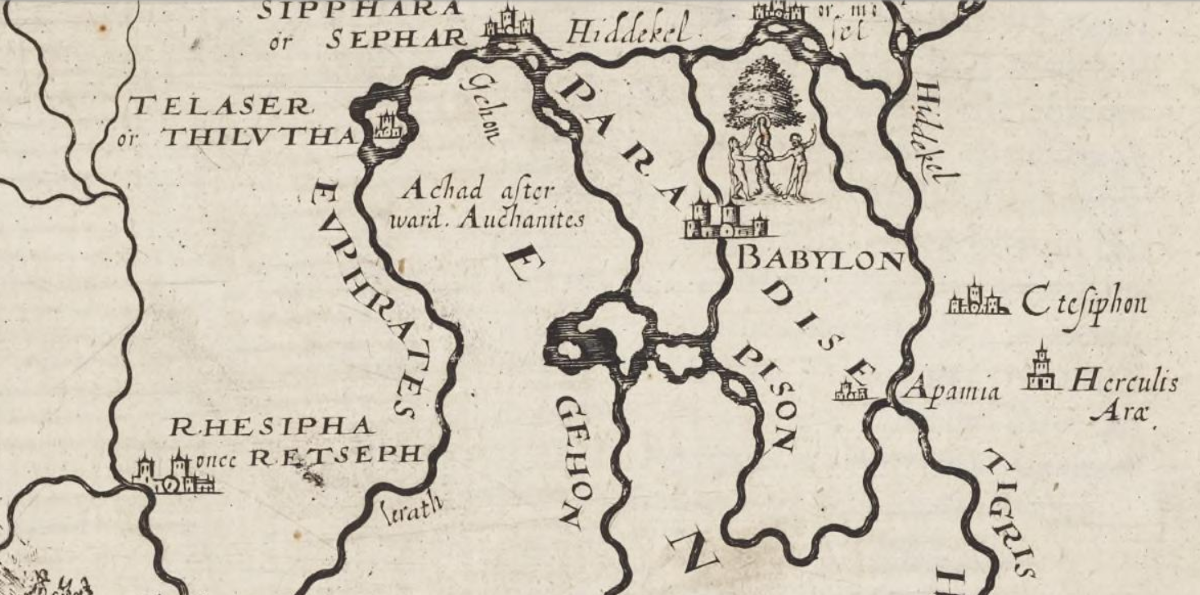
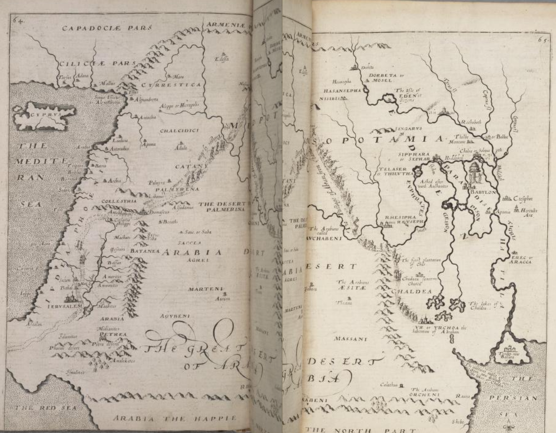
"The Great Desert of Arabia", William Hole's 1614 map of the Middle East issued for Sir Walter Raleigh's "The Historie of the World in Five Bookes" (1614)
(between pages 64 and 65)
Prologue: Journeying to Paradise
At pages 12 & 13
… In 1998, David Rohl claimed that he had found, once and for all and after nearly two millennia of debate, the location of the original Garden of Eden (Figures 0.4 and 0.5) … David Rohl, Legend: The Genesis of Civilisation (1998) at pages 46 to 68. According to Rohl, Adam and Eve's paradise was an agriculturally rich plain some 60 miles wide and 200 long, enclosed by mountain ranges, in north-western Iran, not far from the city of Tabriz. Rohl has also identified, and plotted on a map, the four rivers of Eden that Genesis tells us flowed out of paradise: the Tigris, Euphrates, Gihon and Pishon (2:10-14).
From the time of Augustine (fifth century) to the Renaissance, the most learned scholars in all Europe, Africa and Asia, agreed that the Gihon and the Pishon were the Nile and Ganges, an idea put forward by the first-century Jewish historian Flavius Josephus.
Editor's note: I have dealt with the "strange notion" of Flavius Jospehus in my commentary (above) on Eric Cline's "From Eden to Exile" (2007) the substance of which is again set out here for ease of reference:
Alessandro Scafi's reference to "an idea put forward by the first century [A.D.] Jewish historian Flavius Josephus", makes no mention of the commentary of William Whiston in his "Works of Flavius Josephus" (which includes a translation of Josephus' "The Antiquities of the Jews") in which Whiston queries both the source and the content of Josephus' "strange notion" that "the garden was watered by one river" etc:
- "as if four of the greatest rivers in the world, running two of them at vast distances from the other two, by some means or other watered paradise, is hard to say"
- "Josephus has already appeared to allegorize this history, and take notice that these four names had a particular signification"
- "we perhaps mistake him when we suppose he literally means those four rivers"
- "though what further allegorical sense he had in view, is now, I fear, impossible to be determined"
"The Works of Flavius Josephus" translated by William Whiston and published by Auburn, Alden & Beardsley (1857) at Book 1, Chapter 1, Section 3
[3] Moses says further, that God planted a paradise in the east, flourishing with all sorts of trees; and that among them was the tree of life, and another of knowledge, whereby was to be known what was good and evil; and that when he brought Adam and his wife into this garden, he commanded them to take care of the plants. [5] Now the garden was watered by one river, [6] which ran round about the whole earth, and was parted into four parts. And Phison, which denotes a multitude, running into India, makes its exit into the sea, and is by the Greeks called Ganges. Euphrates also, as well as Tigris, goes down into the Red Sea. [7] Now the name Euphrates, or Phrath, denotes either a dispersion, or a flower: by Tiris, or Diglath, is signified what is swift, with narrowness; and Geon runs through Egypt, and denotes what arises from the east, which the Greeks call Nile.
[5] "The Genuine Works of Flavious Josephus" translated by William Whiston and revised with notes by The Reverend Samuel Burder (1821) published by S. Walker (Boston), Volume 1, Book 1, Chapter 1 at page 12: (1821 & 1849 versions only):
"The place wherein the country of Eden, as mentioned by Moses, seems most like to be situated, is Chaldea, not far from the banks of the Euphrates. To this purpose, when we find Rabshekah vaunting his master's actions, have the gods of the nations delivered them which my fathers have destroyed, as Gazan and Haran, and Rezeph, and the children of Eden, which were in Telassar ? As Telassar, in general, signifies any garrison or fortification, so here, more particularly, it denotes that strong fort which the children of Eden built in an island of the Euphrates, towards the west of Babylon, as a barrier against the incursions of the Assyrians on that side. And therefore, in a11 probability the country of Eden lay on the west side, or rather on both sides the Euphrates, after its conjunction with the Tigris, a little below the place where, in process of time, the famous city of Babylon came to be built. Thus we have found out a country called Eden, which for its pleasure and fruitfulness, as all authors agree, answers the character which Moses gives of it. Herodotus, who was an eye witness of it, tells us, that where Euphrates runs out into Tigris, not far from the place where Ninus is seated, that region is, of all that ever he saw, the most excellent: so fruitful in bringing forth corn, that it yields two hundred fold; and so plenteous in grass, that the people are forced to drive their cattle from pasture, lest they should surfeit themselves." B. (Samuel Burder ?)
[6] Whence this strange notion came, which yet is not peculiar to Joseph, but, as Dr. Hudson says here, is derived from elder authors; as if four of the greatest rivers in the world, running two of them at vast distances from the other two, by some means or other watered paradise, is hard to say. Only since Josephus has already appeared to allegorize this history, and take notice that these four names had a particular signification; Phison for Ganges, a multitude; Phrath for Euphrates, either a dispersion or a flower; Diglath for Tigris, what is swift, with narrowness; and Geon for Nile, what arises from the east; we perhaps mistake him when we suppose he literally means those four rivers; especially as to Geon, or Nile, which arises from the east; while he very well knew the literal Nile arises from the south; though what further allegorical sense he had in view, is now, I fear, impossible to be determined.
[7] By the Red Sea is not here meant the Arabian Gulf, which alone we now call by that name, but all that South Sea, which included the Red Sea, and the Persian Gulf, as far as the East Indies; as Reland and Hudson here truly note, from the old geographers.
"The Works of Flavius Josephus" translated by William Whiston and published by Auburn, Alden & Beardsley (1857) at Book 1, Chapter 1, Section 2
[2] Moreover, Moses, after the seventh day was over, begins to talk philosophically; [8] and concerning the formation of man, says thus: That God took dust from the ground, and formed man, and inserted in him a spirit and a soul … [9]
[8] Since Josephus, in his Preface, section 4, says that Moses wrote some things enigmatically, some allegorically and the rest in plain words, since in his account of the first chapter of Genesis and the first three verses of the second, he gives us no hints of any mystery at all; but when he here comes to verse 4 &c he says that Moses, after the seventh day was over, began to talk philosophically, it is not (very - 1857) improbable that he understood the rest of the second and the third chapters in some enigmatical, or allegorical or philosophical sense. The change of the name of God just at this place from Elohim to Jehovah Elohim, from God to Lord God, in the Hebrew, Samaritan and Septuagint, (also seems to favour - 1821) (does also not a little favour - 1857) some such change in the narration or construction.
[9] We may observe here that Josephus supposed man to he compounded of spirit, soul and body, with St. Paul, I Thessalonians v. 23 (And the very God of peace sanctify you wholly; and I pray God your whole spirit and soul and body be preserved blameless unto the coming of our Lord Jesus Christ) and the rest of the ancients: he elsewhere says also, that the blood of animals was forbidden to be eaten, as having in it soul and spirit. Antiquities, Book iii, Chapter xi, Section 2.
Editor's note: In summary, regardless of whether or not "the most learned scholars in all Europe, Africa and India" in mediæval times adopted this "strange notion" of Flavius Josephus, his random enigmatic, allegorical, philosophical and "plain words" narration is unhelpful "in determining where the Garden of Eden was located".
"This errour that Pison was Ganges was first broched by Josephus, (whose fields though they be fertile, yet are they exceeding full of weedes) and other men (who take his authoritie to be sufficient in matter of description, whereupon depended no other important consequence) were not curious in the examination thereof." per "The Historie of the World in Five Bookes" (1614) Sir Walter Raleigh, Chapter 3 Section 13 (Of the River Pison, and the land of Havilah) at lines 16 to 19 on page 59
By way of analogy, in astronomy the geocentric model is a superseded description of the universe with Earth at the centre. Under the geocentric model, the Sun, Moon, stars, and planets all orbited Earth. The geocentric model served as the predominant description of the cosmos in many ancient civilizations, such as those of Aristotle (4th century B.C.) [10] and Ptolemy (2nd century A.D.). Although the basic tenets of Greek geocentrism were established by the time of Aristotle, the details of his system did not become standard. The Ptolemaic system, developed by the Hellenistic astronomer Claudius Ptolemæus in the 2nd century A.D. finally standardised geocentrism. For over a millennium European and Islamic astronomers assumed it was the correct cosmological model. The geocentric model held sway into the early modern age, but from the late 16th century onward it was gradually superseded by the heliocentric model of Copernicus, Kepler and Galileo. There was much resistance to the transition between these two theories. Christian theologians were reluctant to reject a theory that agreed with Bible passages (e.g. "Sun, stand you still upon Gibeon", Joshua 10:12). Others felt a new, unknown theory could not subvert an accepted consensus for geocentrism.
[10] See Book II, Chapter 13, lines 20-22 of Aristotle's De Cælo ("On the Heavens") written in 350 B.C.: "The observed facts about earth are not only that it remains at the centre, but also that it moves to the centre." (eBook available here).
The "strange notion" of Flavius Josephus and Aristotle's geocentric model (standardised by Claudius Ptolemæus) both prevailed for two millennia [11] before being abandoned during the Renaissance such that the rivers Gihon and Pishon can no longer be considered to be references to, respectively, the rivers Nile and Ganges.
[11] The geocentric model prevailed for a period in excess of 2,178 years from circa 546 B.C. - the approximate date of Anaximander's Gês períodos ("Rotation of the Earth") - to 1632, being the date of publication by Galileo Galilei of his Dialogo sopra i due massimi sistemi del mondo ("Dialogue Concerning the Two Chief World Systems") in support of heliocentrism as described in De revolutionibus orbium cœlestium ("On the Revolutions of the Heavenly Spheres") published in 1543 A.D. by Nickolaus Copernicus.
According to Rohl, however, the Gihon and Pishon are two rivers in Azerbaijan and Kurdistan, which flow into the Caspian Sea: the Araxes, known before the Islamic invasion of the eighth century as the Gaihun (the linguistic equivalent of the Hebrew Gihon), and the Uizhon (a variation on the Hebrew Pishon). Rohl also identifies the biblical land of Cush (across which, according to Genesis, the Gihon flows) as the range of the Kusheh Dagh, sited about 100 miles east along the valley in which his Garden of Eden is situated, and claims to have discovered the single river (unnamed in the Bible) that watered the Garden, identifying it with the Adi Chay. A village called Noqdi is a relict of the land of Nod, the land to the east of Eden to which, according to Genesis, Cain was exiled after murdering his brother Abel (4.16). Havilah, described in Genesis as a place rich in gold and surrounded by the Pishon, is in Rohl's opinion in Kurdistan, where there used to be, it is true, a couple of gold mines.
The case of Rohl confirms that the story of the biblical paradise has lost none of its appeal over the centuries. The fertile paradise of Genesis remains in the memory in other ways too … But it is not only in the theatre or in the churches that the words 'paradise' and 'Eden' are still rehearsed. The two words are common currency in a diversity of contexts … Whichever way we turn, we come across echoes of the ancient story of Adam and Eve in paradise.
The history of Christian belief in an earthly paradise fully merits exploration. Paradise has appeared in almost every form of cultural expression: poetry, visual art, literary and philosophical writing. It has also appeared on maps, and Rohl's map is only one of the latest in a long series of attempts to locate paradise cartographically. Maps offer the historian of ideas a peculiarly valuable point of entry for rediscovering a forgotten world where the notion of an earthly paradise was never irrational, absurd or trivial, but always predicated on belief and knowledge. The enterprise of depicting paradise on a map of the world, or part of the world, has for centuries involved a major intellectual challenge. The mapping of the earthly paradise, the history of heaven on earth as depicted on maps from Late Antiquity to the twenty-first century, is the subject of this book.
At page 14
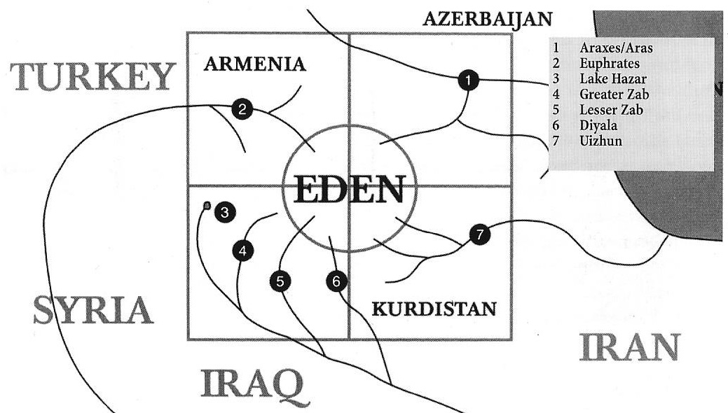
Figure 0.4: The four rivers of Paradise
Figure 0.4: The four rivers of paradise flowing out from the the four quarters of Eden, from David Rohl's "Legend: The Genesis of Civilisation" (1998). Rohl announces his intention to venture 'where others fear to tread' in order to explain 'one of the most difficult of puzzles handed down to us from the ancient world'. After acknowldeging his debt to the scholar Reginald Arthur Walker (1917-89), Rohl established the identities of the four rivers of paradise, showing that they all flow in Armenia. Both the Pishon (which he identifies with the Uizhon, in the south-east of the map, no. 7 on the map) and the Gihon (identified with the Araxes, in the north-east, no. 1) flow into the Caspian Sea. The Tigris (whose main source rises in Lake Hazar, no. 3, and which receives the waters of the Greater and the Lesser Zab and the Diyala, nos. 4, 5 and 6 respectively, in the south-western sector) and the Euphrates (in the north-western sector, no. 2) empty into the Persian Gulf.
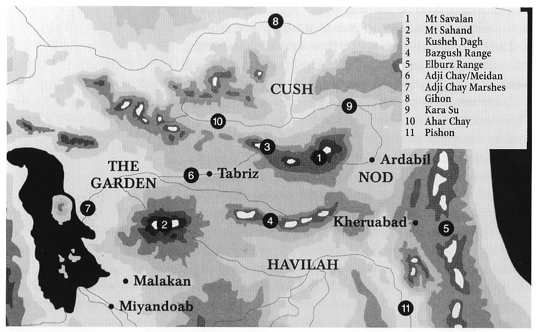
Figure 0.5: Relief map showing the location of the Garden of Eden and the lands of Cush and Havilah
Figure 0.5: Simplified relief map showing the location of the Garden of Eden and the lands of Cush and Havilah, from David Rohl, "Legend: The Genesis of Civilisation" (1998). Rohl identifies the biblical Eden with the Adji Chay valley (formerly known as the Meidan valley) in north-west Iran, at the heart of which is the regional capital of Tabriz. The Garden is 'in the east of Eden', protected on its north, east and south sides by the Savalan (no. 1) and Sahand (no. 2) mountains, and on its west side by the marshy delta of the Adji Chay (no. 7), which stretches out into Lake Urmia. To the north of the Garden lies the Kusheh Dagh ('Mountain of Kush'. no. 3). Havilah is south of the Bazgush range (no. 4), in the Iranian district of Anguran, renowned for its mineral wealth. The town of Kheruabad (the 'settlement of the Kheru') possibly owes its name to the Cherubim, the angels guarding Eden (Genesis 3.24), the destination of Cain's exile, is in the plain west of the Elburz mountains (no.5) around the city of Ardabil.
At pages 369 & 370
… None of those 'last words' on the location of paradise was ever effectively final. Even as they rehearsed again and again the list of 'ridiculous' earlier opinions, Renaissance writers were generating a new flowering of 'imaginative' theories, those surveyed in Chapter 10, which differ from medieval theories mainly in searching for a lost paradise. The paradigm shift has not, however, put an end to the search for a lost paradise. The idea with which this book started, David Rohl's suggestion in 1998 (now recognizable as a variant of Calmet's idea) that Eden was in north-west Iran has been taken up by The Sunday Times (Peter Martin, 'The Secret Garden', Sunday Times Magazine (11 October 1998) pages 44-50). 'Hardy travellers' who accepted the invitation to sign up with a travel agency for the journey of a lifetime to the Garden of Eden would have enjoyed the wealth of archæological features, but would not have found the biblical terrestrial paradise that they could re-enter. A similar disppaointment must have been experienced by the nineteenth-century English explorer, William Heude, who, on 19 January 1817, reached the confluence between the Tigris and the Euphrates, as he journeyed from India to Arabia …
At page 371
… It is clear that no surviving biblical earthly paradise will be found or mapped. A paradise in heaven, though, may still be mapped for the religious.
Recent Research
"Humans 100,000 years older than thought"
By Sarah Knapton, Science Editor, The Daily Telegraph, Thursday 8th June 2017
Human evolution began at least 100,000 years earlier than previously thought, scientists have found, debunking the theory that the Rift Valley of Ethiopia was the "cradle of mankind".
The world's oldest Homo sapiens fossils - which may represent the first known human family - have been excavated in a barite mine at Jebel Irhoud, 60 miles west of Marrakesh, dating between 300,000 and 350,000 years old.
Until now, experts believed that all humans descended from a population in east Africa. The earliest examples of our species were found in the Sixties by Richard Leakey in south-west Ethiopia, dating from 195,000 years ago.
But the new fossils - of three young adults, one adolescent and a child of around eight - prove that early modern humans were established at Jebel Irhoud at least 300,000 years ago.
"There is this notion that somewhere in east Africa there is a Garden of Eden where our species first developed," said Prof Jean-Jacques Hublin, of the Max Planck Institute for Evolutionary Anthropology in Leipzig.
| "Very early in the process we realised the site was much older than anyone could imagine and we came to the conclusion that the layer richest in hominids around the site was much older than anything else in Africa. This material represents the very root of our species. So there is no Garden of Eden in Africa. Or, if there is, it is the whole of Africa." |
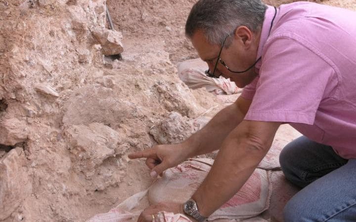
Prof Jean-Jacques Hublin pointing to the crushed human skull whose orbits are visible just beyond his finger tip
Fossil remains were first discovered by miners working at the Jebel Irhoud in the 1960s, who while digging a new gallery, hit a pocket of reddish sediment which collapsed, revealing stone artefacts, bone and a skull. But initial dating suggested they were only 40,000 years old. However experts were puzzled by the features of the bones which had some modern human traits, but also more ancient brain cavities. So in 2004, experts at the Max Plank Institute began a painstaking new excavation to hunt for new fossils and re-date the stone tools using the latest scientific methods.
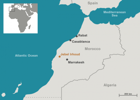
Using state-of-the-art scans and statistical shape analysis based on hundreds of measurements the experts were able to recreate a computer-generated image of the original face of one of the fossils, and found it was virtually indistinguishable from that of modern humans living today. The only difference was a slightly more elongated braincase, which would have held a different shaped brain.
Reporting their findings at a press briefing, Prof Hublin said:
"It's not just that we have an older date for the older forms of Homo sapiens but also it allowed us to envision a rather more complex picture for the emergence of our species with different parts of our anatomy evolving at different rates. There is an idea that humans like us appeared rather quickly but our results show this is very unlikely to be true. The story of our species in the last 300,000 years is mostly the evolution of our brain."
Dr Philipp Gunz, of the Max Plank Institute added:
"Our findings suggest that modern human facial morphology was established early on in the history of our species, and that brain shape, and possibly brain function, evolved within the Homo sapiens lineage."
The fossils were found in deposits containing animal bones showing evidence of having been hunted, with the most frequent species being gazelle. By looking at the animals present, archæologists were able to recreate the landscape and climate from the time, to give a picture of the environment for our early ancestors.
"Conditions were wetter than they were today, a little bit more humid, a landscape that is still open but with some clumps of trees, a sort of mixed environment," added Max Planck Institute archæologist Shannon McPherron. "The site itself is in a hill and at the time of occupation would have been a cave, would have provided shelter and we found animal bones and stone tools which they would have used to process and consume those animals. We also find evidence of the fires that they had and the overall picture that one gets is a kind of hunting encampment, a place where people were passing through the landscape and spending the night, taking shelter there in search of subsistence."
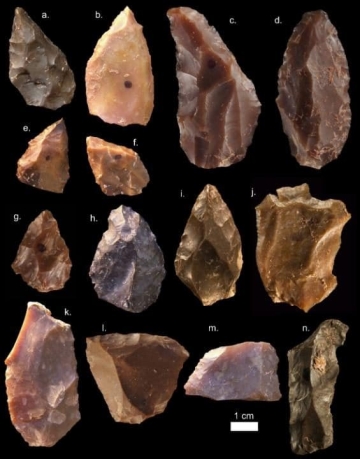 |
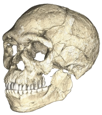 |
| Some of the Middle Stone Age stone tools from Jebel Irhoud | A composite reconstruction of the earliest known Homo sapiens fossils from Jebel Irhoud |
The discoveries were reported in the journal Nature.
The age of the hominin fossils from Jebel Irhoud, Morocco, and the origins of the Middle Stone Age
Nature, Wednesday 7th June 2017
Published online by Daniel Richter, Rainer Grün, Renaud Joannes-Boyau, Teresa E. Steele, Fethi Amani, Mathieu Rué, Paul Fernandes, Jean-Paul Raynal, Denis Geraads, Abdelouahed Ben-Ncer, Jean-Jacques Hublin & Shannon P. McPherron
The timing and location of the emergence of our species and of associated behavioural changes are crucial for our understanding of human evolution.
The earliest fossil attributed to a modern form of Homo sapiens comes from eastern Africa and is approximately 195 thousand years old, therefore the emergence of modern human biology is commonly placed at around 200 thousand years ago.
The earliest Middle Stone Age assemblages come from eastern and southern Africa but date much earlier. Here we report the ages, determined by thermoluminescence [4] dating, of fire-heated flint artefacts obtained from new excavations at the Middle Stone Age site of Jebel Irhoud, Morocco, which are directly associated with newly discovered remains of Homo sapiens.
A weighted average age places these Middle Stone Age artefacts and fossils at 315 ±34 thousand years ago. Support is obtained through the recalculated uranium series with electron spin resonance date of 286 ±32 thousand years ago for a tooth from the Irhoud 3 hominin mandible. These ages are also consistent with the faunal and microfaunal assemblages and almost double the previous age estimates for the lower part of the deposits.
The north African site of Jebel Irhoud contains one of the earliest directly dated Middle Stone Age assemblages, and its associated human remains are the oldest reported for Homo sapiens. The emergence of our species and of the Middle Stone Age appear to be close in time, and these data suggest a larger scale, potentially pan-African, origin for both.
[4] Thermoluminescence: frequently asked questions
- How does thermoluminescence dating work ?
- Thermoluminescence dating of burnt flint artifacts
- What is the accuracy of thermoluminescence dating ?
- What materials can be dated by thermoluminescence ?
- Warning about fakes using ancient materials
- How is a sample taken ?
How does thermoluminescence dating work ?
The thermoluminescence (TL) technique is the only physical means of determining the absolute age of pottery presently available. It is an absolute dating method, and does not depend on comparison with similar objects (as does obsidian hydration dating, for example). In archæology TL is mainly used for pottery analysis whilst in anthropology the main use of TL is the dating of flint stone as early tool material for mankind.
TL originates from the temperature-induced release of energy, stored in the lattice structure of the crystal following long-term internal and external exposure to nuclear radiation from natural sources. TL accumulates in the material with time depending on the radiation (and light) exposure. The TL is released by heating. The dating clock starts with the initial firing of the material, when originally accumulated TL is being driven out.
Most mineral materials, including the constituents of pottery, have the property of TL, where part of the energy from radioactive decay in and around the mineral is stored (in the form of trapped electrons) and later released as light upon strong heating (as the electrons are released and combine with lattice ions). By comparing this light output with that produced by known doses of radiation, the amount of radiation absorbed by the material may be found.
When pottery is fired, it loses all its previously acquired TL, and on cooling the TL begins again to build up. Thus, when one measures dose in pottery, it is the dose accumulated since it was fired, unless there was a subsequent reheating. If the radioactivity of the pottery itself, and its surroundings, is measured, the dose rate, or annual increment of dose, may be computed. The age of the pottery, in principle, may then be determined by the relation:
| age = palæodose / annual dose |
Although conceptually straightforward, TL has proven to be far from simple in practice. In all, close to two dozen physical quantities must be accurately measured to establish the relationship between doses of different kinds of radiation and light output, and to compute dose rate.
The phenomenon of TL was first described by the English chemist Robert Boyle in 1663. It was employed in the 1950s as a method for radiation dose measurement, and was soon proposed for archæological dating. By the mid-1960s, its validity as an absolute dating technique was established by workers at Oxford and Birmingham in England, Risø in Denmark, and at the University of Pennsylvania in the USA. The Research Laboratory for Archæology at Oxford, in particular, has played a major role in TL research.
While not so accurate as radiocarbon dating, which cannot date pottery (except from soot deposits on cooking pots), TL has found considerable usefulness in the authenticity of ceramic art objects where high precision is not necessary.
Thermoluminescence dating of burnt flint artifacts
Our ancestors have been making flint tools for over a million years. The tools or the flakes left by the flint-knappers have become important markers of prehistoric habitats. The imperishable and ubiquitous nature of flint (chert, hornstone, quartzite, etc - the term 'flint' is used here as a general descriptor of material composed of SiO² with a low crystallinity index)) explains why generations of prehistorians have used it to build a stone age chronology. To be dateable by TL flint must be heated to at least 450°C. While human use of fire may be as old as half a million years, the first true hearths appear late during the Lower Palæolithic period. By the dawn of the Middle Palæolithic fire must have become fully domesticated, judging by the accumulations of charred debris that henceforth litter human habitats.
Establishing chronologies is crucial for Palæolithic research. The lack of chronometric ages for a given site often makes it difficult to place it within the time frame provided by chronostratigraphy and palæoclimatology. TL dating of burnt flint is frequently used to determine the age of Palæolithic sites. It is a dosimetric dating method, which employs the accumulation of radiation damage in crystal lattices through time. Flint artifacts can be dated by TL methods if they have been heated in a prehistoric fire to about 400°C. The TL-age estimate refers to the last heating and therefore provides a direct date for a prehistoric event. Naturally occurring fires are unlikely to be responsible for the heating of material in the vast majority of Palæolithic sites and, in any event, the penetration depth of fire in sediment is very low and burning roots do not produce high temperatures. It is thus unlikely that artifacts were heated by natural fires to an extend required for successful TL-dating application in most cases.
Sample sizes for standard procedures require pieces of at least 10-15 g. A new TL-dating technique has been developed which uses only a few mg of material, thus reducing the minimum sample size to a few grams only, and allows the chronometric dating of sites which do not provide sample material for standard dating approaches: see "Burnt flint artifacts: a new thermoluminescence dating technique", Hugo Obermaier Society, 49th Annual Meeting in Trento (10th - 14th April, 2007)
What is the accuracy of thermoluminescence dating ?
Studies at Oxford back in the 1970s on Romano-British pottery indicated that when all quantities entering the age equation are measured, the TL date of a single potsherd will typically fall within 15% of the known date. When dates of a number of sherds associated together are averaged, the error is reduced typically to 7-10%. This is for well-behaved samples only. The succeeding 30 years, and increased understanding of the dosimetry, have not brought much improvement.
Generally speaking, when a sample is drilled and there is no information available about the burial environment, one may expect up to 40% uncertainty. This is adequate for the purposes of authentication where the question is whether the piece was fired in antiquity or recently; it will not differentiate, say, between a classic Greek terra cotta and a Roman copy. In some categories of objects, from China, for example, the actual age is quite precisely known for short-lived styles, and it is possible to work "backwards" to get information about the environment in many parts of the world, and some other parameters not usually measurable for art objects. Using this information often reduces the uncertainty to 15-25%.
What materials can be dated by thermoluminescence ?
Nearly any mineral material which has been heated above 500°C at a time one wishes to know is a candidate for TL dating. This includes all forms of pottery. Porcelains, being nearly vitrified, are a special case requiring a fairly large solid core sample, and TL dating of intact objects is not recommended because of the damage caused by sampling. Most porcelain dating is done for insurance purposes on broken objects. Much stoneware is not so hard as porcelain and may be sampled by drilling. The clay cores from lost wax metal castings may readily be tested. Heated stone material, such as hearths, pot boilers, and burnt flints, has been dated as well.
Warning about fakes using ancient materials
Recently there has been a spate of forgeries devised expressly to attempt circumventing TL dating. These use pottery of the appropriate period to construct objects. Some of these are quite easy to detect; some quite difficult. For example figures, normally modeled, may be carved out of brick or assembled out of fragments. These will give an 'authentic' date for a bogus object. It must be realized that TL dating is but one of the criteria for judging authenticity. The expertise of the conservator may be of equal or greater importance in many cases. Some problem areas include Northern Nigerian ceramics, especially Nok, which are becoming quite scarce. Ife ceramics are virtually all fake (or stolen, if genuine), but some heads are made from old pot fragments (often too old). New Nigerian (and Asian) bronzes may have introduced old cores, so it is imperative that the interface between metal and core be examined very carefully before the assumption can be made that the age of the bronze is the age of the core. Chinese unglazed ceramics constructed from fragments (or carved from brick) are a particular concern.
How is a sample taken ?
When the TL test is for routine authentication, a sample of about 100mg, roughly a third the volume of a pencil-end eraser, is drilled out of an inconspicuous part of the object with a carbide dental burr. If the object is extremely small, the amount of sample may be reduced, but the error margin may increase. It is sometimes preferable to obtain a fragment a half-inch in diameter and a quarter-inch thick, as the precision attainable is greater. This is advisable whenever the age, if genuine, is less than twice the age of the earliest forgeries.
Sampling does not lessen the value of a piece; indeed, confirmation of authenticity by TL generally enhances an object's value and saleability considerably. The site of the samples may easily be restored.
New fossil discovery rewrites history of first human beings
By Joel Hruska, Wednesday 7th June 2017, Extremetech
Previously, the earliest fossil remains of anatomically modern humans (AMH) were found in Ethiopia and dated to circa 200,000 years ago. Many other AMH fossils have been found in the same areas of Africa, and the scientific consensus has been that these finds represented the first appearance of modern humans. This single origin hypothesis isn't the only theory for how humanity first emerged and then spread across the continent and planet, but it's been the most common argument for a number of years. These new finds, located in Morocco, challenge the existing narrative. It was believed that humanity spread across Africa for over a hundred thousand years before traveling to new continents roughly 70,000 years ago.
This new work is from a site named Jebel Irhoud, where excavations have been ongoing for decades. Part of what sets them apart is that the research team isn't working from just one skull or bone fragments from a single individual, but a group of five separate people. Dr. Hublin and his colleagues used a technique known as thermoluminescence, a technique that measures the accumulated radiation dose of objects that have previously been heated or exposed to sunlight to measure how old they are. The degree of luminescence is proportional to the radiation dose absorbed by the material in question.
In this case, the dating method established that flint blades buried at the site had been burned, probably through exposure to cooking fires, roughly 300,000 years ago. The skulls the expedition found were in the same rock layer as the flint blades, which strongly implies they date to roughly the same time period.
… The humans who lived at Jebel Irhoud could start fires and craft spears. The flint that they used for their weapon tips wasn't local to the area, but came from a site some 20 miles south of Jebel Irhoud. This suggests that early humans knew how to find resources and utilize them even when said resources were scattered rather than grouped in a single location. That's significant in and of itself, particularly for remains as unusual as these.
So how do these finds, assuming they prove to be accurately dated and to belong to our own species, change our understanding of human evolution? They suggest, at minimum, that Homo sapiens sapiens was around much earlier than we previously thought it was. Whether our species evolved in a single specific location or more generally across the continent is still unclear. And not every scientist agrees with Gunz and Hublin that the Jebel Irhoud bones are clear evidence for AMHs more than 100,000 years before they were previously thought to have emerged.
"Homo sapiens 100,000 years older than thought"
Evolution of modern humans pushed back to 300,000 years ago, based on fossils from Morocco
By Clive Cookson, Science Editor, Financial Times, Wednesday 7th June 2017
The origins of our species Homo sapiens lie at least 100,000 years earlier than believed. Palæontologists have found 300,000-year-old Homo sapiens fossils in Morocco, a discovery that not only pushes the evolution of modern humans further back but also focuses research into human origins on a new part of Africa.
Jean-Jacques Hublin, the project leader, said:
"We used to think there was a cradle of mankind 200,000 years ago in east Africa but our new data reveal that Homo sapiens spread across the entire African continent around 300,000 years ago."
The research is published in Nature.
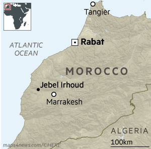
The fossils come from Jebel Irhoud, west of Marrakesh, which was originally investigated in the 1960s and has been re-examined with new dating technology that shows the site is far older than the original archæologists believed. The human bones excavated represent three young adults, an adolescent and a small child. They include a partial skull and lower jaw but no pelvis or lower limbs. Computerised reconstruction of the skulls shows that the inhabitants of Jebel Irhoud would have looked remarkably similar to humans today.
"Their face is the face of people you could meet in the street now," said Professor Hublin, of the Max Planck Institute for Evolutionary Anthropology in Leipzig. "Wearing a hat they would be indistinguishable to us."
He mentioned a hat because, in contrast to a modern face and jaws, the Jebel Irhoud skulls look more archaic from the back, with a lower and more elongated brain case. "Our findings suggest that modern human facial morphology was established early on in the history of our species, and that brain shape and possibly brain function evolved within the Homo sapiens lineage," said Philipp Gunz at the institute.
Jebel Irhoud 300,000 years ago was open grassland with plentiful game. The archæological site contains bones of animals, particularly gazelles, which show signs of having been hunted. There is evidence too of fires being used for cooking and keeping warm.
Stone tools excavated at the site are typical of what palæontologists call the Middle Stone Age. The tools were made mainly of high-quality flint that does not occur locally but would have been brought in from 20 miles away. Their pointed form suggests they were attached to a handle, perhaps to use as spears for hunting.
"The stone artefacts from Jebel Irhoud look very similar to ones from deposits of similar age in east Africa and in southern Africa," said Shannon McPherron, another member of the team. "It is likely that the technological innovations of the Middle Stone Age in Africa are linked to the emergence of Homo sapiens."
Previously, the oldest reliably dated Homo sapiens fossils were 195,000-year-old bones from Omo Kibish in Ethiopia. But researchers at the institute said the Jebel Irhoud discoveries corroborate the controversial interpretation of a 260,000-year-old partial cranium from Florisbad, South Africa, as being an early Homo sapiens.
Prof Hublin said if Homo sapiens was widely distributed across Africa 300,000 years ago, more research was needed to estimate how long ago the species emerged from earlier hominids such as Homo heidelbergensis.
"There is a maximum age beyond which we cannot go: the split between Homo sapiens and Neanderthals around 650,000 years ago," he added.
Chris Stringer, human origins expert at London's Natural History Museum, who was not involved in the Jebel Irhoud work, said
"It shifts Morocco from a supposed backwater in the evolution of our species to a prominent position."
The world 300,000 years ago would have been populated with several human species, including a diversity of early Homo sapiens forms across Africa, the recently discovered Homo naledi in South Africa, Homo heidelbergensis survivors in central Africa, and Neanderthals and Denisovans in Eurasia, as well as the mysterious human hobbits in Flores, Indonesia.
"Real location of 'Garden of Eden' cast into doubt by oldest Homo sapiens fossils ever found"
Modern humans evolved about 100,000 years earlier than previously thought, researchers say.
By Ian Johnston, Science Correspondent, The Independent, Thursday 8th June 2017
Modern humans evolved about 100,000 years earlier than previously thought and may not have first emerged in a 'Garden of Eden' in east Africa, scientists have said after dating fossils found in the mountains of Morocco. Until now, it was believed Homo sapiens developed about 200,000 years ago in what is now Ethiopia. But the dating of finds at Jebel Irhood, about 60 miles west of Marrakesh, to about 300,000 years ago suggests our species evolved in a more complex way.
In addition to being the oldest known remains of modern humans, the fossils, which include skulls, corroborate a fragment found in South Africa that had been tentatively dated to 260,000 years ago. This suggests that Homo sapiens evolved from a variety of different types of Hominins which once existed across Africa.
The finds at Jebel Irhood, a well-known site first exposed by mining operations in the 1960s, also indicate that the Stone Age people who lived there were prolific hunters, living on a diet of gazelles, zebras, buffalos and wildebeests. Professor Jean-Jacques Hublin, a palæoanthropologist at the Max Planck Institute for Evolutionary Anthropology in Germany, said:
"In the last 20 years, the consensus has been that very likely our species emerged somewhere around 200,000 years ago and probably the first forms of what we call early modern humans were represented in East Africa. There is this notion that somewhere in sub-Saharan Africa there is this sort of ‘Garden of Eden' where our species first developed, then spread inside Africa and outside of Africa. Our results challenge this picture."
The Moroccan fossils, coupled with those in East Africa and South Africa, suggest that Homo sapiens "spread across the entire African continent around 300,000 years ago", he said.
"Long before the out-of-Africa dispersal of Homo sapiens, there was dispersal within Africa", he added.
The researchers said they were trying to work out why the world came to be dominated by one "extremely successfully" type of human, when once there had been a number of different types, such as Neanderthals, Denisovans and the recently discovered "hobbits", living alongside each other in Africa, Europe and Asia.
"What made our species so special, that this species expanded out of Africa at some point and replaced other groups of Hominins", Professor Hublin said.
The fossils found at Jebel Irhood show the people had a modern-looking face and teeth. They also had a large braincase, but its shape had similarities with earlier types of humans. However, writing in the journal Nature, the researchers said the fossils displayed the "early stages of the Homo sapiens clade in which key features of modern morphology were established".
The site was discovered during mining operations in the 1960s and initially the fossils were not thought to be anywhere near as old. But modern techniques dated fire-heated flint artefacts found alongside them to about 315,000 years ago and a tooth from one individual to about 286,000 years ago, both estimates had a margin of error of more than 30,000 years.
Professor Rainer Grün, who helped date the fossils, described how quickly our understanding of human evolution had changed over the last few decades.
"If we look at the history of human evolution, until the mid-80s it was thought model humans evolved in Africa and shortly after migrated to Europe at around 40,000 years. In the late 80s there were the first results of anatomically modern humans in Israel at about 100,000 years," he said. "In the 90s there were a few sites found in Ethiopia dated to 200,000 years and now with these results the origins of modern humans are further pushed back to 300,000 years." But the Jebel Irhoud finds meant "we now have to rethink a number of principles within human evolution", he added.
One reason why understanding early human evolution has been so difficult is that Homo sapiens do not appear to have buried their dead around this time. Professor GrÜn, director of the leading Australian Research Centre for Human Evolution, said:
"The finds in Jebel Irhoud are one of the few places we've found modern skulls. That's why our understanding of human evolution is very patchy because we find so few human remains. In contrast, Neanderthals buried their dead but they ate them as well, leading to bone accumulations in caves."
Among the remains were animal bones with tell-tale cuts made by human butchery techniques. Some bones were broken open so the people could eat the nutritious marrow. Most of the bones were from gazelles but the remains of hartebeests, wildebeests, zebras, buffalos, porcupines, hares, tortoises, freshwater molluscs, snakes and ostrich egg shells were also identified. Small game made up only a small percentage of the bones.
"It really seemed like people were fond of hunting," said Professor Teresa Steele, of University of California, Davis, who analysed animal fossils at Jebel Irhoud. Commenting on the research, Professor Robert Foley, an expert in human evolution at Cambridge University, told The Independent that the researchers had made "an important contribution to understanding modern human origins".
"While we have abundant evidence for the existence of modern humans in and around Africa around 100,000 years ago, the early stages are very poorly known - only two fossil sites, both from Eastern Africa," he wrote in an email. "While we have known about Jebel Irhoud for a long time, the new material is important and the new date extremely interesting. The morphology confirms what we see also in Herto and Omo Kibbish [sites in East Africa], namely that the earliest modern humans show some key derived features, but also retain more archaic ones," he said. "Combine this observation with the existence in other parts of Africa from 350,000 to 150,000 years ago of more archaic populations, then we have to think of Africa at this time as a mosaic of Hominin populations, a network of gene flow and isolation, from which, in the end, tens of thousands of years later, one form becomes predominant. Unravelling how that happened remains a big challenge. While this does not necessarily indicate a particular region of origin, it shows that similar populations were widely distributed across Africa."
An 85,000-year-old finger fossil may challenge theories about how early humans migrated from Africa
By Meagan Flynn, The Washington Post, Tuesday 10th April 2018
The 85,000-year-old finger fragment was about as big as a piece of Lego, but the archaeologists who found it buried in the Saudi Arabian desert say it's among a slew of recent discoveries that may challenge our understanding of how early humans first migrated out of Africa.
Archæologists from the Max Planck Institute for the Science of Human History in Germany announced the discovery of the fossilized finger on Monday. They described it as the oldest directly dated Homo sapiens fossil found outside of Africa or the southwest Asian region called the Levant, or modern-day Israel and Syria. The finding, published April 9 in the Nature, Ecology and Evolution journal, "joins a small but growing corpus of evidence" suggesting humans may have migrated from Africa much earlier and farther than previously thought, the archæologists said.
| Summary: Understanding the timing and character of the expansion of Homo sapiens out of Africa is critical for inferring the colonization and admixture processes that underpin global population history. It has been argued that dispersal out of Africa had an early phase, particularly ~130-90 thousand years ago (ka), that reached only the East Mediterranean Levant, and a later phase, ~60-50ka, that extended across the diverse environments of Eurasia to Sahul. However, recent findings from East Asia and Sahul challenge this model. Here we show that Homo sapiens was in the Arabian Peninsula before 85ka. We describe the Al Wusta-1 (AW-1) intermediate phalanx from the site of Al Wusta in the Nefud desert, Saudi Arabia. AW-1 is the oldest directly dated fossil of our species outside Africa and the Levant. The palaeoenvironmental context of Al Wusta demonstrates that Homo sapiens using Middle Palæolithic stone tools dispersed into Arabia during a phase of increased precipitation driven by orbital forcing, in association with a primarily African fauna. A Bayesian model incorporating independent chronometric age estimates indicates a chronology for Al Wusta of ~95-86ka, which we correlate with a humid episode in the later part of Marine Isotope Stage 5 known from various regional records. Al Wusta shows that early dispersals were more spatially and temporally extensive than previously thought. Early Homo sapiens dispersals out of Africa were not limited to winter rainfall-fed Levantine Mediterranean woodlands immediately adjacent to Africa, but extended deep into the semi-arid grasslands of Arabia, facilitated by periods of enhanced monsoonal rainfall. |
| Discussion: AW-1 is the oldest directly dated Homo sapiens fossil outside Africa and the Levant. It joins a small but growing corpus of evidence that the early dispersal of Homo sapiens into Eurasia was much more widespread than previously thought. The site of Al Wusta is located in the Nefud desert more than 650 km southeast of Skhul and Qafzeh. This site establishes that Homo sapiens were in Arabia in late MIS5, rather than being restricted to Africa and the Levant as suggested by traditional models. With Skhul dating to ~130-100 ka, Qafzeh to ~100-90 ka and Al Wusta to ~95-85 ka, it is currently unclear whether the southwest Asian record reflects multiple early dispersals out of Africa or a long occupation during MIS5. The association of the Al Wusta site with a late MIS5 humid phase suggests that significant aspects of this dispersal process were facilitated by enhanced monsoonal rainfall. While changes in behaviour and demography are crucial to understanding the dispersal process, climatic windows of opportunity were also key in allowing Homo sapiens to cross the Saharo-Arabian arid belt, which often constituted a formidable barrier. |
| Conclusion: Al Wusta shows that the early, MIS5, dispersals of Homo sapiens out of Africa were not limited to the Levantine woodlands sustained by winter rainfall, but extended deep into the Arabian interior where enhanced summer rainfall created semi-arid grasslands containing abundant fauna and perennial lakes. After long being isolated in Africa, our species expanded into the diverse ecologies of Eurasia in the Late Pleistocene. Within a few thousand years of spreading into Eurasia, our species was occupying rainforest environments and making long sea crossings to remote islands. Adapting to the semi-arid conditions of the Saharo-Arabian arid belt represented a crucial step on this pathway to global success and the Al Wusta Homo sapiens fossil demonstrates this early ability to occupy diverse ecologies that led to us becoming a cosmopolitan species. |
Michael Petraglia of the Max Planck Institute said in a statement:
"The Arabian Peninsula has long been considered to be far from the main stage of human evolution. This discovery firmly puts Arabia on the map as a key region for understanding our origins and expansion to the rest of the world."
The 'textbook theory' about migration from Africa is that Homo sapiens didn't move on until about 60,000 years ago, mostly in a single wave of migrants along the African coast, Huw Groucutt, the article's lead author from the University of Oxford's School of Archaelogy, told The Washington Post. If they did leave Africa, he said, scientists theorized they only made it to the Levant, often called the doorstep of Africa, where it meets the Middle East. But a series of findings over the past decade, including this one, have begun to challenge that theory. In recent years:
- archæologists in China have made several discoveries in three separate caves, finding teeth and a jawbone believed to be between 80,0000 and 130,000 years old and believed to belong to humans;
- in 2015, archæologists dug up 65,000-year-old human relics, such as stone tools, in Australia, challenging the belief that humans did not migrate there until about 18,000 years ago;
- in Israel, archæologists found a jawbone believed to be at least 177,000 years old.
Groucutt said the discovery of the fossilized finger builds on these discoveries, and also argued that his team's direct dating methods made this discovery the most reliable.
"There's a growing picture that this old model of single-rate expansion [out of Africa] is inaccurate. The textbook model said people couldn't migrate out of Africa until they had a major breakthrough in technology, such as inventing bows and arrows. What we have found is that doesn't seem to be true."
The finger bone was dug up in Saudi Arabia's Nefud Desert at a site called Al Wusta in 2016. Tens of thousands of years ago, this arid region used to be home to lush grasslands and freshwater lakes, possibly created following enhanced monsoonal rainfall that made the otherwise "formidable barrier" more habitable for humans and animals, according to the article.
Before finding the human bone, the archaeologists also spent years digging up hundreds of stone tools in the area as well as bones from hippopotamuses, wild cattle and African antelope - all animals that no longer exist in today's desert climate in that region.
Ordinarily, finding a preserved, ancient human bone in the middle of a desert would be akin to finding Waldo in the middle of Manhattan from 30,000 feet up, in the fog. But Groucutt said that the bone was likely preserved thanks to the ancient lake. The digit was buried in its sediment.
"We just got lucky," he said. "For whatever reason, the preservation conditions were just right."
According to the article, the bone was dated using uranium series dating and found to be at least 85,000 years old. The sediments where it was found were also tested and found to be about 85,000 to 90,000 years old. The bone was also closely compared to bones from primates and Neanderthals to rule out the possibility it did not belong to a human.
Migrating through Arabia "doesn't really fit with the coastal migration idea", Groucutt said. "It seems like people followed lakes and rivers, and the stone tools we found were very traditional, similar to what our species made at least 100,000 years before. So there's no evidence this migration was due to any kind of breakthrough. Instead, it emphasizes the role of climate change."
Other archæologists not involved in the research have backed up Groucutt's team's methodology, while at least one cautioned to the Smithsonian that it may be too soon to say with certainty that the finger bone belongs to Homo sapiens given that its shape possibly overlaps with other species. Many expressed confidence that the bone fit in with other evidence suggesting the long-held theory of migration from Africa - often referred to the 'Out of Africa' theory - is more complicated than previously believed.
"Homo sapiens fossils with reliable dating and context around this period, outside Africa, are very scarce," María Martinón-Torres, director of the National Research Center on Human Evolution in Spain, told the New York Times. "This is the type of solid evidence we need to challenge some models that were close to becoming a dogma rather than a scientific hypothesis, like the recent 'Out of Africa' model."
Groucutt said that his team intends to continue digging in Saudi Arabia, where vast areas remain unexplored. Archæologists whose findings may challenge the 'Out of Africa' model, he said, are still in the "very early days" of their discoveries, and too many questions remain unanswered before a new model can convincingly replace the existing one. "In a broad outline," he said, "the picture is changing, but there's still a lot of pages to fill in the storybook."
Red Sea stone tool find hints at hominins' possible route out of Africa
By Amanuel Beyin, 8th May 2019, HeritageDaily
See also The Conversation, 29th April 2019
Africa is the birthplace of humanity. From the time of our lineage's split from the chimpanzee line around 7 million years ago, the continent has remained the primary homeland for successive hominin species - of which modern humans are the sole survivors.
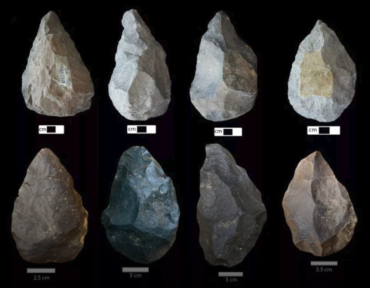
This knowledge has been firmly established through fossil and archaeological discoveries from different parts of the continent, most notably from eastern Africa.
But of course, hominins didn't stay only in Africa. A little more than two million years ago, pre-Homo sapiens populations started to disperse out of the continent. They went first to nearby territories like Southwest Asia and Arabia, then ventured further and reached eastern China by about two million years ago and Europe around one million years ago. From there, they kept moving. Today, there's almost no place on earth that doesn't hold traces of humanity.
This movement played a vital role in introducing ancient humans to new ideas, survival opportunities and risks. Those experiences helped our lineage to emerge as a resilient and adept species, which is evident in the technological ingenuity of modern humans.
So, given that dispersal has been such a vital process in our evolutionary history, where do we trace the first glimpse of it? The Nile corridor and the Strait of Bab-al-Mandeb on the southern end of the Red Sea have often been suggested as possible routes for hominin dispersals out of Africa. But the available evidence linking these regions to hominin dispersal is limited, and there is no strong consensus among researchers if these routes were always accessible or most desired by hominins.
For example, while the presence of the Nile River makes dispersal along the Nile basin most plausible, the main Nile channel is believed to have ceased to exist between 1.8 and 0.8 million years ago. But there is evidence of hominin dispersal from Africa into the Levant (the area encompassing modern day Palestine, Israel, Lebanon, Syria, Jordan and Iraq) dating to that time span. Without the Nile, could hominins have used a different route to reach the Levant?
Today at the Bab-el-Mandeb straits, the Red Sea is about 12 miles (20 kilometres) wide, but 50,000 years ago it was much narrower and sea levels were 70 metres lower. Though the straits were never completely closed, there may have been islands in between which could be reached using simple rafts. Wikipedia
Recently we led a research team to fill the existing evidence gap about our ancestors' route out of Africa. Our focus was on the western periphery of the Red Sea. This area links the fossil-rich Horn of Africa and the Sinai Peninsula, which is the only land bridge that could have facilitated direct hominin movement between Africa and Eurasia in the past two million years.
We found evidence of hominin settlement in the area in the form of stone artefacts that suggests this region was a key early dispersal corridor - and possibly the first. That evidence includes stone tools, colloquially referred to as handaxes or bifaces. These were associated initially with the first fully bipedal (upright walker) hominin species, Homo erectus, and subsequently with other species.
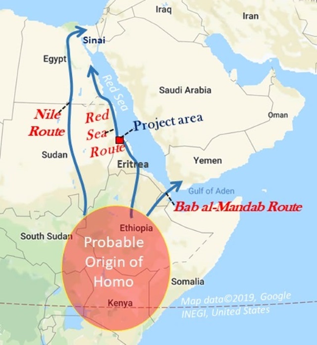
Studying the sites
Our study area is situated in the Sudanese Red Sea region. It encompasses the coastal plains that surround the Gulf of Agig and the Khor Baraka basin; 'khor' means ravine in Arabic.
The Agig plains and Khor Baraka feature low plains and a network of coast-bound drainage systems that stretch away from the Red Sea Hills. This amounts to a typical human-supporting landscape.
We spent three weeks in the field, the first of several seasons we plan to spend focusing on this area. Our team documented five Stone Age sites and numerous stone tools scattered across diverse landscapes. The most conspicuous and widespread finds were what archaeologists colloquially refer to as handaxes or bifaces.
The stone tool techno-complex associated with handaxe-making is conventionally called 'Acheulean', after a site in France called Saint-Acheul where such toolkits were first discovered in the mid-19th century. The handaxes we found reveal signs of controlled shaping and greater selectivity of raw material. The tool-makers were targeting fine-grained volcanic rocks as raw material, which demonstrates that they had the ability to identify good quality rocks that are easy to break and produce effective cutting edges. Based on their shape, we think the tools may have been used for cutting meat, extracting bone marrow or processing plant foods.
No fossils have been found yet to confirm who made the tools. But the level of technical skills needed to create them hints at a well-developed understanding of the mechanical properties of the worked rocks and increased dependency on stone tools. Maintaining such a viable technological system must have required stable - and cooperating - social groups and advanced cognition.
Because of its versatility, Acheulean technology is thought to have promoted a mobile lifestyle. Armed with their bifaces, the hominins who lived in our study area could easily have dispersed to and survived in diverse habitats. The most likely path was northward from the Gulf of Agig and the Khor Baraka basin up to the Sinai Peninsula and beyond.
More work to come
These finds, and others at the site, have not yet been dated. But based on the technological features of the artifacts so far recorded in the study area, these sites seem to be comparable to East African sites dated to between 1.25 million and 500,000 years ago.
There's much more work to be done at these sites. We plan to keep investigating there to pinpoint the environmental and chronological contexts of early hominin adaptations in this ecologically and geographically unique part of Africa.
Written by:
- Amanuel Beyin, Assistant Professor, Department of Anthropology, University of Louisville
- Ahmed Hamid Nassr, Assistant Professor, College of Arts, Department of Tourism & Archaeology, University of Ha'il
- Parth Randhir Chauhan, Assistant Professor, Deptartment of Humanities and Social Sciences, Indian Institute of Science Education and Research Mohali
"Oldest human skull outside Africa identified as 210,000 years old"
Apidima 2 and its reconstruction: Katerina Harvati, Eberhard Karls University of Tübingen, HeritageDaily 12th July 2019
A 210,000-year-old human skull could provide new evidence that our species left Africa much earlier than previously thought.
A new study published in Nature of two fossils found in Greece in the 1970s shows that one of them is the oldest Homo sapiens specimen ever found outside Africa by more than 50,000 years. This exciting discovery adds to a list of recent finds that shows the story of humanity's spread across the world and interaction with other related species is much more complicated than we once thought.
The human skull was one of two cranial fossils found in Apidima Cave, one of a series of cave sites along the southwestern coast of the Peloponnese in Greece. The first, known as Apidima 1, comprised half of the rear of a skull case. Apidima 2 was a largely complete skull with a clear face, but had been heavily distorted during the fossilisation process.
Both were initially identified as Neanderthals and, as uncontroversial specimens, disappeared into the general table of fossils from humans and their closest extinct relatives (hominins). But the recent study from a multinational team led by Katerina Harvati reconstructed the specimens digitally and dated them by measuring their radioactive decay. "Geometric-morphometric" analysis allowed the researchers to reverse model the distortions of Apidima 2 to estimate what it would have originally looked like. This confirmed it was an early Neanderthal dating from around 150,000 years ago. They also digitally recreated what the whole of the Apidima 1 skull would have looked like and realised it was more likely a modern human (Homo sapiens), dating it to 210,000 years ago.
Tracing humanity's spread
Human evolution is often thought of as a linear story of new species developing and replacing older, simpler ones. This narrative originally said that modern humans in the southern cape of Africa developed a suite of original ways of thinking and communicating approximately 80,000 years ago. They dispersed out of Africa and across the world, sweeping all before them from about 70,000 years ago, leading to the demise of Neanderthals in Europe around 40,000 years ago. But this narrative has grown ever more difficult to sustain because of a range of new fossil discoveries, improvements in their dating and genetic evidence. We now know that modern humans have existed for at least 300,000 years, thanks to a fossil from the site of Jebel Irhoud in Morocco. But they didn't form a single population with a coherent pattern of behaviour before they left the continent.
Specimens from sites in the Levant (modern day Israel, Syria, Lebanon and Jordan) suggest the first wave of modern humans out of Africa were replaced by Neanderthals, before the final, more successful human migration later on.
In southern Africa, modern humans were alive at the same time as a much smaller and seemingly more primitive species called Homo naledi. Genetic evidence from Siberia and recently Tibet has identified a new hominin species - the Denisovans - that shared a history of interbreeding and interaction with Neanderthals. And the presence of Neanderthal DNA in our own genomes shows they also bred with our species.
Growing complexity
The new data from Apidima further extends this complex picture of modern human dispersal and interaction with other hominin species. For example, the earlier human skull came from a time when the surrounding environment was warmer and wetter than the cold and arid conditions the later Neanderthal specimen would have lived in.
This emphasises that our explanations for population dispersals need to take into account the context of major environmental change and the opportunities and challenges that went with it. Our traditional narratives and implicit assumptions of the evolutionary history of modern humans are well and truly broken. The ever-increasing complexity of the evidence we now have means there is no simple reason for hominin dispersal or replacement. We now need a renewed emphasis on the archaeological evidence to understand and compare what hominins were actually doing in the landscapes where we find their remains. This will enable us to explore the nature of their interactions and not just narrate their consequences.
Apidima Cave fossils provide earliest evidence of Homo sapiens in Eurasia
Katerina Harvati, Carolin Röding, Abel M. Bosman, Fotios A. Karakostis, Rainer Grün, Chris Stringer, Panagiotis Karkanas, Nicholas C. Thompson, Vassilis Koutoulidis, Lia A. Moulopoulos, Vassilis G. Gorgoulis & Mirsini Kouloukoussa, Nature 10th July 2019
Abstract
Two fossilized human crania (Apidima 1 and Apidima 2) from Apidima Cave, southern Greece, were discovered in the late 1970s but have remained enigmatic owing to their incomplete nature, taphonomic distortion and lack of archaeological context and chronology. Here we virtually reconstruct both crania, provide detailed comparative descriptions and analyses, and date them using U-series radiometric methods. Apidima 2 dates to more than 170 thousand years ago and has a Neanderthal-like morphological pattern. By contrast, Apidima 1 dates to more than 210 thousand years ago and presents a mixture of modern human and primitive features. These results suggest that two late Middle Pleistocene human groups were present at this site - an early Homo sapiens population, followed by a Neanderthal population. Our findings support multiple dispersals of early modern humans out of Africa, and highlight the complex demographic processes that characterized Pleistocene human evolution and modern human presence in southeast Europe.
"Mysterious 'ghost' populations had multiple trysts with human ancestors"
Ann Gibbons, 20th February 2020
The story of human evolution is full of ancient trysts. Genes from fossils have shown that the ancestors of many living people mated with Neanderthals and with Denisovans, a mysterious group of extinct humans who lived in Asia. Now, a flurry of papers suggests the ancestors of all three groups mixed at least twice with even older 'ghost' lineages of unknown extinct hominins. One candidate partner: Homo erectus, an early human who left Africa by 1.8 million years ago, spread around the world, and could have mated with later waves of human ancestors.
The new genomic studies rely on complex models of inheritance and population mixing, and they have many uncertainties, not least the precise identities of our ancestors' strange bedfellows and when and where the encounters took place. But, taken together, they build a strong case that even before modern humans left Africa, it was not uncommon for different human ancestors to meet and mate. "It's now clear that interbreeding between different groups of humans goes all the way back," says computational biologist Murray Cox of Massey University of New Zealand, Turitea, who was not involved in the new studies.
The gold standard for detecting interbreeding with archaic humans is to sequence ancient DNA from fossils of the archaic group, then look for traces of it in modern genomes. Researchers have done just that with Neanderthal and Denisovan genomes up to 200,000 years old from Eurasia. But no one has been able to extract full genomes from more ancient human ancestors. So population geneticists have developed statistical tools to find unusually ancient DNA in genomes of living people. After almost a decade of tantalizing but unproven sightings, several teams now seem to be converging on at least two distinct episodes of very ancient interbreeding.
In Science Advances today, Alan Rogers, a population geneticist at the University of Utah, Salt Lake City, and his team identified variations at matching sites in the genomes of different human populations, including Europeans, Asians, Neanderthals, and Denisovans. The team tested eight scenarios of how genes are distributed before and after mixing with another group, to see which scenario best simulated the observed patterns. They conclude that the ancestors of Neanderthals and Denisovans - whom they call Neandersovans - interbred with a 'super-archaic' population that separated from other humans about 2 million years ago. Likely candidates include early members of our genus, such as Homo erectus or one of its contemporaries. The mixing likely happened outside of Africa, because that's where both Neanderthals and Denisovans emerged, and it could have taken place at least 600,000 years ago.
"I think the super-archaics were in the first wave of hominids who left Africa," Rogers says. "They stayed in Eurasia, largely isolated from Africans, until 700,000 years ago when Neandersovans left Africa and interbred with them."
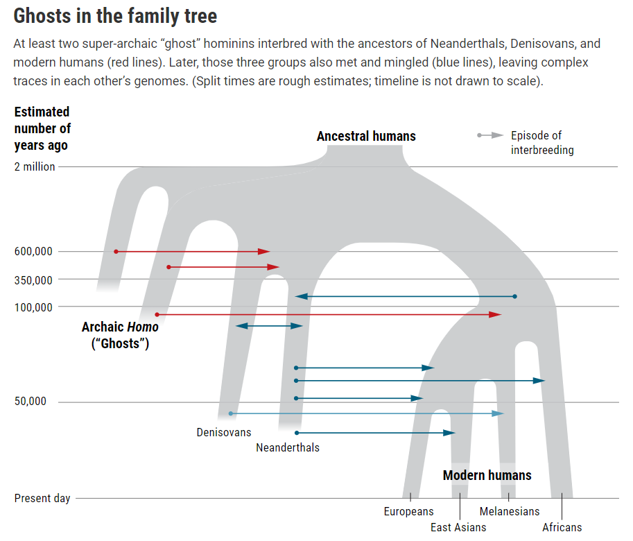
Occurring much earlier than encounters of modern humans with Neanderthals and Denisovans, the episode was "the earliest known interbreeding between ancient human populations and an expansion out of Africa," Rogers says. Other studies have hinted at such ancient mixing, Cox says, but Rogers' analysis is "particularly convincing".
Others, though, say Rogers' bold claim needs testing. One challenge is reconciling it with new results from other researchers that show modern human ancestors mixed with super-archaic groups more recently, in Africa. Just last week, for example, population geneticist Sriram Sankararaman and his student Arun Durvasula at the University of California (UC), Los Angeles, identified signs of a separate, more recent episode of mixing. The researchers analyzed the genomes of 405 people from four subpopulations in West Africa that were included in the 1000 Genomes Project, a catalog of genomes from around the world. They found numerous gene variants not seen in Neanderthals or Denisovans and concluded that the best explanation was that the variants came from an archaic, extinct human.
This ghost species may have been late Homo erectus, Homo heidelbergensis, or a close relative. One or more late-surviving members of this ancient group met and mated with the ancestors of living Africans sometime in the past 124,000 years, the modern genomes suggest.
Another paper last month reported Neanderthal DNA in living Africans, likely from migrations back to Africa by early Europeans who bore Neanderthal DNA. Sankararaman thinks some of the archaic DNA he detects in Africans may be from Neanderthals, but most is from the older ghost species. "I think the true picture is a combination of both an archaic population unrelated to Neanderthals as well as Neanderthal-related ancestry," he says.
In December 2019, yet another study found hints of an extinct ghost population in living Africans, although it was silent on the identity of the ghosts and when they bred with our ancestors. Population geneticist Jeff Wall at UC San Francisco and colleagues analyzed 1,667 genomes from diverse populations in the GenomeAsia 100K consortium. They reported the strongest ghost signal in the Khoisan people and in Central African hunter-gatherers formerly known as pygmies.
But Wall and others warn their methods cannot rule out that the 'ghosts' could be one or several groups of modern humans in Africa that were separated from other moderns for so long that their genes looked 'archaic' when the groups finally came together again and mixed. "Our understanding of African population history, in particular, is so far behind", says Joshua Akey of Princeton University.
Even if they differ on particulars, the studies emphasize that long after new lineages of humans emerge, they still can mix with others quite different from themselves. Other species, such as cave bears and mammoths, show the same pattern of divergence and later mixing, says population geneticist Pontus Skoglund of the Francis Crick Institute in London. "We are losing the idea that separation between populations is simple with instant isolation". Such mating between long isolated groups may quickly introduce valuable new genes (Science, 18 November 2016, page 818). For example, some of the archaic alleles Sankararaman spotted in Africans were in genes that suppress tumours and regulate hormones.
Today, Homo sapiens doesn't have the possibility of quickly grabbing a load of diversity by mating with another group: For perhaps the first time in our history, we're the only humans on the planet. It's another reason to miss our extinct cousins, says population geneticist Carina Schlebusch of Uppsala University. "To have such a large densely spread species with … so little genetic diversity … is a dangerous situation", she says.
Callum Hoare, Daily Express, 30th April 2019
How archaeologist discovered 'true location' after Jerusalem find. The Garden of Eden's location may have finally been found thanks to a discovery by an archaeologist in the Church of the Holy Sepulchre in Jerusalem, a documentary claimed.
The Garden of Eden, also referred to as Paradise, is the biblical garden of God described in the Book of Genesis about the creation of man. The narrative surrounds the apparent first man and woman - Adam and Eve - placed in the garden to guard the Tree of Life, before being tempted by a serpent to eat from a forbidden tree, a move that saw them expelled. Many have long searched for its location, based on clues given in the biblical text, but the age-long question may have finally been uncovered.
Archaeologist Jodi Magness revealed during Morgan Freeman's documentary 'The Story of God', how a discovery in a church in Jerusalem led her to believe she has the answer.
The Church of the Holy Sepulchre is located in the Old City and is believed to be the site where Jesus of Nazareth was crucified and later resurrected - in a place known as 'Calvary', or 'Golgotha'.
Dr Magness revealed how this was also the apparent burial place for Adam. She said in 2017:
"[The clue comes from] underneath the rock of Golgotha, the rocky outcrop on which Christians believe Jesus was crucified. Below is the chapel of Adam and there is a tradition which goes way back in Christianity which connects this spot to Adam - the first man. When Jesus was crucified on top of the rock above us, his blood flowed down through a crack in the rock. And Adam, the first man, lay buried underneath, but when Jesus' blood flowed onto him, he was resurrected."
This idea contradicts the description given in the Bible. The Book of Genesis clearly lists four rivers in association with the garden, Pishon, Gihon, Chidekel and Phirat, suggesting its location was in southern Mesopotamia, now known as Iraq. However, Dr Magness detailed how this may actually support a theory she has. She added:
"Well, the version of the story that ended up in the Book of Genesis seems to place the Garden of Eden somewhere in Mesopotamia. But I think Adam had a very special connection with Jerusalem. The Garden of Eden, or Paradise, becomes conceptualised as the spot where the presence of God dwells. In early Judaism and the time of Jesus the presence of God dwelled in the temple, and hence why Jerusalem was conceived of as Eden [at that time]."
Dr Magness was asked if she believed the Garden of Eden is actually a metaphor for the beginning of life and is, in fact, wherever God's presence is. She responded:
"Well, yes - of course. Adam was the first human and, in Hebrew, the word 'Adam' means 'man'. Also, if you take off the 'a', you are left with 'dam', in Hebrew that means 'blood'. And if you add 'ah' to the end, 'adamah' means land."