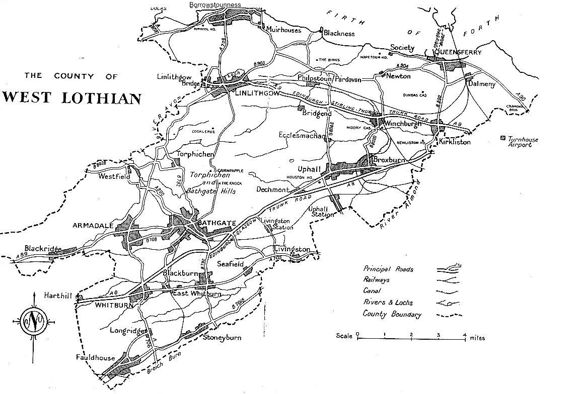
West Lothian (Linlithgowshire)
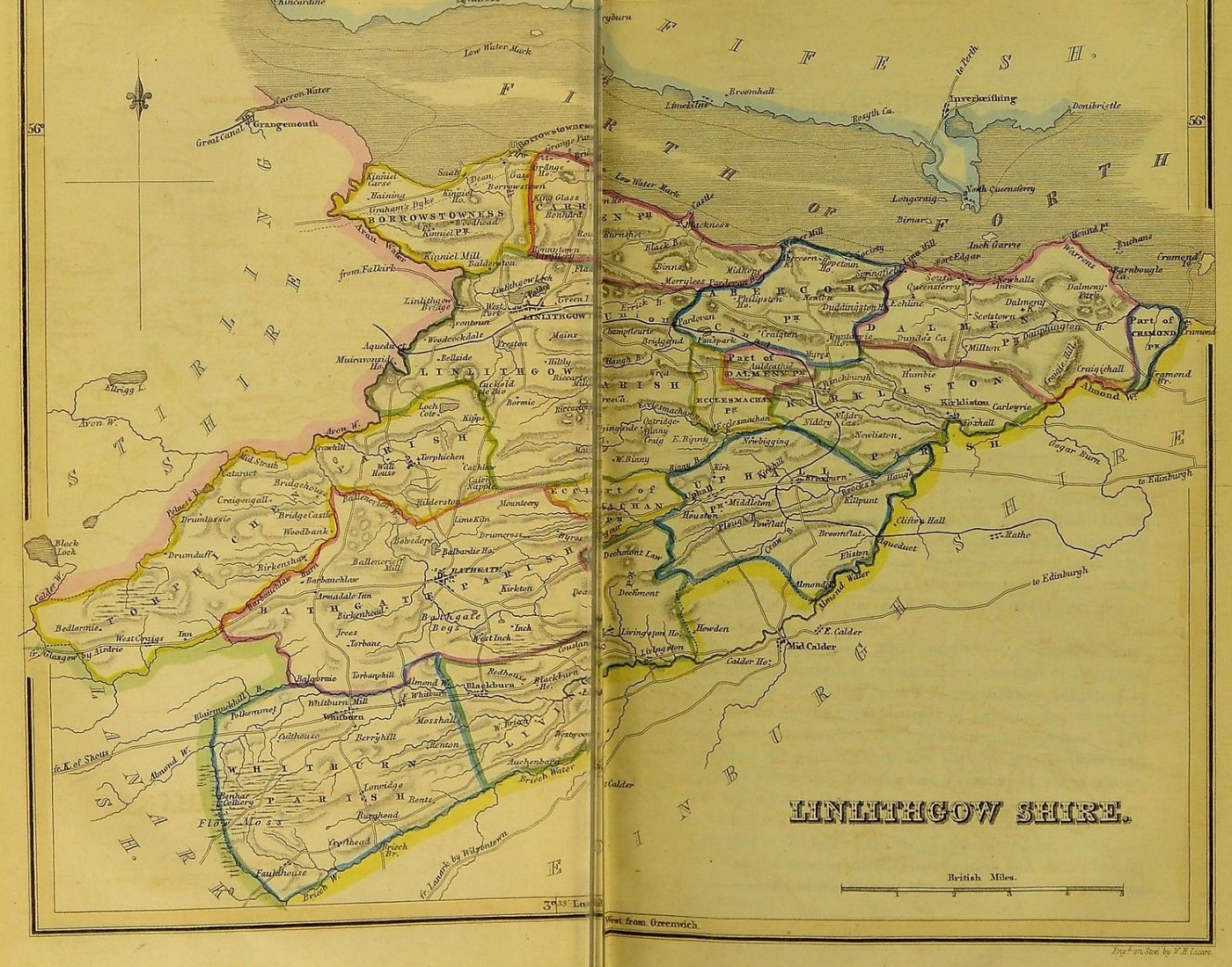
Parish map of Linlithgowshire
"The New Statistical Account of Scotland" (1845)
LINLITHGOWSHIRE, (or West Lothian), maritime county in south-east of Scotland; is bounded north by Firth of Forth, southeast by Edinburghshire, and west by Lanarkshire and Stirlingshire; greatest length, northeast and southwest, 19 miles; greatest breadth, east and west, 14 miles; area, 76,806 acres, population 43,510. The coast is low; the surface is varied, but there are few hills of any height; the chief rivers are the Avon on the west and the Almond on the east border. Much of the soil is fertile, and agriculture is in an advanced condition. Linlithgowshire is one of the richest mineral counties in Scotland, coal, shales, ironstone, freestone, limestone, &c; being very abundant. Paraffin oil is largely manufactured at Bathgate, Broxburn, and Uphall. The county contains 12 parochs and 2 parts, the parliament and royal burghs of Linlithgow (Falkirk Burghs) and Queensferry (Stirling Burghs), and the police burghs of Armadale, Bathgate, Borrowstounness, and Whitburn. It returns 1 member. [Bartholemew's Gazetteer of the British Isles, 1887]
Parishes in West Lothian
The following is a list of the 13 parochs of West Lothian, together with the date of the earliest surviving baptism or marriage record for each paroch:
Abercorn 1585 Bathgate 1672 Borrowstouness 1648 Carriden 1687 Dalmeny 1628 Ecclesmachen 1717 Kirkliston 1675 Linlithgow 1613 Livingston 1639 Queensferry 1635 Torphichen 1693 Uphall 1598 Whitburn 1719 ABERCORN
A village and a coast parish of Linlithgowshire. Lying ¼ miles inland, near the confluence of the Cornie and Midhope Burns, the village - a pretty little place, nestling among trees and gardens on the verge of a high bank - is 3¾ miles west of its post-town South Queensferry, and 3 north-northwest of Winchburgh station.
The parish contains also the hamlets of Philipstoun, 2½ miles southwest of Abercorn village, and Society, on the coast, 1¼ miles east by north. It is bounded north for 3¾ miles by the Firth of Forth (here 2½ miles wide), east by Dalmeny, southeast by Kirkliston, south by the Auldcathie portion of Dalmeny and by Ecclesmachen, southwest by Linlithgow, and west by Carriden, from which it is parted by the Black Burn. (Extract from Groomes Ordnance Gazetteer of Scotland circa 1895)
Abercorn's Population
[1801 - 1891]1801 814 1821 1044 1871 933 1891 863 BATHGATE
A town and a parish in the southwest of Linlithgowshire. The town stands in the middle of the parish, 6 miles south by west of Linlithgow, whilst by sections of the North British, that converge to it from east, south, west, and northwest, it is 19¾ west by south of Edinburgh, 14¼ northeast of Morningside, 16 east by north of Coatbridge, 24¾ east by north of Glasgow, and 8½ south of Manuel Junction. Its situation is a pleasant one. The hilly grounds to the northeast, and the beautiful park of Balbardie on the north, give a cheerful aspect to the town, which consists of two parts, the old and the new. The old stands on a ridgy declivity, and has narrow crooked lanes; the new town, on low ground, is regularly aligned, and has well-built streets. A considerable extension occurred after the opening of the Bathgate and Edinburgh railway in 1849; a greater one, after the establishment of a neighbouring paraffin work in 1852; and other ones, or rather a continually increasing one, after the subsequent commencing or enlargement of other neighbouring works connected with mines and with mineral produce. The inhabitants prior to the first of these extensions, had little other employment than hand-loom weaving, and lived in a state of penury; but the new works employed not only them but numerous immigrants from other towns. (Extract from Groomes Ordnance Gazetteer of Scotland circa 1895)
Bathgate's Population
[1801 - 1891]1801 2513 1831 3593 1861 10,134 1891 11,359 BORROWSTOUNESS
Borrowstounness or Bo'ness, a town and a parish of northwest Linlithgowshire. A seaport, a burgh of barony since 1748, and a police burgh since 1880, the town stands at the northeast angle of the parish on a low ness or promontory washed by the Firth of Forth; by road it is 3 miles north of Linlithgow and 8 east-northeast of Falkirk, by water 2¾ miles south-southeast of Culross, and by rail, as terminus of a section of the North British, 4¼ miles north-northeast of Manuel Junction, 24 west-northwest of Edinburgh, and 29¼ east-northeast of Glasgow. Defoe described it, early in last century, as consisting only of one straggling street, extended close to the water along the shore, but 'a town that has been, and still is, of the greatest trade to Holland and France of any in Scotland, after Leith'.(Extract from Groomes Ordnance Gazetteer of Scotland circa 1895)
Bo'ness' Population
[1851 - 1891]1851 2645 1861 4561 1871 4256 1881 5284 1891 5866 CARRIDEN
Carriden, a coast parish of Linlithgowshire, containing the villages of Blackness, Bridgeness, Grangepans, and Muirhouses. It approaches within 3 furlongs and 1 mile of the post-towns and railway stations of Borrowstouness and Linlithgow; and is bounded N by the Firth of Forth, E by Abercorn, S by Linlithgow, and W by Bo'ness. Its greatest length, from E to W, is 3¼ miles; its greatest breadth, from N to S is 1¾ miles; and its area is 2708¼ acres, of which 3¼ are water. The surface, rising somewhat rapidly from the shore to a line about 1 mile inland, declines thence, for the most part, to the southern boundary, but rises again south-westward towards Glower-o'er-em (559 feet) in Borrowstouness; in Carriden itself rarely much exceeds 300 feet above sea-level. Two small headlands are respectively at Blacknes in the E and at Bridgeness in the W. The rocks are partly eruptive, partly carboniferous. Trap rock and sandstone are occassionally worked; coal, has, from time immemorial, been extensively mined; and a deposit of clay, about 12 feet deep, at Brickfield near Blackness, has been extensively used for making bricks and tiles. Two streamlets, Carriden and Blackness Burns, drain most of the interior to the Forth. The soil is generally light and early, capable of producing good crops. (Extract from Groomes Ordnance Gazetteer of Scotland c.1895)
Carriden's Population
[1881 - 1891]1881 1985 1891 2453 DALMENY
A village and a coast parish of NE Linlithgowshire. The village stands 3 furlongs N by E of Dalmeny station. The ¾ mile of railway from the village to the Bridge belongs to the Forth Bridge Railway Co., and from Dalmeny a branch turns off to Winchburgh connecting with Glasgow and the west, and another to Corstorphine connecting with Edinburgh and the east. Dalmeny has a post office under Edinburgh, and is a pretty little place; it commands from its rising-ground a fine view over the neighbouring Firth. The parish, containing also the hamlet of Craigie, since 1636 has excluded the royal burgh of South Queensferry, which it surrounds on all the landward sides. It is bounded N by the Firth of Forth (here from 9 furlongs to 3¾ miles broad), E by Cramond, S by Corstorphine in Midlothian and by Kirkliston, and W by Abercorn. (Extract from Groomes Ordnance Gazetteer of Scotland c.1895)
Dalmeny's Population
[1801 - 1891]1801 765 1831 1291 1861 1274 1871 1492 1881 1660 1891 2091 ECCLESMACHAN
Ecclesmachan (Celtic 'church of St Machan'), a village and a parish of Linlithgowshire. The village stands 2¼ miles N by W of Uphall station, 3 WSW of Winchburgh station, and 4¾ ESE of Linlithgow. The parish until 1891 consisted of two portions, separated by a strip of Linlithgow parish, 1 mile broad at the narrowest. In that year, however, the Boundary Commissioners united the two portions of Ecclesmachan by transferring to that parish the intervening Linlithgow strip. It at the same time received a further accession of territory by having transferred to it also the western portion of Dalmeny parish, the eastern portion going to Kirkliston. While the south-western portion was the larger of the two, the north-eastern contained the village. (Extract from Groomes Ordnance Gazetteer of Scotland circa 1895)
Ecclesmachan's Population
[1801 - 1891]1801 303 1831 299 1861 309 1871 329 1881 278 1891 506 KIRKLISTON
A village in Linlithgowshire, and a parish also in Edinburghshire. The village, occupying a rising-ground on the left bank of Almond Water, has a station on the Queensferry branch of the North British, 1½ miles NNW of Ratho Junction, 3½ miles S of South Queensferry, and 10 W (by road only 8) of Edinburgh. It takes name from the parish church and Liston Manor, being distinguished by the prefix Kirk from Old Liston, New Liston, Over New Liston, Hal Liston, and Illiston or High Liston, all in the same parish. Some of its houses are good and modern, yet it offers on the whole a poor appearance; and has a post office, with money order, savings bank, and telegraph departments, an inn, and a long-established distillery. (Extract from Groomes Ordnance Gazetteer of Scotland circa 1895)
Kirkliston's Population
[1881 - 1891]1881 2580 1891 3777 LINLITHGOW
A parish containg the royal burgh of the same name in the NW of the county of Linglithgow. A south-eastern projection of the parish, a mile broad at the narrowest, that separated the parish of Ecclesmachan from its detached part, was in 1891 transferred by the Boundary Commissioners to that parish. It is bounded N by Carriden parish, NE by Abercorn, E and SE by Ecclesmachan, S by Ecclesmachan and Bathgate, SW by Torphichen, W by Stirlingshire and NW by Borrowstounness parish. The boundary with Stirlingshire is the river Avon, over a distance of 4¾ miles, and in the NE and SE the line follows for some distance the Haugh and Mains Burns; elsewhere it is mostly artificial. The greatest length of the parish, from the river Avon west of Carribber on the W to the boundary with Ecclesmachan on the E, is 6 miles; and the greatest breadth, from the road N of Bonside on the N to Silvermine on the S, is 4¾ miles. The surface is undulating, and the height above sea-level rises from 150 feet at Linlithgow Loch, northwards to Bonnytoun Hill or Glower-o'er-'em (559) and southwards to the Riccardton Hills (832). From Bonnytoun Hill, which is just on the northern border, there is a very extensive and charming view. The north-eastern and eastern districts are mainly level, while the central hollow rises southward with a long slope to the Riccarton Hills. (Extract from Groomes Ordnance Gazetteer of Scotland circa 1895)
Linlithgow's Population
[1801 - 1891]1801 3596 1831 4874 1861 5784 1871 5554 1881 5619 1891 7520 LIVINGSTON
('Leving's town', after a Fleming of that name who settled here about the time of Alexander I.)
A parish with a village of the same name near the middle of the SE border of the county of Linlithgow. It is bounded NE by Uphall parish, E and SE by the county of Edinburgh, SW by Whitburn parish, and NW by the parishes of Bathgate and Ecclesmachan. On the SE the boundary follows the course of the river Almond from a point almost 1 mile due E of Livingston church, up to the junction with Breich Water, and then follows the course of the latter stream for 3½ miles, till near Auchinhard the parish of Whitburn is reached. From this it passes 5 furlongs NNW to the SE branch of Foulshiels Burn, down which it passes to the Almond and up the Almond to a point 2½ furlongs due W of Riddoch-hill, except at the N corner where it touches Brox Burn, the boundary is purely artificial and very irregular, the general shape of the parish showing two compact portions to the NE and SW, united by a narrow neck in the centre. (Extract from Groomes Ordnance Gazetteer of Scotland c.1895)
Livingston's Population
[1881 - 1891]1881 1484 1891 1616 SOUTH QUEENSFERRY
A small town and yet smaller parish of Linlithgowshire. The town is a royal and parliamentary burgh, the royal comprising all the parish of Queensferry, and the parliamentary extending into Dalmeny. It stands on the southern shore of the Firth of Forth, here only 1¼ miles broad, and has a station on a branch line of the North British, 5½ miles N by W of Ratho Junction and 10 WNW of Edinburgh, from which by road it is 9 miles distant. Its site is a belt of low ground at a point opposite the peninsula of North Queensferry, and the intermediate island of Inchgarvie, where the firth is suddenly and briefly, but very greatly, contracted in breadth. The ground behind the town rises abruptly; and immediately at the summit, or even on the slope of the steep bank, becomes open agricultural country. The town comes first into notice as the station at which St Margaret, the queen of Malcolm Ceannmor, crossed the Forth in her numerous excursions between Edinburgh and Dunfermline during 1068 and 1093; and it received in honour of her both its present name and some early Latin designations of similar import. e.g., Portus Reginae (1164) and Passagium Reginae(1182). (Extract from Groomes Ordnance Gazetteer of Scotland circa 1895)
South Queensferry's Population
[1841 - 1891]1841 1233 1851 1195 1861 1230 1871 1521 1881 1966 1891 1531 TORPHICHEN
(Gaelic torr-fithichean, 'the raven's hill').
A village and a parish of W Linlithgowshire. The village stands 1½ miles ENE of Westfield station, 4½ miles SSW of Linlithgow, and 2½ N by W of Bathgate, under which it has a post office. A place of great antiquity, and once of much importance, it now has an entirely rural character, and presents a straggling but pleasant appearance. (Extract from Groomes Ordnance Gazetteer of Scotland circa 1895)
Torphichen'sPopulation
[1881 - 1891]1881 1526 1891 1724 UPHALL
A village and a parish of S Linlithgowshire. The village stands, on the left bank of the Brox Burn, 1½ miles W by S of the town of Broxburn, and 7 furlongs N by W of Uphall station on the North British railway, this being 13¾ miles WSW of Edinburgh, and 5¾ E by N of Bathgate. It has a post office, with money order, savings bank, and telegraph departments, a public hall, a parish church hall, two inns, one of them a well-known coaching stage. The parish, containing also the town of Broxburn, originally was known as Strathbroke ('valley of the brock or badger'); and it took that name from the Burn of Brocks or Brocks' Burn, corrupted now into Brox Burn. It is bounded NE and E by Kirkliston, SE and S by Kirknewton and Midcalder in Edinburghshire, and W and NW by Livingston and Ecclesmachen. Its utmost length, from ENE to WSW, is 4¼ miles; its utmost width 3½ miles; and its area is 4561¼ acres, of which 20¼ are water. (Extract from Groomes Ordnance Gazetteer of Scotland circa 1895)
Uphall's Population
[1801 - 1891]1801 786 1831 1254 1861 1507 1871 2772 1881 4812 1891 8653 WHITBURN
A village and a parish of SW Linlithgowshire. The village stands, 620 feet above sea-level, near the northern verge of the parish, 3¾ miles SSW of Bathgate, 9 furlongs W by S of Whitburn station on the Morningside section of the North British, and 3¼ miles N by W of Breich station on the Caledonian, this being 21½ miles WSW of Edinburgh and 27¾ E by S of Glasgow. A police burgh since 1862, it presents a well-built regular appearance, and has a post office, with money order, savings bank, and telegraph departments, a branch of the Commercial Bank, a gaswork, a reading-room, a public coffee house and reading-room (the gift of Lady Baillie), a public hall, a cemetery, and bowling and curling clubs. (Extract from Groomes Ordnance Gazetteer of Scotland circa 1895)
Whitburn's Population
[1801 - 1891]1801 1537 1831 2075 1861 5511 1871 6911 1881 6326 1891 5782 Cemeteries in West Lothian
"Monumental inscriptions (pre-1855) in West Lothian"by John F Mitchell & Sheila Mitchell; Published Edinburgh, 1969 (Scottish Genealogy Society)
Libraries and Archives
Many local records may be consulted at the West Lothian Local History Library, Tam Dalyell House (formerly County Buildings), Linlithgow Partnership Centre, High Street, Linlithgow, West Lothian EH49 7EQ. Opening hours:
- Monday: 9am - 5pm
- Tuesday: 9am - 7pm
- Wednesday: 9am - 5pm
- Thursday: 9am - 7pm
- Friday: 9am - 5pm
- Saturday: 9am - 1pm
The following is a list of libraries and archives located in the Lothians (Edinburghshire, Linlithgowshire & Haddingtonshire)
City of Edinburgh District Council Archives
Level 1
City Chambers
253 High Street
Edinburgh EH1 1YJ
Tel: +44 (0)131 529 4616
email: archives@edinburgh.gov.ukThe Court of the Lord Lyon
HM New Register House
Edinburgh EH1 3YT
email: lyonoffice@scotland.gsi.gov.ukEdinburgh Room
Edinburgh City Libraries
George IV Bridge
Edinburgh EH1 1EG
Tel: +44 (0)131 242 8053
email: central.library.roomhire@edinburgh.gov.ukEdinburgh University Library
Department of Manuscripts
30 George Square
Edinburgh EH8 9LJ
Tel: +44 (0)131 650 8379
email: is-crc@ed.ac.ukHeriot-Watt University Archives
Ground floor Cameron Smail Library
Riccarton
Currie
Edinburgh EH14 4AS
Tel: +44 (0)131 451 3218
email: heritage@hw.ac.ukMidlothian Council Library
Local Studies Officer
2 Clerk Street
Loanhead EH20 9DR
Tel: +44 (0)131 271 3976
email: local.studies@midlothian.gov.ukNational Library of Scotland
George IV Bridge
Edinburgh EH1 1EW
Tel: +44 (0)131 623 3876
email: manuscripts@nls.ukNational Library of Scotland Map Room
137 Causewayside
Edinburgh EH9 1PH
Tel: +44 (0)131 623 4660
email: maps@nls.ukScottish Archive Network
Scottish Archive Network Limited
National Records of Scotland
HM General Register House
2 Princes Street
Edinburgh EH1 3YY
email: onlineresources@nrscotland.gov.ukScottish Documents
The National Records of Scotland
HM General Register House
2 Princes Street
Edinburgh EH1 3YY
Tel: +44 (0)131 535 1314
email: onlineresources@nrscotland.gov.ukScottish Genealogy Society
15 Victoria Terrace
Edinburgh EH1 2JL
Tel: +44 (0)131 220 3677
email: enquiries@scotsgenealogy.comScottish Record Office
General Register House
Princes Street
Edinburgh EH1 3YY
Tel: +(0) 131 535 1314
3 West Register Street
Edinburgh EH1 3YT
Tel: +44 (0)131 314 4411West Lothian Civic Centre
Howden South Road
Livingston EH54 6FF
Tel: +44 (0)1506 280000
email: customer.service@westlothian.gov.uk
Library HQ
Connolly House
Hopefield Road
Blackburn
West Lothian EH47 7HZ
Tel: +44 (0)1506 776331Copyright © David Ramsdale 1997 - 2021
All rights reserved